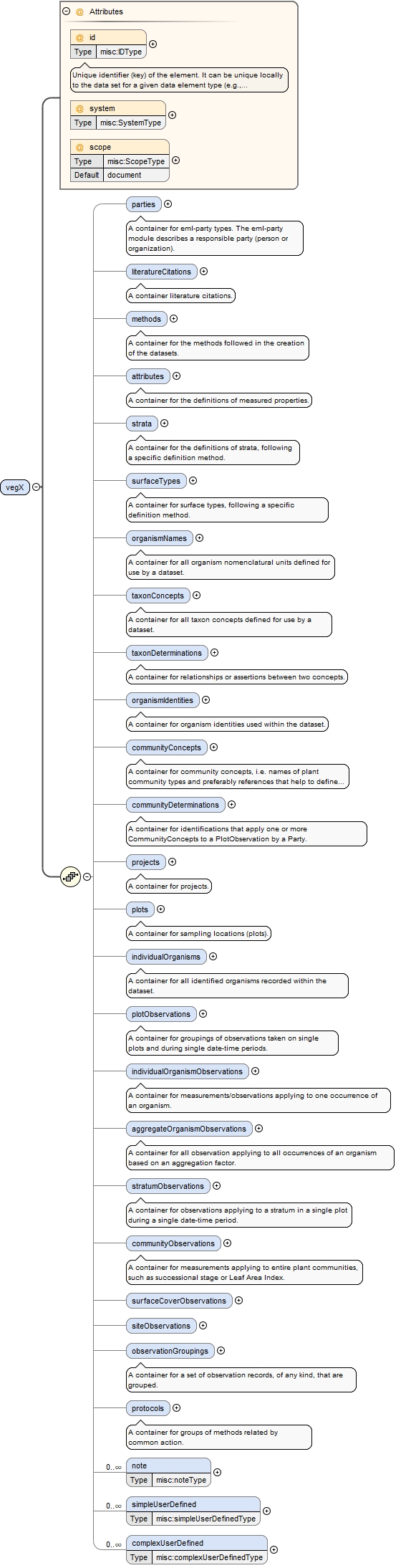
Unique identifier (key) of the element. It can be unique locally to the data set for a given data element type (e.g., plots) or a GUID in which case it can be resolved to a location on the internet where the record is stored. This identifier is used elsewhere in a dataset instance to reference this specific element when it is referred to in a repeatable way by other part of the schema. For example, a single plot entity may be the basis for numerous measurements of different types (e.g., plot observation and aggregated organism observation). Therefore the plot entity is stored in a single location within schema and referenced by this identifier rather than repeating this information throughout the dataset instance. The identifier may have a specific system and scope.
<xsd:element name="vegX"><xsd:complexType><xsd:sequence><xsd:element name="parties" minOccurs="0"><xsd:annotation><xsd:documentation>A container for eml-party types. The eml-party module describes a responsible party (person or organization).</xsd:documentation></xsd:annotation><xsd:complexType><xsd:sequence><xsd:element name="party" type="misc:partyType" maxOccurs="unbounded"><xsd:annotation><xsd:documentation source="EML" xml:lang="en">The eml-party module describes a responsible party (person or organization), and is typically used to name the originator of a resource or metadata document.</xsd:documentation></xsd:annotation></xsd:element></xsd:sequence></xsd:complexType></xsd:element><xsd:element name="literatureCitations" minOccurs="0"><xsd:annotation><xsd:documentation>A container literature citations.</xsd:documentation></xsd:annotation><xsd:complexType><xsd:sequence><xsd:element name="literatureCitation" type="misc:literatureCitationType" maxOccurs="unbounded"><xsd:annotation><xsd:documentation source="eml" xml:lang="en">Provides information about the literature citation. Basically a citation string that should be parsed to derive authors, year, title, etc. DOI may be also specified to facilitate the identification of the document</xsd:documentation></xsd:annotation></xsd:element></xsd:sequence></xsd:complexType></xsd:element><xsd:element name="methods" minOccurs="0"><xsd:annotation><xsd:documentation>A container for the methods followed in the creation of the datasets.</xsd:documentation></xsd:annotation><xsd:complexType><xsd:sequence><xsd:element name="method" type="misc:MethodType" maxOccurs="unbounded"><xsd:annotation><xsd:documentation xml:lang="en">A specific method definition followed in the creation of the dataset. Each method links to a protocol and literature citation reference. A protocol may have many method or steps.</xsd:documentation></xsd:annotation></xsd:element></xsd:sequence></xsd:complexType></xsd:element><xsd:element name="attributes" minOccurs="0"><xsd:annotation><xsd:documentation>A container for the definitions of measured properties.</xsd:documentation></xsd:annotation><xsd:complexType><xsd:sequence><xsd:element name="attribute" type="misc:AttributeType" maxOccurs="unbounded"><xsd:annotation><xsd:documentation xml:lang="en">A specific definition of a measured property. An attribute has to be one of three types: qualitative (unordered categorical variable, i.e. nominal), ordinal (ordered list of values) or quantitative (a numerical variable, either discrete or continuous</xsd:documentation></xsd:annotation></xsd:element></xsd:sequence></xsd:complexType></xsd:element><xsd:element name="strata" minOccurs="0"><xsd:annotation><xsd:documentation>A container for the definitions of strata, following a specific definition method.</xsd:documentation></xsd:annotation><xsd:complexType><xsd:sequence><xsd:element name="stratum" type="plot:StratumType" maxOccurs="unbounded"><xsd:annotation><xsd:documentation xml:lang="en">The specific definition of a stratum referred to by observations in the dataset. A stratum usually belongs to a ordered list that together are the set of strata definitions in use in a specific dataset. It contains the stratum name (e.g. tree layer) as well as an identification code. It may also contain an indication of a position in an ordered sequence of strata.</xsd:documentation></xsd:annotation></xsd:element></xsd:sequence></xsd:complexType></xsd:element><xsd:element name="surfaceTypes" minOccurs="0" maxOccurs="1"><xsd:annotation><xsd:documentation>A container for surface types, following a specific definition method.</xsd:documentation></xsd:annotation><xsd:complexType><xsd:sequence><xsd:element name="surfaceType" type="plot:SurfaceTypeType" minOccurs="1" maxOccurs="unbounded"><xsd:annotation><xsd:documentation>The definition of a surface type, not the observation of cover on them.</xsd:documentation></xsd:annotation></xsd:element></xsd:sequence></xsd:complexType></xsd:element><xsd:element name="organismNames" minOccurs="0"><xsd:annotation><xsd:documentation>A container for all organism nomenclatural units defined for use by a dataset.</xsd:documentation></xsd:annotation><xsd:complexType><xsd:sequence><xsd:element name="organismName" type="org:OrganismNameType" maxOccurs="unbounded"><xsd:annotation><xsd:documentation>The name of an organism used in the data set. This will normally be a nomenclatural unit of any rank (order, family, genus, species, subspecies, etc.). If it is a formal scientific name (not necessarily including authority) then the attribute 'taxonName' should be set to true. However, the organism name can be a morphospecies, a field name... cases in which the attribute 'taxonName' should be set to false.</xsd:documentation></xsd:annotation></xsd:element></xsd:sequence></xsd:complexType></xsd:element><xsd:element name="taxonConcepts" minOccurs="0"><xsd:annotation><xsd:documentation>A container for all taxon concepts defined for use by a dataset.</xsd:documentation></xsd:annotation><xsd:complexType><xsd:sequence><xsd:element name="taxonConcept" type="org:TaxonConceptType" maxOccurs="unbounded"><xsd:annotation><xsd:documentation>Representation of a taxon concept (i.e., an organism name and the organism description given by an author in a publication). A taxon concept may be referenced in an organism identity as the original concept used by the author of the data set, or it can be referenced in taxonDetermination allowing an organism identity to be mapped to a taxonomic concept by third parties after re-examination.</xsd:documentation></xsd:annotation></xsd:element></xsd:sequence></xsd:complexType></xsd:element><xsd:element name="taxonDeterminations" minOccurs="0"><xsd:annotation><xsd:documentation>A container for relationships or assertions between two concepts.</xsd:documentation></xsd:annotation><xsd:complexType><xsd:sequence><xsd:element name="taxonDetermination" type="org:TaxonDeterminationType" maxOccurs="unbounded"><xsd:annotation><xsd:documentation xml:lang="en">A specific relationship or assertion between two name concepts which are not part of the original definition of either of these concepts; possibly by a third party. Within vegX this typically allows for an organism identity, to be linked to a specific taxa treatment (taxon concept), according to a third party. Similar to a tcs TaxonRelationshipAssertion.</xsd:documentation></xsd:annotation></xsd:element></xsd:sequence></xsd:complexType></xsd:element><xsd:element name="organismIdentities" minOccurs="0"><xsd:annotation><xsd:documentation>A container for organism identities used within the dataset.</xsd:documentation></xsd:annotation><xsd:complexType><xsd:sequence><xsd:element name="organismIdentity" type="org:OrganismIdentityType" maxOccurs="unbounded"><xsd:annotation><xsd:documentation>The identity of an organism (or a set of organisms) occurring within the dataset.</xsd:documentation></xsd:annotation></xsd:element></xsd:sequence></xsd:complexType></xsd:element><xsd:element name="communityConcepts" minOccurs="0" maxOccurs="1"><xsd:annotation><xsd:documentation>A container for community concepts, i.e. names of plant community types and preferably references that help to define the types.</xsd:documentation></xsd:annotation><xsd:complexType><xsd:sequence><xsd:element name="communityConcept" type="comm:CommunityConceptType" minOccurs="1" maxOccurs="unbounded"><xsd:annotation><xsd:documentation xml:lang="EN">A name of a plant community type, preferably together with a reference that helps to define the type.</xsd:documentation></xsd:annotation></xsd:element></xsd:sequence></xsd:complexType></xsd:element><xsd:element name="communityDeterminations" minOccurs="0"><xsd:annotation><xsd:documentation>A container for identifications that apply one or more CommunityConcepts to a PlotObservation by a Party.</xsd:documentation></xsd:annotation><xsd:complexType><xsd:sequence><xsd:element name="communityDetermination" type="comm:CommunityDeterminationType" maxOccurs="unbounded"><xsd:annotation><xsd:documentation xml:lang="en">An application of one or more communityConcepts to a plotObservation.</xsd:documentation></xsd:annotation></xsd:element></xsd:sequence></xsd:complexType></xsd:element><xsd:element name="projects" minOccurs="0"><xsd:annotation><xsd:documentation>A container for projects.</xsd:documentation></xsd:annotation><xsd:complexType><xsd:sequence><xsd:element name="project" type="misc:projectType" maxOccurs="unbounded"><xsd:annotation><xsd:documentation source="EML" xml:lang="en">Describes the research context in which the dataset was created, including descriptions of over-all motivations and goals, funding, personnel, description of the study area etc. Sub-element definitions were taken from Ecological Markup Language (EML).</xsd:documentation></xsd:annotation></xsd:element></xsd:sequence></xsd:complexType></xsd:element><xsd:element name="plots" minOccurs="0"><xsd:annotation><xsd:documentation>A container for sampling locations (plots).</xsd:documentation></xsd:annotation><xsd:complexType><xsd:sequence><xsd:element name="plot" type="plot:PlotType" maxOccurs="unbounded"><xsd:annotation><xsd:documentation xml:lang="en">A plot is a sampling location, represented as one or more points, lines, polygons, or volumes, and is the basis for experimentation or measurement. Its properties, like the position, are assumed to be constant on time scales commonly used for direct observations. Plots may have no explicit bounds, and may refer to an area of inference. A plot may be related to other plots in order to express parent-child, contiguity, or other type of spatial links. A point within the plot may be used as reference for relative coordinates.</xsd:documentation></xsd:annotation></xsd:element></xsd:sequence></xsd:complexType></xsd:element><xsd:element name="individualOrganisms" minOccurs="0"><xsd:annotation><xsd:documentation>A container for all identified organisms recorded within the dataset.</xsd:documentation></xsd:annotation><xsd:complexType><xsd:sequence><xsd:element name="individualOrganism" type="org:IndividualOrganismType" maxOccurs="unbounded"><xsd:annotation><xsd:documentation xml:lang="en">An identified organism recorded during 1 or more individual organism observation events. Individuals may have an identification label (e.g. tree tag number).</xsd:documentation></xsd:annotation></xsd:element></xsd:sequence></xsd:complexType></xsd:element><xsd:element name="plotObservations" minOccurs="0"><xsd:annotation><xsd:documentation>A container for groupings of observations taken on single plots and during single date-time periods.</xsd:documentation></xsd:annotation><xsd:complexType><xsd:sequence><xsd:element name="plotObservation" type="obs:PlotObservationType" maxOccurs="unbounded"><xsd:annotation><xsd:documentation xml:lang="en">A grouping of observations taken on a single plot and during a single date-time period.</xsd:documentation></xsd:annotation></xsd:element></xsd:sequence></xsd:complexType></xsd:element><xsd:element name="individualOrganismObservations" minOccurs="0"><xsd:annotation><xsd:documentation>A container for measurements/observations applying to one occurrence of an organism.</xsd:documentation></xsd:annotation><xsd:complexType><xsd:sequence><xsd:element name="individualOrganismObservation" type="obs:IndividualOrganismObservationType" maxOccurs="unbounded"><xsd:annotation><xsd:documentation xml:lang="en">An element individualOrganismObservation is an observation applying to one occurrence of an organism (or part of an organism). It is a container for measurements made on the organism (e.g. diameter, height, crown dimensions, biomass, growth form, number of stems). An individualOrganismObservation contains a reference to a unique plotObservation and to an individualOrganism. Optionally, the individualOrganismObservation may also link to a stratumObservation.</xsd:documentation></xsd:annotation></xsd:element></xsd:sequence></xsd:complexType></xsd:element><xsd:element name="aggregateOrganismObservations" minOccurs="0"><xsd:annotation><xsd:documentation>A container for all observation applying to all occurrences of an organism based on an aggregation factor.</xsd:documentation></xsd:annotation><xsd:complexType><xsd:sequence><xsd:element name="aggregateOrganismObservation" type="obs:AggregateOrganismObservationType" maxOccurs="unbounded"><xsd:annotation><xsd:documentation xml:lang="en">An observation applying to all occurrences of an organism based on an aggregation factor. It contains an AggregateValue, which is an assessment of the overall occurrence of an organism in a Plot (e.g. number of stems, percentage cover, total biomass, basal area). An AggregateOrganismObservation contains a link to a taxonOccurrence, where all the taxon identification information is contained. It also contains a reference to a single PlotObservation. Most of the remaining contextual information concerning the observation (like date-time period, observer, methods, protocol, projects _) is specified in the related PlotObservation. Optionally, the AggregateOrganismObservation may link to a StratumObservation. Additional grouping criteria may be specified through the reference to one or more ObservationGroupings. Finally, it may also have simple and/or complex user-defined elements.</xsd:documentation></xsd:annotation></xsd:element></xsd:sequence></xsd:complexType></xsd:element><xsd:element name="stratumObservations" minOccurs="0"><xsd:annotation><xsd:documentation>A container for observations applying to a stratum in a single plot during a single date-time period.</xsd:documentation></xsd:annotation><xsd:complexType><xsd:sequence><xsd:element name="stratumObservation" type="obs:StratumObservationType" maxOccurs="unbounded"><xsd:annotation><xsd:documentation xml:lang="en">A specific observation applying to a stratum in a single plot during a single date-time period. Each stratum measurement may be referenced by observations of taxa within a plot. For example, abundance estimates of a taxa on a plot within a specific stratum. Typically, it contains the lower and upper vertical bounds of the stratum and an assessment of cover. A StratumObservation always contains a reference to a PlotObservation, where contextual information lies (plot, project, parties, date-time period). It also contains a reference to a Stratum, which contains its definition.</xsd:documentation></xsd:annotation></xsd:element></xsd:sequence></xsd:complexType></xsd:element><xsd:element name="communityObservations" minOccurs="0" maxOccurs="1"><xsd:annotation><xsd:documentation>A container for measurements applying to entire plant communities, such as successional stage or Leaf Area Index.</xsd:documentation></xsd:annotation><xsd:complexType><xsd:sequence><xsd:element name="communityObservation" type="obs:CommunityObservationType" minOccurs="1" maxOccurs="unbounded"><xsd:annotation><xsd:documentation>A container for measurements applying to an entire plant community, such as successional stage or Leaf Area Index. Made on a single plot during a single date-time period.</xsd:documentation></xsd:annotation></xsd:element></xsd:sequence></xsd:complexType></xsd:element><xsd:element name="surfaceCoverObservations" minOccurs="0" maxOccurs="1"><xsd:complexType><xsd:sequence><xsd:element name="surfaceCoverObservation" type="obs:SurfaceCoverObservationType" minOccurs="1" maxOccurs="unbounded"/></xsd:sequence></xsd:complexType></xsd:element><xsd:element name="siteObservations" minOccurs="0" maxOccurs="1"><xsd:complexType><xsd:sequence><xsd:element name="siteObservation" type="obs:SiteObservationType" minOccurs="1" maxOccurs="unbounded"/></xsd:sequence></xsd:complexType></xsd:element><xsd:element name="observationGroupings" minOccurs="0"><xsd:annotation><xsd:documentation>A container for a set of observation records, of any kind, that are grouped.</xsd:documentation></xsd:annotation><xsd:complexType><xsd:sequence><xsd:element name="observationGrouping" type="misc:ObservationGroupingType" maxOccurs="unbounded"><xsd:annotation><xsd:documentation xml:lang="en">A specific grouping of observation records, of any kind, that are grouped in the data management system owing to some common characteristic.</xsd:documentation></xsd:annotation></xsd:element></xsd:sequence></xsd:complexType></xsd:element><xsd:element name="protocols" minOccurs="0"><xsd:annotation><xsd:documentation>A container for groups of methods related by common action.</xsd:documentation></xsd:annotation><xsd:complexType><xsd:sequence><xsd:element name="protocol" type="misc:ProtocolType" maxOccurs="unbounded"><xsd:annotation><xsd:documentation xml:lang="en">A specific grouping of methods related by common action.</xsd:documentation></xsd:annotation></xsd:element></xsd:sequence></xsd:complexType></xsd:element><xsd:element name="note" type="misc:noteType" minOccurs="0" maxOccurs="unbounded"/><xsd:element name="simpleUserDefined" type="misc:simpleUserDefinedType" minOccurs="0" maxOccurs="unbounded"><xsd:annotation><xsd:documentation/></xsd:annotation></xsd:element><xsd:element name="complexUserDefined" type="misc:complexUserDefinedType" minOccurs="0" maxOccurs="unbounded"/></xsd:sequence><xsd:attribute name="id" type="misc:IDType" use="optional"><xsd:annotation><xsd:documentation>Unique identifier (key) of the element. It can be unique locally to the data set for a given data element type (e.g., plots) or a GUID in which case it can be resolved to a location on the internet where the record is stored. This identifier is used elsewhere in a dataset instance to reference this specific element when it is referred to in a repeatable way by other part of the schema. For example, a single plot entity may be the basis for numerous measurements of different types (e.g., plot observation and aggregated organism observation). Therefore the plot entity is stored in a single location within schema and referenced by this identifier rather than repeating this information throughout the dataset instance. The identifier may have a specific system and scope.</xsd:documentation></xsd:annotation></xsd:attribute><xsd:attribute name="system" type="misc:SystemType" use="optional"/><xsd:attribute name="scope" default="document" type="misc:ScopeType" use="optional"/></xsd:complexType></xsd:element>
<xsd:element name="parties" minOccurs="0"><xsd:annotation><xsd:documentation>A container for eml-party types. The eml-party module describes a responsible party (person or organization).</xsd:documentation></xsd:annotation><xsd:complexType><xsd:sequence><xsd:element name="party" type="misc:partyType" maxOccurs="unbounded"><xsd:annotation><xsd:documentation source="EML" xml:lang="en">The eml-party module describes a responsible party (person or organization), and is typically used to name the originator of a resource or metadata document.</xsd:documentation></xsd:annotation></xsd:element></xsd:sequence></xsd:complexType></xsd:element>
The eml-party module describes a responsible party (person or organization), and is typically used to name the originator of a resource or metadata document.
Unique internal identifier (key) of the element. This identifier is used elsewhere in a dataset instance to reference this specific element when it is referred to in a repeatable way by other part of the schema.
<xsd:element name="party" type="misc:partyType" maxOccurs="unbounded"><xsd:annotation><xsd:documentation source="EML" xml:lang="en">The eml-party module describes a responsible party (person or organization), and is typically used to name the originator of a resource or metadata document.</xsd:documentation></xsd:annotation></xsd:element>
<xsd:element name="individualName" type="xsd:string"><xsd:annotation><xsd:documentation xml:lang="en">The full name of the person being described</xsd:documentation></xsd:annotation></xsd:element>
<xsd:element name="organizationName" type="xsd:string"><xsd:annotation><xsd:documentation xml:lang="en">The full name of the organization being described</xsd:documentation></xsd:annotation></xsd:element>
The name of the title or position associated with the resource.
Diagram
Type
xsd:string
Properties
content
simple
Source
<xsd:element name="positionName" type="xsd:string"><xsd:annotation><xsd:documentation xml:lang="en">The name of the title or position associated with the resource.</xsd:documentation></xsd:annotation></xsd:element>
The full address information for a given responsible party entry.
Diagram
Type
xsd:string
Properties
content
simple
minOccurs
0
maxOccurs
unbounded
Source
<xsd:element name="address" type="xsd:string" minOccurs="0" maxOccurs="unbounded"><xsd:annotation><xsd:documentation xml:lang="en">The full address information for a given responsible party entry.</xsd:documentation></xsd:annotation></xsd:element>
<xsd:element name="phone" type="xsd:string" minOccurs="0" maxOccurs="unbounded"><xsd:annotation><xsd:documentation xml:lang="en">Information about the contact's telephone.</xsd:documentation></xsd:annotation></xsd:element>
A link to associated online information, usually a web site.
Diagram
Type
xsd:anyURI
Properties
content
simple
minOccurs
0
maxOccurs
unbounded
Source
<xsd:element name="onlineURL" type="xsd:anyURI" minOccurs="0" maxOccurs="unbounded"><xsd:annotation><xsd:documentation xml:lang="en">A link to associated online information, usually a web site.</xsd:documentation></xsd:annotation></xsd:element>
<xsd:element name="literatureCitations" minOccurs="0"><xsd:annotation><xsd:documentation>A container literature citations.</xsd:documentation></xsd:annotation><xsd:complexType><xsd:sequence><xsd:element name="literatureCitation" type="misc:literatureCitationType" maxOccurs="unbounded"><xsd:annotation><xsd:documentation source="eml" xml:lang="en">Provides information about the literature citation. Basically a citation string that should be parsed to derive authors, year, title, etc. DOI may be also specified to facilitate the identification of the document</xsd:documentation></xsd:annotation></xsd:element></xsd:sequence></xsd:complexType></xsd:element>
Provides information about the literature citation. Basically a citation string that should be parsed to derive authors, year, title, etc. DOI may be also specified to facilitate the identification of the document
Unique internal identifier (key) of the element. This identifier is used elsewhere in a dataset instance to reference this specific element when it is referred to in a repeatable way by other part of the schema.
<xsd:element name="literatureCitation" type="misc:literatureCitationType" maxOccurs="unbounded"><xsd:annotation><xsd:documentation source="eml" xml:lang="en">Provides information about the literature citation. Basically a citation string that should be parsed to derive authors, year, title, etc. DOI may be also specified to facilitate the identification of the document</xsd:documentation></xsd:annotation></xsd:element>
a citation string that should be parsed to derive authors, year, title, etc.
Diagram
Type
xsd:string
Properties
content
simple
Source
<xsd:element name="citationString" type="xsd:string"><xsd:annotation><xsd:documentation>a citation string that should be parsed to derive authors, year, title, etc.</xsd:documentation></xsd:annotation></xsd:element>
A string of the DOI uniquely identifying the document.
Diagram
Type
xsd:string
Properties
content
simple
minOccurs
0
maxOccurs
1
Source
<xsd:element name="DOI" type="xsd:string" minOccurs="0" maxOccurs="1"><xsd:annotation><xsd:documentation xml:lang="EN">A string of the DOI uniquely identifying the document.</xsd:documentation></xsd:annotation></xsd:element>
<xsd:element name="methods" minOccurs="0"><xsd:annotation><xsd:documentation>A container for the methods followed in the creation of the datasets.</xsd:documentation></xsd:annotation><xsd:complexType><xsd:sequence><xsd:element name="method" type="misc:MethodType" maxOccurs="unbounded"><xsd:annotation><xsd:documentation xml:lang="en">A specific method definition followed in the creation of the dataset. Each method links to a protocol and literature citation reference. A protocol may have many method or steps.</xsd:documentation></xsd:annotation></xsd:element></xsd:sequence></xsd:complexType></xsd:element>
A specific method definition followed in the creation of the dataset. Each method links to a protocol and literature citation reference. A protocol may have many method or steps.
<xsd:element name="method" type="misc:MethodType" maxOccurs="unbounded"><xsd:annotation><xsd:documentation xml:lang="en">A specific method definition followed in the creation of the dataset. Each method links to a protocol and literature citation reference. A protocol may have many method or steps.</xsd:documentation></xsd:annotation></xsd:element>
Name associated with the method. For example, that signified by an ordinal value method such as cover class.
Diagram
Type
xsd:string
Properties
content
simple
Source
<xsd:element name="name" type="xsd:string"><xsd:annotation><xsd:documentation xml:lang="en">Name associated with the method. For example, that signified by an ordinal value method such as cover class.</xsd:documentation></xsd:annotation></xsd:element>
A full description of the type of method e.g., research/project or measured parameter or basal area of all stems > 10 cm dbh or counts of all saplings >1.35 m tall and less than 2 cm dbh.
Diagram
Type
xsd:string
Properties
content
simple
Source
<xsd:element name="description" type="xsd:string"><xsd:annotation><xsd:documentation source="NVS" xml:lang="en">A full description of the type of method e.g., research/project or measured parameter or basal area of all stems > 10 cm dbh or counts of all saplings >1.35 m tall and less than 2 cm dbh.</xsd:documentation></xsd:annotation></xsd:element>
The description of an attribute class for comparative purposes. If two methods measure the same attribute (e.g. plant cover), but with different degrees of precision and accuracy, setting 'subject' to 'plant cover' allows combining their values. All attributes pointing to the same method are assumed to apply to the same subject.
Diagram
Type
xsd:string
Properties
content
simple
Source
<xsd:element name="subject" type="xsd:string"><xsd:annotation><xsd:documentation>The description of an attribute class for comparative purposes. If two methods measure the same attribute (e.g. plant cover), but with different degrees of precision and accuracy, setting 'subject' to 'plant cover' allows combining their values. All attributes pointing to the same method are assumed to apply to the same subject.</xsd:documentation></xsd:annotation></xsd:element>
A reference to a protocol. The individual protocol is defined within the element veg:protocols which is a container for all protocols within the dataset.
Diagram
Type
xsd:string
Properties
content
simple
minOccurs
0
Source
<xsd:element name="protocolID" type="xsd:string" minOccurs="0"><xsd:annotation><xsd:documentation xml:lang="en">A reference to a protocol. The individual protocol is defined within the element veg:protocols which is a container for all protocols within the dataset.</xsd:documentation></xsd:annotation></xsd:element>
A reference to a specific citation of literature. The literature to which the citation pertains is defined within the element veg:literature [EML] which is a container for all the literature within the dataset.
Diagram
Type
xsd:string
Properties
content
simple
Source
<xsd:element name="citationID" type="xsd:string"><xsd:annotation><xsd:documentation xml:lang="en">A reference to a specific citation of literature. The literature to which the citation pertains is defined within the element veg:literature [EML] which is a container for all the literature within the dataset.</xsd:documentation></xsd:annotation></xsd:element>
A citation string to be used when the full schema for literature citations is to be avoided
Diagram
Type
xsd:string
Properties
content
simple
Source
<xsd:element name="citationString" type="xsd:string"><xsd:annotation><xsd:documentation>A citation string to be used when the full schema for literature citations is to be avoided</xsd:documentation></xsd:annotation></xsd:element>
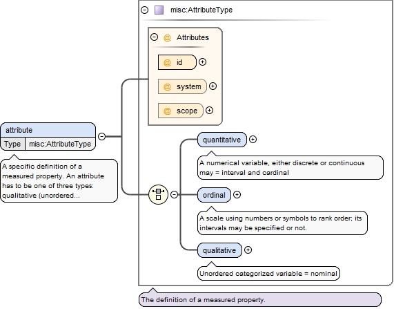
<xsd:element name="attributes" minOccurs="0"><xsd:annotation><xsd:documentation>A container for the definitions of measured properties.</xsd:documentation></xsd:annotation><xsd:complexType><xsd:sequence><xsd:element name="attribute" type="misc:AttributeType" maxOccurs="unbounded"><xsd:annotation><xsd:documentation xml:lang="en">A specific definition of a measured property. An attribute has to be one of three types: qualitative (unordered categorical variable, i.e. nominal), ordinal (ordered list of values) or quantitative (a numerical variable, either discrete or continuous</xsd:documentation></xsd:annotation></xsd:element></xsd:sequence></xsd:complexType></xsd:element>
A specific definition of a measured property. An attribute has to be one of three types: qualitative (unordered categorical variable, i.e. nominal), ordinal (ordered list of values) or quantitative (a numerical variable, either discrete or continuous
<xsd:element name="attribute" type="misc:AttributeType" maxOccurs="unbounded"><xsd:annotation><xsd:documentation xml:lang="en">A specific definition of a measured property. An attribute has to be one of three types: qualitative (unordered categorical variable, i.e. nominal), ordinal (ordered list of values) or quantitative (a numerical variable, either discrete or continuous</xsd:documentation></xsd:annotation></xsd:element>
<xsd:element name="quantitative"><xsd:annotation><xsd:documentation>A numerical variable, either discrete or continuous may = interval and cardinal</xsd:documentation></xsd:annotation><xsd:complexType><xsd:sequence><xsd:element name="methodID" type="xsd:string"><xsd:annotation><xsd:documentation>A reference to a specific method that describes the context for the quantitative attribute.</xsd:documentation></xsd:annotation></xsd:element><xsd:element name="unit" type="xsd:string"><xsd:annotation><xsd:documentation xml:lang="en">Unit of measurement (e.g. mm, cm, square meters, number of individuals)</xsd:documentation></xsd:annotation></xsd:element><xsd:element name="precision" type="xsd:decimal" minOccurs="0" maxOccurs="1"><xsd:annotation><xsd:documentation source="http://mdk12.org/instruction/curriculum/mathematics/glossary.shtml" xml:lang="en">The smallest place value to which the measurement is expressed (eg, if pi is represented as 3.14, then its precision is .01).</xsd:documentation></xsd:annotation></xsd:element><xsd:element name="lowerLimit" type="xsd:decimal" minOccurs="0" maxOccurs="1"><xsd:annotation><xsd:documentation xml:lang="en">potential lower limit of the measurement</xsd:documentation></xsd:annotation></xsd:element><xsd:element name="upperLimit" type="xsd:decimal" minOccurs="0" maxOccurs="1"><xsd:annotation><xsd:documentation xml:lang="en">potential upper limit of the measurement</xsd:documentation></xsd:annotation></xsd:element></xsd:sequence></xsd:complexType></xsd:element>
A reference to a specific method that describes the context for the quantitative attribute.
Diagram
Type
xsd:string
Properties
content
simple
Source
<xsd:element name="methodID" type="xsd:string"><xsd:annotation><xsd:documentation>A reference to a specific method that describes the context for the quantitative attribute.</xsd:documentation></xsd:annotation></xsd:element>
Unit of measurement (e.g. mm, cm, square meters, number of individuals)
Diagram
Type
xsd:string
Properties
content
simple
Source
<xsd:element name="unit" type="xsd:string"><xsd:annotation><xsd:documentation xml:lang="en">Unit of measurement (e.g. mm, cm, square meters, number of individuals)</xsd:documentation></xsd:annotation></xsd:element>
The smallest place value to which the measurement is expressed (eg, if pi is represented as 3.14, then its precision is .01).
Diagram
Type
xsd:decimal
Properties
content
simple
minOccurs
0
maxOccurs
1
Source
<xsd:element name="precision" type="xsd:decimal" minOccurs="0" maxOccurs="1"><xsd:annotation><xsd:documentation source="http://mdk12.org/instruction/curriculum/mathematics/glossary.shtml" xml:lang="en">The smallest place value to which the measurement is expressed (eg, if pi is represented as 3.14, then its precision is .01).</xsd:documentation></xsd:annotation></xsd:element>
<xsd:element name="ordinal"><xsd:annotation><xsd:documentation source="http://www.cliffsnotes.com/WileyCDA/Section/Statistics-Glossary.id-305499,articleId-30041.html" xml:lang="en">A scale using numbers or symbols to rank order; its intervals may be specified or not.</xsd:documentation></xsd:annotation><xsd:complexType><xsd:sequence><xsd:element name="methodID" type="xsd:string"><xsd:annotation><xsd:documentation>A reference to a method that describes the context for the ordinal code.</xsd:documentation></xsd:annotation></xsd:element><xsd:element name="code" type="xsd:string"><xsd:annotation><xsd:documentation>Ordinal class code (e.g. a value like "+" or "1" in Braun-Blanquet cover scale)</xsd:documentation></xsd:annotation></xsd:element><xsd:element name="definition" type="xsd:string" minOccurs="0" maxOccurs="1"><xsd:annotation><xsd:documentation>Longer description of the definition of the ordinal class. For example, ">1-5 % percent cover" for code "1" in an ordinal cover scale.</xsd:documentation></xsd:annotation></xsd:element><xsd:element name="lowerLimit" type="xsd:decimal" minOccurs="0"><xsd:annotation><xsd:documentation xml:lang="en">Lower limit of the ordinal class in an associated quantitative scale (e.g. 10% cover in a cover class)</xsd:documentation></xsd:annotation></xsd:element><xsd:element name="upperLimit" type="xsd:decimal" minOccurs="0"><xsd:annotation><xsd:documentation xml:lang="en">Upper limit of the ordinal class in an associated quantitative scale (e.g. 25% cover in a cover class)</xsd:documentation></xsd:annotation></xsd:element><xsd:element name="order" type="xsd:decimal" minOccurs="0"><xsd:annotation><xsd:documentation xml:lang="en">Explicit order in the sequence of ordinal values to which this code belongs.</xsd:documentation></xsd:annotation></xsd:element></xsd:sequence></xsd:complexType></xsd:element>
A reference to a method that describes the context for the ordinal code.
Diagram
Type
xsd:string
Properties
content
simple
Source
<xsd:element name="methodID" type="xsd:string"><xsd:annotation><xsd:documentation>A reference to a method that describes the context for the ordinal code.</xsd:documentation></xsd:annotation></xsd:element>
Ordinal class code (e.g. a value like "+" or "1" in Braun-Blanquet cover scale)
Diagram
Type
xsd:string
Properties
content
simple
Source
<xsd:element name="code" type="xsd:string"><xsd:annotation><xsd:documentation>Ordinal class code (e.g. a value like "+" or "1" in Braun-Blanquet cover scale)</xsd:documentation></xsd:annotation></xsd:element>
Longer description of the definition of the ordinal class. For example, ">1-5 % percent cover" for code "1" in an ordinal cover scale.
Diagram
Type
xsd:string
Properties
content
simple
minOccurs
0
maxOccurs
1
Source
<xsd:element name="definition" type="xsd:string" minOccurs="0" maxOccurs="1"><xsd:annotation><xsd:documentation>Longer description of the definition of the ordinal class. For example, ">1-5 % percent cover" for code "1" in an ordinal cover scale.</xsd:documentation></xsd:annotation></xsd:element>
Lower limit of the ordinal class in an associated quantitative scale (e.g. 10% cover in a cover class)
Diagram
Type
xsd:decimal
Properties
content
simple
minOccurs
0
Source
<xsd:element name="lowerLimit" type="xsd:decimal" minOccurs="0"><xsd:annotation><xsd:documentation xml:lang="en">Lower limit of the ordinal class in an associated quantitative scale (e.g. 10% cover in a cover class)</xsd:documentation></xsd:annotation></xsd:element>
Upper limit of the ordinal class in an associated quantitative scale (e.g. 25% cover in a cover class)
Diagram
Type
xsd:decimal
Properties
content
simple
minOccurs
0
Source
<xsd:element name="upperLimit" type="xsd:decimal" minOccurs="0"><xsd:annotation><xsd:documentation xml:lang="en">Upper limit of the ordinal class in an associated quantitative scale (e.g. 25% cover in a cover class)</xsd:documentation></xsd:annotation></xsd:element>
Explicit order in the sequence of ordinal values to which this code belongs.
Diagram
Type
xsd:decimal
Properties
content
simple
minOccurs
0
Source
<xsd:element name="order" type="xsd:decimal" minOccurs="0"><xsd:annotation><xsd:documentation xml:lang="en">Explicit order in the sequence of ordinal values to which this code belongs.</xsd:documentation></xsd:annotation></xsd:element>
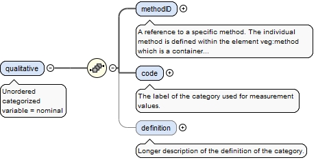
<xsd:element name="qualitative"><xsd:annotation><xsd:documentation>Unordered categorized variable = nominal</xsd:documentation></xsd:annotation><xsd:complexType><xsd:sequence><xsd:element name="methodID" type="xsd:string"><xsd:annotation><xsd:documentation>A reference to a specific method. The individual method is defined within the element veg:method which is a container for all methods within the dataset.</xsd:documentation></xsd:annotation></xsd:element><xsd:element name="code" type="xsd:string"><xsd:annotation><xsd:documentation>The label of the category used for measurement values.</xsd:documentation></xsd:annotation></xsd:element><xsd:element name="definition" type="xsd:string" minOccurs="0" maxOccurs="1"><xsd:annotation><xsd:documentation>Longer description of the definition of the category.</xsd:documentation></xsd:annotation></xsd:element></xsd:sequence></xsd:complexType></xsd:element>
A reference to a specific method. The individual method is defined within the element veg:method which is a container for all methods within the dataset.
Diagram
Type
xsd:string
Properties
content
simple
Source
<xsd:element name="methodID" type="xsd:string"><xsd:annotation><xsd:documentation>A reference to a specific method. The individual method is defined within the element veg:method which is a container for all methods within the dataset.</xsd:documentation></xsd:annotation></xsd:element>
The label of the category used for measurement values.
Diagram
Type
xsd:string
Properties
content
simple
Source
<xsd:element name="code" type="xsd:string"><xsd:annotation><xsd:documentation>The label of the category used for measurement values.</xsd:documentation></xsd:annotation></xsd:element>
Longer description of the definition of the category.
Diagram
Type
xsd:string
Properties
content
simple
minOccurs
0
maxOccurs
1
Source
<xsd:element name="definition" type="xsd:string" minOccurs="0" maxOccurs="1"><xsd:annotation><xsd:documentation>Longer description of the definition of the category.</xsd:documentation></xsd:annotation></xsd:element>
<xsd:element name="strata" minOccurs="0"><xsd:annotation><xsd:documentation>A container for the definitions of strata, following a specific definition method.</xsd:documentation></xsd:annotation><xsd:complexType><xsd:sequence><xsd:element name="stratum" type="plot:StratumType" maxOccurs="unbounded"><xsd:annotation><xsd:documentation xml:lang="en">The specific definition of a stratum referred to by observations in the dataset. A stratum usually belongs to a ordered list that together are the set of strata definitions in use in a specific dataset. It contains the stratum name (e.g. tree layer) as well as an identification code. It may also contain an indication of a position in an ordered sequence of strata.</xsd:documentation></xsd:annotation></xsd:element></xsd:sequence></xsd:complexType></xsd:element>
The specific definition of a stratum referred to by observations in the dataset. A stratum usually belongs to a ordered list that together are the set of strata definitions in use in a specific dataset. It contains the stratum name (e.g. tree layer) as well as an identification code. It may also contain an indication of a position in an ordered sequence of strata.
<xsd:element name="stratum" type="plot:StratumType" maxOccurs="unbounded"><xsd:annotation><xsd:documentation xml:lang="en">The specific definition of a stratum referred to by observations in the dataset. A stratum usually belongs to a ordered list that together are the set of strata definitions in use in a specific dataset. It contains the stratum name (e.g. tree layer) as well as an identification code. It may also contain an indication of a position in an ordered sequence of strata.</xsd:documentation></xsd:annotation></xsd:element>
Name associated with this stratum and which identifies it.
Diagram
Type
xsd:string
Properties
content
simple
Source
<xsd:element name="stratumName" type="xsd:string"><xsd:annotation><xsd:documentation source="VegBank" xml:lang="en">Name associated with this stratum and which identifies it.</xsd:documentation></xsd:annotation></xsd:element>
A link, by ID, to a specific method used to define this stratum (e.g. Tiers according to Allen (1992)). The same method should be referred to by all stratum elements that share a common stratum definition approach.
Diagram
Type
xsd:string
Properties
content
simple
minOccurs
0
Source
<xsd:element name="methodID" type="xsd:string" minOccurs="0"><xsd:annotation><xsd:documentation xml:lang="en">A link, by ID, to a specific method used to define this stratum (e.g. Tiers according to Allen (1992)). The same method should be referred to by all stratum elements that share a common stratum definition approach.</xsd:documentation></xsd:annotation></xsd:element>
The verbal description of the stratum definition (e.g. "Trees between 2 and 5 m height").
Diagram
Type
xsd:string
Properties
content
simple
minOccurs
0
Source
<xsd:element name="definition" type="xsd:string" minOccurs="0"><xsd:annotation><xsd:documentation source="VegBank" xml:lang="en">The verbal description of the stratum definition (e.g. "Trees between 2 and 5 m height").</xsd:documentation></xsd:annotation></xsd:element>
An indication of a position in an ordered sequence of strata.
Diagram
Type
xsd:integer
Properties
content
simple
minOccurs
0
Source
<xsd:element name="order" type="xsd:integer" minOccurs="0"><xsd:annotation><xsd:documentation xml:lang="en">An indication of a position in an ordered sequence of strata.</xsd:documentation></xsd:annotation></xsd:element>
Upper limit of the stratum in some known dimension (e.g. height) defined in the attribute of the method pointed to by 'methodID'.
Diagram
Type
xsd:decimal
Properties
content
simple
minOccurs
0
maxOccurs
1
Source
<xsd:element name="upperLimit" type="xsd:decimal" minOccurs="0" maxOccurs="1"><xsd:annotation><xsd:documentation>Upper limit of the stratum in some known dimension (e.g. height) defined in the attribute of the method pointed to by 'methodID'.</xsd:documentation></xsd:annotation></xsd:element>
Lower limit of the stratum in some known dimension (e.g. height) defined in the attribute of the method pointed to by 'methodID'.
Diagram
Type
xsd:decimal
Properties
content
simple
minOccurs
0
maxOccurs
1
Source
<xsd:element name="lowerLimit" type="xsd:decimal" minOccurs="0" maxOccurs="1"><xsd:annotation><xsd:documentation>Lower limit of the stratum in some known dimension (e.g. height) defined in the attribute of the method pointed to by 'methodID'.</xsd:documentation></xsd:annotation></xsd:element>
<xsd:element name="surfaceTypes" minOccurs="0" maxOccurs="1"><xsd:annotation><xsd:documentation>A container for surface types, following a specific definition method.</xsd:documentation></xsd:annotation><xsd:complexType><xsd:sequence><xsd:element name="surfaceType" type="plot:SurfaceTypeType" minOccurs="1" maxOccurs="unbounded"><xsd:annotation><xsd:documentation>The definition of a surface type, not the observation of cover on them.</xsd:documentation></xsd:annotation></xsd:element></xsd:sequence></xsd:complexType></xsd:element>
<xsd:element name="surfaceType" type="plot:SurfaceTypeType" minOccurs="1" maxOccurs="unbounded"><xsd:annotation><xsd:documentation>The definition of a surface type, not the observation of cover on them.</xsd:documentation></xsd:annotation></xsd:element>
<xsd:element name="surfaceName" type="xsd:string"><xsd:annotation><xsd:documentation source="VegBank" xml:lang="en">Name associated with this stratum</xsd:documentation></xsd:annotation></xsd:element>
A reference to a specific method used to define this surface cover. The individual method is defined within the element veg:methods which is a container for all methods within the dataset.
Diagram
Type
xsd:string
Properties
content
simple
minOccurs
0
Source
<xsd:element name="methodID" type="xsd:string" minOccurs="0"><xsd:annotation><xsd:documentation xml:lang="en">A reference to a specific method used to define this surface cover. The individual method is defined within the element veg:methods which is a container for all methods within the dataset.</xsd:documentation></xsd:annotation></xsd:element>
<xsd:element name="organismNames" minOccurs="0"><xsd:annotation><xsd:documentation>A container for all organism nomenclatural units defined for use by a dataset.</xsd:documentation></xsd:annotation><xsd:complexType><xsd:sequence><xsd:element name="organismName" type="org:OrganismNameType" maxOccurs="unbounded"><xsd:annotation><xsd:documentation>The name of an organism used in the data set. This will normally be a nomenclatural unit of any rank (order, family, genus, species, subspecies, etc.). If it is a formal scientific name (not necessarily including authority) then the attribute 'taxonName' should be set to true. However, the organism name can be a morphospecies, a field name... cases in which the attribute 'taxonName' should be set to false.</xsd:documentation></xsd:annotation></xsd:element></xsd:sequence></xsd:complexType></xsd:element>
The name of an organism used in the data set. This will normally be a nomenclatural unit of any rank (order, family, genus, species, subspecies, etc.). If it is a formal scientific name (not necessarily including authority) then the attribute 'taxonName' should be set to true. However, the organism name can be a morphospecies, a field name... cases in which the attribute 'taxonName' should be set to false.
Unique internal identifier (key) of the element. This identifier is used elsewhere in a dataset instance to reference this specific element when it is referred to in a repeatable way by other part of the schema.
A flag to identify that the organism name is a taxon name (i.e. a name according to a nomenclature code)
Source
<xsd:element name="organismName" type="org:OrganismNameType" maxOccurs="unbounded"><xsd:annotation><xsd:documentation>The name of an organism used in the data set. This will normally be a nomenclatural unit of any rank (order, family, genus, species, subspecies, etc.). If it is a formal scientific name (not necessarily including authority) then the attribute 'taxonName' should be set to true. However, the organism name can be a morphospecies, a field name... cases in which the attribute 'taxonName' should be set to false.</xsd:documentation></xsd:annotation></xsd:element>
<xsd:element name="taxonConcepts" minOccurs="0"><xsd:annotation><xsd:documentation>A container for all taxon concepts defined for use by a dataset.</xsd:documentation></xsd:annotation><xsd:complexType><xsd:sequence><xsd:element name="taxonConcept" type="org:TaxonConceptType" maxOccurs="unbounded"><xsd:annotation><xsd:documentation>Representation of a taxon concept (i.e., an organism name and the organism description given by an author in a publication). A taxon concept may be referenced in an organism identity as the original concept used by the author of the data set, or it can be referenced in taxonDetermination allowing an organism identity to be mapped to a taxonomic concept by third parties after re-examination.</xsd:documentation></xsd:annotation></xsd:element></xsd:sequence></xsd:complexType></xsd:element>
Representation of a taxon concept (i.e., an organism name and the organism description given by an author in a publication). A taxon concept may be referenced in an organism identity as the original concept used by the author of the data set, or it can be referenced in taxonDetermination allowing an organism identity to be mapped to a taxonomic concept by third parties after re-examination.
Unique internal identifier (key) of the element. This identifier is used elsewhere in a dataset instance to reference this specific element when it is referred to in a repeatable way by other part of the schema.
<xsd:element name="taxonConcept" type="org:TaxonConceptType" maxOccurs="unbounded"><xsd:annotation><xsd:documentation>Representation of a taxon concept (i.e., an organism name and the organism description given by an author in a publication). A taxon concept may be referenced in an organism identity as the original concept used by the author of the data set, or it can be referenced in taxonDetermination allowing an organism identity to be mapped to a taxonomic concept by third parties after re-examination.</xsd:documentation></xsd:annotation></xsd:element>
<xsd:element name="organismNameID" type="xsd:string"><xsd:annotation><xsd:documentation>A link to a specific organism name by ID.</xsd:documentation></xsd:annotation></xsd:element>
A link to a bibliographic reference by ID where the taxon concept is described.
Diagram
Type
xsd:string
Properties
content
simple
Source
<xsd:element name="accordingToCitationID" type="xsd:string"><xsd:annotation><xsd:documentation>A link to a bibliographic reference by ID where the taxon concept is described.</xsd:documentation></xsd:annotation></xsd:element>
<xsd:element name="taxonDeterminations" minOccurs="0"><xsd:annotation><xsd:documentation>A container for relationships or assertions between two concepts.</xsd:documentation></xsd:annotation><xsd:complexType><xsd:sequence><xsd:element name="taxonDetermination" type="org:TaxonDeterminationType" maxOccurs="unbounded"><xsd:annotation><xsd:documentation xml:lang="en">A specific relationship or assertion between two name concepts which are not part of the original definition of either of these concepts; possibly by a third party. Within vegX this typically allows for an organism identity, to be linked to a specific taxa treatment (taxon concept), according to a third party. Similar to a tcs TaxonRelationshipAssertion.</xsd:documentation></xsd:annotation></xsd:element></xsd:sequence></xsd:complexType></xsd:element>
A specific relationship or assertion between two name concepts which are not part of the original definition of either of these concepts; possibly by a third party. Within vegX this typically allows for an organism identity, to be linked to a specific taxa treatment (taxon concept), according to a third party. Similar to a tcs TaxonRelationshipAssertion.
<xsd:element name="taxonDetermination" type="org:TaxonDeterminationType" maxOccurs="unbounded"><xsd:annotation><xsd:documentation xml:lang="en">A specific relationship or assertion between two name concepts which are not part of the original definition of either of these concepts; possibly by a third party. Within vegX this typically allows for an organism identity, to be linked to a specific taxa treatment (taxon concept), according to a third party. Similar to a tcs TaxonRelationshipAssertion.</xsd:documentation></xsd:annotation></xsd:element>
A reference to a specific taxonNameUsageConcept through the NameUsageConcept id attribute. The individual NameUsageConcept is defined within the element veg:datasetNameUsageConcepts which is a container for all name usage concepts within the dataset.
Diagram
Type
xsd:string
Properties
content
simple
Source
<xsd:element name="organismIdentityID" type="xsd:string"><xsd:annotation><xsd:documentation>A reference to a specific taxonNameUsageConcept through the NameUsageConcept id attribute. The individual NameUsageConcept is defined within the element veg:datasetNameUsageConcepts which is a container for all name usage concepts within the dataset.</xsd:documentation></xsd:annotation></xsd:element>
The determination date for the organism or taxon observation. Recorded in ISO 8601 date format: yyyy-mm-dd.
Diagram
Type
xsd:date
Properties
content
simple
minOccurs
0
Source
<xsd:element name="determinationDate" type="xsd:date" minOccurs="0"><xsd:annotation><xsd:documentation xml:lang="en">The determination date for the organism or taxon observation. Recorded in ISO 8601 date format: yyyy-mm-dd.</xsd:documentation></xsd:annotation></xsd:element>
The party that made the determination that applies to this dataset. This is not the same as the authorship of the asserted relationship. See accordingTo.
Diagram
Type
xsd:string
Properties
content
simple
minOccurs
0
maxOccurs
unbounded
Source
<xsd:element xmlns:q2="http://www.bfn.de/misc-1.0.1" name="determinationPartyID" type="xsd:string" minOccurs="0" maxOccurs="unbounded"><xsd:annotation><xsd:documentation>The party that made the determination that applies to this dataset. This is not the same as the authorship of the asserted relationship. See accordingTo.</xsd:documentation></xsd:annotation></xsd:element>
The text of the additional comments or explanations.
Diagram
Type
xsd:string
Properties
content
simple
Source
<xsd:element name="text" type="xsd:string"><xsd:annotation><xsd:documentation xml:lang="en">The text of the additional comments or explanations.</xsd:documentation></xsd:annotation></xsd:element>
The date on which the note was stored in the database. Recorded in ISO 8601 date format: yyyy-mm-dd.
Diagram
Type
xsd:date
Properties
content
simple
minOccurs
0
Source
<xsd:element name="date" type="xsd:date" minOccurs="0"><xsd:annotation><xsd:documentation xml:lang="en">The date on which the note was stored in the database. Recorded in ISO 8601 date format: yyyy-mm-dd.</xsd:documentation></xsd:annotation></xsd:element>
The type of note: Database Management, Observation Author, Database User and Internal.
Diagram
Type
xsd:string
Properties
content
simple
minOccurs
0
Source
<xsd:element name="type" type="xsd:string" minOccurs="0"><xsd:annotation><xsd:documentation source="VegBank">The type of note: Database Management, Observation Author, Database User and Internal.</xsd:documentation></xsd:annotation></xsd:element>
A reference to the specific individual who contributed the note. The identity of the contributor is defined within the element veg:parties [EML] which is a container for all parties within the dataset.
Diagram
Type
xsd:string
Properties
content
simple
minOccurs
0
Source
<xsd:element name="partyID" type="xsd:string" minOccurs="0"><xsd:annotation><xsd:documentation xml:lang="en">A reference to the specific individual who contributed the note. The identity of the contributor is defined within the element veg:parties [EML] which is a container for all parties within the dataset.</xsd:documentation></xsd:annotation></xsd:element>
<xsd:element name="taxonRelationshipAssertion" maxOccurs="unbounded"><xsd:annotation><xsd:documentation xml:lang="en">A specific taxonomic or nomenclatural assertion record.</xsd:documentation></xsd:annotation><xsd:complexType><xsd:sequence><xsd:element name="assertion"><xsd:annotation><xsd:documentation xml:lang="en">A taxonomic or nomenclatural assertion to either a published nomenclatural name (taxon name) or a specific taxa treatment (taxon concept), according to a third party.</xsd:documentation></xsd:annotation><xsd:complexType><xsd:choice><xsd:element name="organismNameID" type="xsd:string"><xsd:annotation><xsd:documentation>A reference to a specific Taxon Name. The name is defined within the element veg:organismName which is a container for all Taxon Names within a dataset.</xsd:documentation></xsd:annotation></xsd:element><xsd:element name="taxonConceptID" type="xsd:string"><xsd:annotation><xsd:documentation>A reference to a specific Taxon Concept. The concept is defined within the element veg:taxonConcept which is a container for all Taxon Concepts within a dataset.</xsd:documentation></xsd:annotation></xsd:element></xsd:choice></xsd:complexType></xsd:element><xsd:element name="fit" type="xsd:string" minOccurs="0"><xsd:annotation><xsd:documentation>Indicates the degree of fit with the concept being assigned.</xsd:documentation></xsd:annotation></xsd:element><xsd:element name="confidence" type="xsd:string" minOccurs="0"><xsd:annotation><xsd:documentation>Indicates the degree of confidence of the interpreter(s) in the interpretation made. This can reflect the level of familiarity with the classification or the sufficiency of information about the plot (e.g., High, Moderate, Low).</xsd:documentation></xsd:annotation></xsd:element><xsd:element name="accordingTo" type="xsd:string" minOccurs="0"><xsd:annotation><xsd:documentation>Information about the authorship of the asserted relationship.</xsd:documentation></xsd:annotation></xsd:element></xsd:sequence></xsd:complexType></xsd:element>
A taxonomic or nomenclatural assertion to either a published nomenclatural name (taxon name) or a specific taxa treatment (taxon concept), according to a third party.
<xsd:element name="assertion"><xsd:annotation><xsd:documentation xml:lang="en">A taxonomic or nomenclatural assertion to either a published nomenclatural name (taxon name) or a specific taxa treatment (taxon concept), according to a third party.</xsd:documentation></xsd:annotation><xsd:complexType><xsd:choice><xsd:element name="organismNameID" type="xsd:string"><xsd:annotation><xsd:documentation>A reference to a specific Taxon Name. The name is defined within the element veg:organismName which is a container for all Taxon Names within a dataset.</xsd:documentation></xsd:annotation></xsd:element><xsd:element name="taxonConceptID" type="xsd:string"><xsd:annotation><xsd:documentation>A reference to a specific Taxon Concept. The concept is defined within the element veg:taxonConcept which is a container for all Taxon Concepts within a dataset.</xsd:documentation></xsd:annotation></xsd:element></xsd:choice></xsd:complexType></xsd:element>
A reference to a specific Taxon Name. The name is defined within the element veg:organismName which is a container for all Taxon Names within a dataset.
Diagram
Type
xsd:string
Properties
content
simple
Source
<xsd:element name="organismNameID" type="xsd:string"><xsd:annotation><xsd:documentation>A reference to a specific Taxon Name. The name is defined within the element veg:organismName which is a container for all Taxon Names within a dataset.</xsd:documentation></xsd:annotation></xsd:element>
A reference to a specific Taxon Concept. The concept is defined within the element veg:taxonConcept which is a container for all Taxon Concepts within a dataset.
Diagram
Type
xsd:string
Properties
content
simple
Source
<xsd:element name="taxonConceptID" type="xsd:string"><xsd:annotation><xsd:documentation>A reference to a specific Taxon Concept. The concept is defined within the element veg:taxonConcept which is a container for all Taxon Concepts within a dataset.</xsd:documentation></xsd:annotation></xsd:element>
Indicates the degree of fit with the concept being assigned.
Diagram
Type
xsd:string
Properties
content
simple
minOccurs
0
Source
<xsd:element name="fit" type="xsd:string" minOccurs="0"><xsd:annotation><xsd:documentation>Indicates the degree of fit with the concept being assigned.</xsd:documentation></xsd:annotation></xsd:element>
Indicates the degree of confidence of the interpreter(s) in the interpretation made. This can reflect the level of familiarity with the classification or the sufficiency of information about the plot (e.g., High, Moderate, Low).
Diagram
Type
xsd:string
Properties
content
simple
minOccurs
0
Source
<xsd:element name="confidence" type="xsd:string" minOccurs="0"><xsd:annotation><xsd:documentation>Indicates the degree of confidence of the interpreter(s) in the interpretation made. This can reflect the level of familiarity with the classification or the sufficiency of information about the plot (e.g., High, Moderate, Low).</xsd:documentation></xsd:annotation></xsd:element>
Information about the authorship of the asserted relationship.
Diagram
Type
xsd:string
Properties
content
simple
minOccurs
0
Source
<xsd:element name="accordingTo" type="xsd:string" minOccurs="0"><xsd:annotation><xsd:documentation>Information about the authorship of the asserted relationship.</xsd:documentation></xsd:annotation></xsd:element>
<xsd:element name="organismIdentities" minOccurs="0"><xsd:annotation><xsd:documentation>A container for organism identities used within the dataset.</xsd:documentation></xsd:annotation><xsd:complexType><xsd:sequence><xsd:element name="organismIdentity" type="org:OrganismIdentityType" maxOccurs="unbounded"><xsd:annotation><xsd:documentation>The identity of an organism (or a set of organisms) occurring within the dataset.</xsd:documentation></xsd:annotation></xsd:element></xsd:sequence></xsd:complexType></xsd:element>
<xsd:element name="organismIdentity" type="org:OrganismIdentityType" maxOccurs="unbounded"><xsd:annotation><xsd:documentation>The identity of an organism (or a set of organisms) occurring within the dataset.</xsd:documentation></xsd:annotation></xsd:element>
A link, by ID, to an organism name (e.g. normally a taxon name, but not necessarily including the authority, or even field names, morphospecies, ...) that the author of the dataset originally used to refer to an organism observed within the plot. The taxon names used as label the organism identity should not contain spelling errors, but they may not be the accepted name according to current nomenclature codes.
Diagram
Type
xsd:string
Properties
content
simple
Source
<xsd:element name="originalOrganismNameID" type="xsd:string"><xsd:annotation><xsd:documentation xml:lang="en">A link, by ID, to an organism name (e.g. normally a taxon name, but not necessarily including the authority, or even field names, morphospecies, ...) that the author of the dataset originally used to refer to an organism observed within the plot. The taxon names used as label the organism identity should not contain spelling errors, but they may not be the accepted name according to current nomenclature codes.</xsd:documentation></xsd:annotation></xsd:element>
A link to a party involved in the original organism identification (normally the author of the data set), by ID.
Diagram
Type
xsd:string
Properties
content
simple
minOccurs
0
maxOccurs
unbounded
Source
<xsd:element name="originalIdentificationPartyID" type="xsd:string" minOccurs="0" maxOccurs="unbounded"><xsd:annotation><xsd:documentation>A link to a party involved in the original organism identification (normally the author of the data set), by ID.</xsd:documentation></xsd:annotation></xsd:element>
<xsd:element name="originalIdentificationNote" type="misc:noteType" minOccurs="0" maxOccurs="unbounded"><xsd:annotation><xsd:documentation>Additional comments or explanations pertaining to the original identification of the organism.</xsd:documentation></xsd:annotation></xsd:element>
Herbarium accession number for any archived voucher specimens
Diagram
Type
xsd:string
Properties
content
simple
minOccurs
0
maxOccurs
unbounded
Source
<xsd:element name="voucher" type="xsd:string" minOccurs="0" maxOccurs="unbounded"><xsd:annotation><xsd:documentation xml:lang="en">Herbarium accession number for any archived voucher specimens</xsd:documentation></xsd:annotation></xsd:element>
A container of the taxon concept (i.e. taxon name + reference explaining the concept) originally associated to the organism identity. The taxon concept may have been specified by the author of the data set, or it may be asserted by a third party based on information such as date of observation or geographic location.
<xsd:element name="originalIdentificationConcept" minOccurs="0" maxOccurs="1"><xsd:annotation><xsd:documentation>A container of the taxon concept (i.e. taxon name + reference explaining the concept) originally associated to the organism identity. The taxon concept may have been specified by the author of the data set, or it may be asserted by a third party based on information such as date of observation or geographic location.</xsd:documentation></xsd:annotation><xsd:complexType><xsd:sequence><xsd:element name="taxonConceptID" type="xsd:string"><xsd:annotation><xsd:documentation>A link to the taxon concept stated by the author, or as asserted by a third party based on information such as the date of the observation, geographic location, etc.</xsd:documentation></xsd:annotation></xsd:element><xsd:element name="conceptAssertionDate" type="xsd:date" minOccurs="0" maxOccurs="1"><xsd:annotation><xsd:documentation xml:lang="en">Date of the taxon concept assertion. Recorded in ISO 8601 date format: yyyy-mm-dd.</xsd:documentation></xsd:annotation></xsd:element><xsd:element name="conceptAssertionPartyID" type="xsd:string" minOccurs="0" maxOccurs="unbounded"><xsd:annotation><xsd:documentation>A link, by ID, to a party involved in the assertion of the original taxon concept.</xsd:documentation></xsd:annotation></xsd:element><xsd:element name="conceptAssertionNote" type="misc:noteType" minOccurs="0" maxOccurs="unbounded"><xsd:annotation><xsd:documentation>Additional comments or explanations pertaining to the assertion of the original taxon concept.</xsd:documentation></xsd:annotation></xsd:element></xsd:sequence></xsd:complexType></xsd:element>
A link to the taxon concept stated by the author, or as asserted by a third party based on information such as the date of the observation, geographic location, etc.
Diagram
Type
xsd:string
Properties
content
simple
Source
<xsd:element name="taxonConceptID" type="xsd:string"><xsd:annotation><xsd:documentation>A link to the taxon concept stated by the author, or as asserted by a third party based on information such as the date of the observation, geographic location, etc.</xsd:documentation></xsd:annotation></xsd:element>
Date of the taxon concept assertion. Recorded in ISO 8601 date format: yyyy-mm-dd.
Diagram
Type
xsd:date
Properties
content
simple
minOccurs
0
maxOccurs
1
Source
<xsd:element name="conceptAssertionDate" type="xsd:date" minOccurs="0" maxOccurs="1"><xsd:annotation><xsd:documentation xml:lang="en">Date of the taxon concept assertion. Recorded in ISO 8601 date format: yyyy-mm-dd.</xsd:documentation></xsd:annotation></xsd:element>
A link, by ID, to a party involved in the assertion of the original taxon concept.
Diagram
Type
xsd:string
Properties
content
simple
minOccurs
0
maxOccurs
unbounded
Source
<xsd:element name="conceptAssertionPartyID" type="xsd:string" minOccurs="0" maxOccurs="unbounded"><xsd:annotation><xsd:documentation>A link, by ID, to a party involved in the assertion of the original taxon concept.</xsd:documentation></xsd:annotation></xsd:element>
<xsd:element name="conceptAssertionNote" type="misc:noteType" minOccurs="0" maxOccurs="unbounded"><xsd:annotation><xsd:documentation>Additional comments or explanations pertaining to the assertion of the original taxon concept.</xsd:documentation></xsd:annotation></xsd:element>
The interpretation of the nomenclature that should be applied to organism identity, made after the observation event by the author of the data set or a third party. The sub-element preferredTaxonNameID points to an organism name that is the accepted name according to the current nomenclature.
<xsd:element name="preferredTaxonNomenclature" minOccurs="0" maxOccurs="1"><xsd:annotation><xsd:documentation>The interpretation of the nomenclature that should be applied to organism identity, made after the observation event by the author of the data set or a third party. The sub-element preferredTaxonNameID points to an organism name that is the accepted name according to the current nomenclature.</xsd:documentation></xsd:annotation><xsd:complexType><xsd:sequence><xsd:element name="preferredOrganismNameID" type="xsd:string"><xsd:annotation><xsd:documentation>A link to a scientific taxon name (i.e. an organism name whose attribute 'taxonName' is true) accepted to label the organism identity appropriately, as stated by the author of the data set or a third party responsible for its nomenclature.</xsd:documentation></xsd:annotation></xsd:element><xsd:element name="interpretationDate" type="xsd:date" minOccurs="0" maxOccurs="1"><xsd:annotation><xsd:documentation xml:lang="en">Date for the last nomenclature revision applied to this organism identity. Recorded in ISO 8601 date format: yyyy-mm-dd.</xsd:documentation></xsd:annotation></xsd:element><xsd:element name="interpretationSource" type="xsd:string" minOccurs="0" maxOccurs="1"><xsd:annotation><xsd:documentation xml:lang="EN">A string describing the source for the last nomenclature interpretation applied to this organism identity (i.e. the Plant List).</xsd:documentation></xsd:annotation></xsd:element><xsd:element name="interpretationCitationID" type="xsd:string" minOccurs="0" maxOccurs="1"><xsd:annotation><xsd:documentation xml:lang="EN">A link to the publication where nomenclature interpretation is described.</xsd:documentation></xsd:annotation></xsd:element><xsd:element name="interpretationPartyID" type="xsd:string" minOccurs="0" maxOccurs="unbounded"><xsd:annotation><xsd:documentation>A link to a party who undertook the nomenclarure revision.</xsd:documentation></xsd:annotation></xsd:element><xsd:element name="interpretationNote" type="misc:noteType" minOccurs="0" maxOccurs="unbounded"><xsd:annotation><xsd:documentation>Additional comments or explanations pertaining to the nomenclature interpretation.</xsd:documentation></xsd:annotation></xsd:element></xsd:sequence></xsd:complexType></xsd:element>
A link to a scientific taxon name (i.e. an organism name whose attribute 'taxonName' is true) accepted to label the organism identity appropriately, as stated by the author of the data set or a third party responsible for its nomenclature.
Diagram
Type
xsd:string
Properties
content
simple
Source
<xsd:element name="preferredOrganismNameID" type="xsd:string"><xsd:annotation><xsd:documentation>A link to a scientific taxon name (i.e. an organism name whose attribute 'taxonName' is true) accepted to label the organism identity appropriately, as stated by the author of the data set or a third party responsible for its nomenclature.</xsd:documentation></xsd:annotation></xsd:element>
Date for the last nomenclature revision applied to this organism identity. Recorded in ISO 8601 date format: yyyy-mm-dd.
Diagram
Type
xsd:date
Properties
content
simple
minOccurs
0
maxOccurs
1
Source
<xsd:element name="interpretationDate" type="xsd:date" minOccurs="0" maxOccurs="1"><xsd:annotation><xsd:documentation xml:lang="en">Date for the last nomenclature revision applied to this organism identity. Recorded in ISO 8601 date format: yyyy-mm-dd.</xsd:documentation></xsd:annotation></xsd:element>
A string describing the source for the last nomenclature interpretation applied to this organism identity (i.e. the Plant List).
Diagram
Type
xsd:string
Properties
content
simple
minOccurs
0
maxOccurs
1
Source
<xsd:element name="interpretationSource" type="xsd:string" minOccurs="0" maxOccurs="1"><xsd:annotation><xsd:documentation xml:lang="EN">A string describing the source for the last nomenclature interpretation applied to this organism identity (i.e. the Plant List).</xsd:documentation></xsd:annotation></xsd:element>
A link to the publication where nomenclature interpretation is described.
Diagram
Type
xsd:string
Properties
content
simple
minOccurs
0
maxOccurs
1
Source
<xsd:element name="interpretationCitationID" type="xsd:string" minOccurs="0" maxOccurs="1"><xsd:annotation><xsd:documentation xml:lang="EN">A link to the publication where nomenclature interpretation is described.</xsd:documentation></xsd:annotation></xsd:element>
A link to a party who undertook the nomenclarure revision.
Diagram
Type
xsd:string
Properties
content
simple
minOccurs
0
maxOccurs
unbounded
Source
<xsd:element name="interpretationPartyID" type="xsd:string" minOccurs="0" maxOccurs="unbounded"><xsd:annotation><xsd:documentation>A link to a party who undertook the nomenclarure revision.</xsd:documentation></xsd:annotation></xsd:element>
<xsd:element name="interpretationNote" type="misc:noteType" minOccurs="0" maxOccurs="unbounded"><xsd:annotation><xsd:documentation>Additional comments or explanations pertaining to the nomenclature interpretation.</xsd:documentation></xsd:annotation></xsd:element>
<xsd:element name="communityConcepts" minOccurs="0" maxOccurs="1"><xsd:annotation><xsd:documentation>A container for community concepts, i.e. names of plant community types and preferably references that help to define the types.</xsd:documentation></xsd:annotation><xsd:complexType><xsd:sequence><xsd:element name="communityConcept" type="comm:CommunityConceptType" minOccurs="1" maxOccurs="unbounded"><xsd:annotation><xsd:documentation xml:lang="EN">A name of a plant community type, preferably together with a reference that helps to define the type.</xsd:documentation></xsd:annotation></xsd:element></xsd:sequence></xsd:complexType></xsd:element>
<xsd:element name="communityConcept" type="comm:CommunityConceptType" minOccurs="1" maxOccurs="unbounded"><xsd:annotation><xsd:documentation xml:lang="EN">A name of a plant community type, preferably together with a reference that helps to define the type.</xsd:documentation></xsd:annotation></xsd:element>
A textual label for a community type. Community types represent recurring assemblages of plant species. They may be designated by syntaxa or physiognomic types.
Diagram
Type
xsd:string
Properties
content
simple
Source
<xsd:element name="name" type="xsd:string"><xsd:annotation><xsd:documentation xml:lang="en">A textual label for a community type. Community types represent recurring assemblages of plant species. They may be designated by syntaxa or physiognomic types.</xsd:documentation></xsd:annotation></xsd:element>
<xsd:element name="communityDeterminations" minOccurs="0"><xsd:annotation><xsd:documentation>A container for identifications that apply one or more CommunityConcepts to a PlotObservation by a Party.</xsd:documentation></xsd:annotation><xsd:complexType><xsd:sequence><xsd:element name="communityDetermination" type="comm:CommunityDeterminationType" maxOccurs="unbounded"><xsd:annotation><xsd:documentation xml:lang="en">An application of one or more communityConcepts to a plotObservation.</xsd:documentation></xsd:annotation></xsd:element></xsd:sequence></xsd:complexType></xsd:element>
<xsd:element name="communityDetermination" type="comm:CommunityDeterminationType" maxOccurs="unbounded"><xsd:annotation><xsd:documentation xml:lang="en">An application of one or more communityConcepts to a plotObservation.</xsd:documentation></xsd:annotation></xsd:element>
A reference to a specific plotObservation. The individual plotObservation is defined within the element veg:plotObservations which is a container for all plotObservations within the dataset.
Diagram
Type
xsd:string
Properties
content
simple
Source
<xsd:element name="plotObservationID" type="xsd:string"><xsd:annotation><xsd:documentation>A reference to a specific plotObservation. The individual plotObservation is defined within the element veg:plotObservations which is a container for all plotObservations within the dataset.</xsd:documentation></xsd:annotation></xsd:element>
A reference to a specific stratumObservation. This element may be used to specify that the community determination applies to a specific stratum.
Diagram
Type
xsd:string
Properties
content
simple
minOccurs
0
maxOccurs
1
Source
<xsd:element name="stratumObservationID" type="xsd:string" minOccurs="0" maxOccurs="1"><xsd:annotation><xsd:documentation>A reference to a specific stratumObservation. This element may be used to specify that the community determination applies to a specific stratum.</xsd:documentation></xsd:annotation></xsd:element>
The start date of this specific community determination. Recorded in ISO 8601 date format: yyyy-mm-dd.
Diagram
Type
xsd:date
Properties
content
simple
minOccurs
0
maxOccurs
1
Source
<xsd:element name="determinationDate" type="xsd:date" minOccurs="0" maxOccurs="1"><xsd:annotation><xsd:documentation source="NVS" xml:lang="en">The start date of this specific community determination. Recorded in ISO 8601 date format: yyyy-mm-dd.</xsd:documentation></xsd:annotation></xsd:element>
<xsd:element name="determinationPartyID" type="xsd:string" minOccurs="0" maxOccurs="unbounded"><xsd:annotation><xsd:documentation>A link to the community determination party by ID</xsd:documentation></xsd:annotation></xsd:element>
<xsd:element name="communityRelationshipAssertion" maxOccurs="unbounded"><xsd:annotation><xsd:documentation xml:lang="en">A container for applying one or more communityConcepts to a plotObservation</xsd:documentation></xsd:annotation><xsd:complexType><xsd:sequence><xsd:element name="communityConceptID" type="xsd:string"><xsd:annotation><xsd:documentation xml:lang="en">A link to a community concept by ID.</xsd:documentation></xsd:annotation></xsd:element><xsd:element name="fit" type="xsd:string" minOccurs="0"><xsd:annotation><xsd:documentation source="VegBank" xml:lang="en">Indicates the degree of fit with the community concept being assigned. Values derive from Gopal, S., and Woodcock, C. (1994), Theory and methods for accuracy assessment of thematic maps using fuzzy sets. Photogrammetric Engineering and Remote Sensing 60(2):181-188.</xsd:documentation></xsd:annotation></xsd:element><xsd:element name="confidence" type="xsd:string" minOccurs="0"><xsd:annotation><xsd:documentation source="VegBank" xml:lang="en">Indicates the degree of confidence of the interpreter(s) in the interpretation made. This can reflect the level of familiarity with the classification or the sufficiency of information about the plot (e.g., High, Moderate, Low).</xsd:documentation></xsd:annotation></xsd:element><xsd:element name="accordingTo" type="xsd:string" minOccurs="0"><xsd:annotation><xsd:documentation>Information about the authorship of the asserted community concept.</xsd:documentation></xsd:annotation></xsd:element></xsd:sequence></xsd:complexType></xsd:element>
<xsd:element name="communityConceptID" type="xsd:string"><xsd:annotation><xsd:documentation xml:lang="en">A link to a community concept by ID.</xsd:documentation></xsd:annotation></xsd:element>
Indicates the degree of fit with the community concept being assigned. Values derive from Gopal, S., and Woodcock, C. (1994), Theory and methods for accuracy assessment of thematic maps using fuzzy sets. Photogrammetric Engineering and Remote Sensing 60(2):181-188.
Diagram
Type
xsd:string
Properties
content
simple
minOccurs
0
Source
<xsd:element name="fit" type="xsd:string" minOccurs="0"><xsd:annotation><xsd:documentation source="VegBank" xml:lang="en">Indicates the degree of fit with the community concept being assigned. Values derive from Gopal, S., and Woodcock, C. (1994), Theory and methods for accuracy assessment of thematic maps using fuzzy sets. Photogrammetric Engineering and Remote Sensing 60(2):181-188.</xsd:documentation></xsd:annotation></xsd:element>
Indicates the degree of confidence of the interpreter(s) in the interpretation made. This can reflect the level of familiarity with the classification or the sufficiency of information about the plot (e.g., High, Moderate, Low).
Diagram
Type
xsd:string
Properties
content
simple
minOccurs
0
Source
<xsd:element name="confidence" type="xsd:string" minOccurs="0"><xsd:annotation><xsd:documentation source="VegBank" xml:lang="en">Indicates the degree of confidence of the interpreter(s) in the interpretation made. This can reflect the level of familiarity with the classification or the sufficiency of information about the plot (e.g., High, Moderate, Low).</xsd:documentation></xsd:annotation></xsd:element>
Information about the authorship of the asserted community concept.
Diagram
Type
xsd:string
Properties
content
simple
minOccurs
0
Source
<xsd:element name="accordingTo" type="xsd:string" minOccurs="0"><xsd:annotation><xsd:documentation>Information about the authorship of the asserted community concept.</xsd:documentation></xsd:annotation></xsd:element>
<xsd:element name="projects" minOccurs="0"><xsd:annotation><xsd:documentation>A container for projects.</xsd:documentation></xsd:annotation><xsd:complexType><xsd:sequence><xsd:element name="project" type="misc:projectType" maxOccurs="unbounded"><xsd:annotation><xsd:documentation source="EML" xml:lang="en">Describes the research context in which the dataset was created, including descriptions of over-all motivations and goals, funding, personnel, description of the study area etc. Sub-element definitions were taken from Ecological Markup Language (EML).</xsd:documentation></xsd:annotation></xsd:element></xsd:sequence></xsd:complexType></xsd:element>
Describes the research context in which the dataset was created, including descriptions of over-all motivations and goals, funding, personnel, description of the study area etc. Sub-element definitions were taken from Ecological Markup Language (EML).
Unique internal identifier (key) of the element. This identifier is used elsewhere in a dataset instance to reference this specific element when it is referred to in a repeatable way by other part of the schema.
<xsd:element name="project" type="misc:projectType" maxOccurs="unbounded"><xsd:annotation><xsd:documentation source="EML" xml:lang="en">Describes the research context in which the dataset was created, including descriptions of over-all motivations and goals, funding, personnel, description of the study area etc. Sub-element definitions were taken from Ecological Markup Language (EML).</xsd:documentation></xsd:annotation></xsd:element>
<xsd:element name="title" type="xsd:string"><xsd:annotation><xsd:documentation>Title of the project.</xsd:documentation></xsd:annotation></xsd:element>
<xsd:element name="personnel" type="partyWithRoleType" minOccurs="0" maxOccurs="unbounded"><xsd:annotation><xsd:documentation>Contact and role information for people involved in the research project.</xsd:documentation></xsd:annotation></xsd:element>
A reference to a specific party. The individual party is defined with the element veg:partys which is a container for all the parties within the dataset.
Diagram
Type
xsd:string
Properties
content
simple
Source
<xsd:element name="partyID" type="xsd:string"><xsd:annotation><xsd:documentation xml:lang="en">A reference to a specific party. The individual party is defined with the element veg:partys which is a container for all the parties within the dataset.</xsd:documentation></xsd:annotation></xsd:element>
Based on the the eml-party module - The role code field provides information on how a person or organization is related to a resource.
Diagram
Type
xsd:string
Properties
content
simple
Source
<xsd:element name="role" type="xsd:string"><xsd:annotation><xsd:documentation xml:lang="en">Based on the the eml-party module - The role code field provides information on how a person or organization is related to a resource.</xsd:documentation></xsd:annotation></xsd:element>
A brief description of the aims and findings of the project.
Diagram
Type
xsd:string
Properties
content
simple
minOccurs
0
maxOccurs
1
Source
<xsd:element name="abstract" type="xsd:string" minOccurs="0" maxOccurs="1"><xsd:annotation><xsd:documentation>A brief description of the aims and findings of the project.</xsd:documentation></xsd:annotation></xsd:element>
Description of the physical area associated with the research project, potentially including coverage, climate, geology, distrubances, etc.
Diagram
Type
xsd:string
Properties
content
simple
minOccurs
0
maxOccurs
1
Source
<xsd:element name="studyAreaDescription" type="xsd:string" minOccurs="0" maxOccurs="1"><xsd:annotation><xsd:documentation>Description of the physical area associated with the research project, potentially including coverage, climate, geology, distrubances, etc.</xsd:documentation></xsd:annotation></xsd:element>
Description of the design of the research project (specially overall plot placement).
Diagram
Type
xsd:string
Properties
content
simple
minOccurs
0
maxOccurs
1
Source
<xsd:element name="designDescription" type="xsd:string" minOccurs="0" maxOccurs="1"><xsd:annotation><xsd:documentation>Description of the design of the research project (specially overall plot placement).</xsd:documentation></xsd:annotation></xsd:element>
<xsd:element name="relatedProjectID" type="xsd:string" minOccurs="0" maxOccurs="unbounded"><xsd:annotation><xsd:documentation>A link to another project, by ID.</xsd:documentation></xsd:annotation></xsd:element>
A link, by ID, to the citation of a document describing the project.
Diagram
Type
xsd:string
Properties
content
simple
minOccurs
0
maxOccurs
unbounded
Source
<xsd:element name="documentCitationID" type="xsd:string" minOccurs="0" maxOccurs="unbounded"><xsd:annotation><xsd:documentation>A link, by ID, to the citation of a document describing the project.</xsd:documentation></xsd:annotation></xsd:element>
<xsd:element name="plots" minOccurs="0"><xsd:annotation><xsd:documentation>A container for sampling locations (plots).</xsd:documentation></xsd:annotation><xsd:complexType><xsd:sequence><xsd:element name="plot" type="plot:PlotType" maxOccurs="unbounded"><xsd:annotation><xsd:documentation xml:lang="en">A plot is a sampling location, represented as one or more points, lines, polygons, or volumes, and is the basis for experimentation or measurement. Its properties, like the position, are assumed to be constant on time scales commonly used for direct observations. Plots may have no explicit bounds, and may refer to an area of inference. A plot may be related to other plots in order to express parent-child, contiguity, or other type of spatial links. A point within the plot may be used as reference for relative coordinates.</xsd:documentation></xsd:annotation></xsd:element></xsd:sequence></xsd:complexType></xsd:element>
A plot is a sampling location, represented as one or more points, lines, polygons, or volumes, and is the basis for experimentation or measurement. Its properties, like the position, are assumed to be constant on time scales commonly used for direct observations. Plots may have no explicit bounds, and may refer to an area of inference. A plot may be related to other plots in order to express parent-child, contiguity, or other type of spatial links. A point within the plot may be used as reference for relative coordinates.
Unique internal identifier (key) of the element. This identifier is used elsewhere in a dataset instance to reference this specific element when it is referred to in a repeatable way by other part of the schema.
<xsd:element name="plot" type="plot:PlotType" maxOccurs="unbounded"><xsd:annotation><xsd:documentation xml:lang="en">A plot is a sampling location, represented as one or more points, lines, polygons, or volumes, and is the basis for experimentation or measurement. Its properties, like the position, are assumed to be constant on time scales commonly used for direct observations. Plots may have no explicit bounds, and may refer to an area of inference. A plot may be related to other plots in order to express parent-child, contiguity, or other type of spatial links. A point within the plot may be used as reference for relative coordinates.</xsd:documentation></xsd:annotation></xsd:element>
<xsd:element name="plotName" type="xsd:string"><xsd:annotation><xsd:documentation xml:lang="en">Name or label for a plot.</xsd:documentation></xsd:annotation></xsd:element>
Plot identifier that is unique across the dataset and derived from the data source, and preferably globally unique. A GUID (globally unique identifier) would be ideal for this purpose, such as LSID (Life Science Identifier).
Diagram
Type
xsd:string
Properties
content
simple
minOccurs
0
Source
<xsd:element name="plotUniqueIdentifier" type="xsd:string" minOccurs="0"><xsd:annotation><xsd:documentation xml:lang="en">Plot identifier that is unique across the dataset and derived from the data source, and preferably globally unique. A GUID (globally unique identifier) would be ideal for this purpose, such as LSID (Life Science Identifier).</xsd:documentation></xsd:annotation></xsd:element>
<xsd:element name="relatedPlot" type="relatedPlotType" minOccurs="0" maxOccurs="unbounded"><xsd:annotation><xsd:documentation>A plot may be related spatially to other plots in order to express parent-child, sub-plot or contiguity.</xsd:documentation></xsd:annotation></xsd:element>
A reference to a specific related plot. This would be the parent plot identifer in most cases.
Diagram
Type
xsd:string
Properties
content
simple
Source
<xsd:element name="relatedPlotID" type="xsd:string"><xsd:annotation><xsd:documentation xml:lang="en">A reference to a specific related plot. This would be the parent plot identifer in most cases.</xsd:documentation></xsd:annotation></xsd:element>
The type of relationship of the current plot with respect to the referenced plot. For a parent-child relationship the relatedPlotType should appear in the subplot and plotRelationship should be 'subplot'. For contiguous plots in a transect both plots should have a relatedPlotType and the value of plotRelationship should be 'contiguous'.
Diagram
Type
xsd:string
Properties
content
simple
Source
<xsd:element name="plotRelationship" type="xsd:string"><xsd:annotation><xsd:documentation xml:lang="en">The type of relationship of the current plot with respect to the referenced plot. For a parent-child relationship the relatedPlotType should appear in the subplot and plotRelationship should be 'subplot'. For contiguous plots in a transect both plots should have a relatedPlotType and the value of plotRelationship should be 'contiguous'.</xsd:documentation></xsd:annotation></xsd:element>
Two related plots may have their relative positions described in geometric space using the relative position with respect to the point of origin for the referenced plot.
<xsd:element name="relativeSpatialCoordinate" type="misc:relativeSpatialCoordinateType" minOccurs="0"><xsd:annotation><xsd:documentation>Two related plots may have their relative positions described in geometric space using the relative position with respect to the point of origin for the referenced plot.</xsd:documentation></xsd:annotation></xsd:element>
The X-coordinate of the related items position in meters. The user will enter the relative position of related item with respect to the plot origin (in meters) with the x-axis defined by the plot azimuth.
Diagram
Type
xsd:decimal
Properties
content
simple
Source
<xsd:element name="relativeX" type="xsd:decimal"><xsd:annotation><xsd:documentation source="VegBank" xml:lang="en">The X-coordinate of the related items position in meters. The user will enter the relative position of related item with respect to the plot origin (in meters) with the x-axis defined by the plot azimuth.</xsd:documentation></xsd:annotation></xsd:element>
The Y-coordinate of the related items position in metres. The user will enter the relative position of related item with respect to the plot origin (in meters) with the y-axis defined by the plot azimuth.
Diagram
Type
xsd:decimal
Properties
content
simple
Source
<xsd:element name="relativeY" type="xsd:decimal"><xsd:annotation><xsd:documentation source="VegBank" xml:lang="en">The Y-coordinate of the related items position in metres. The user will enter the relative position of related item with respect to the plot origin (in meters) with the y-axis defined by the plot azimuth.</xsd:documentation></xsd:annotation></xsd:element>
The Z-coordinate of the related items position in metres. The user will enter the relative position of related item with respect to the plot origin (in meters) with the z-axis defined by the plot azimuth.
Diagram
Type
xsd:decimal
Properties
content
simple
minOccurs
0
Source
<xsd:element name="relativeZ" type="xsd:decimal" minOccurs="0"><xsd:annotation><xsd:documentation xml:lang="en">The Z-coordinate of the related items position in metres. The user will enter the relative position of related item with respect to the plot origin (in meters) with the z-axis defined by the plot azimuth.</xsd:documentation></xsd:annotation></xsd:element>
Strategy followed when placing this particular plot. Useful for example if different sampling strategies have been followed within one project.
Diagram
Type
xsd:string
Properties
content
simple
minOccurs
0
Source
<xsd:element name="placementMethod" type="xsd:string" minOccurs="0"><xsd:annotation><xsd:documentation source="VegBank" xml:lang="en">Strategy followed when placing this particular plot. Useful for example if different sampling strategies have been followed within one project.</xsd:documentation></xsd:annotation></xsd:element>
The party that undertook the plot placement, and/or parties with other roles.
Diagram
Type
xsd:string
Properties
content
simple
minOccurs
0
maxOccurs
unbounded
Source
<xsd:element name="placementPartyID" type="xsd:string" minOccurs="0" maxOccurs="unbounded"><xsd:annotation><xsd:documentation>The party that undertook the plot placement, and/or parties with other roles.</xsd:documentation></xsd:annotation></xsd:element>
<xsd:element name="location" minOccurs="0" maxOccurs="1"><xsd:annotation><xsd:documentation>Information regarding the location of a plot on the earth's surface</xsd:documentation></xsd:annotation><xsd:complexType><xsd:sequence><xsd:element name="horizontalCoordinates" minOccurs="0" maxOccurs="unbounded"><xsd:annotation><xsd:documentation>Horizontal location of a plot on the Earth's surface. To avoid ambiguity there should be only one coordinate pair for a plot per measurement. However, there may be multiple measurements by different parties or at different times that can be accommodated in the scheme.</xsd:documentation></xsd:annotation><xsd:complexType><xsd:sequence><xsd:element name="coordinates"><xsd:annotation><xsd:documentation>Value specifying easting or longitude of a point</xsd:documentation></xsd:annotation><xsd:complexType><xsd:sequence><xsd:element name="valueX" type="xsd:string"/><xsd:element name="valueY" type="xsd:string"/><xsd:element name="attributeID" type="xsd:string"><xsd:annotation><xsd:documentation>Specifying units and methods. Typical units are: Decimal degrees like 12.993343 S, or -12.993343 or UTM coordinates like 11N 345567 Methods used could be for example the use of global navigation satellite systems or an estimate based on a map. Note that there is a designated field for the accuracy</xsd:documentation></xsd:annotation></xsd:element><xsd:element name="spatialReference" type="xsd:string"><xsd:annotation><xsd:documentation>Reference system for the coordinates. Ideally a Proj.4 string or EPSG code (see http://spatialreference.org/). Could also be an unambiguous name like 'NAD27(CGQ77) / UTM zone 21N' instead of EPSG:2035. The spatial reference typically used by satellite navigation systems today is EPSG:4326.</xsd:documentation></xsd:annotation></xsd:element><xsd:element name="locationAccuracy" type="misc:MeasurementType" minOccurs="0" maxOccurs="unbounded"><xsd:annotation><xsd:documentation>Measure or estimate of accuracy for the coordinates</xsd:documentation></xsd:annotation></xsd:element></xsd:sequence></xsd:complexType></xsd:element><xsd:element name="locationInPlot" type="xsd:string" minOccurs="0" maxOccurs="1"><xsd:annotation><xsd:documentation>Text describing the position of the coordinates within a plot (simply 'plot origin' if an origin is defined in geometry)</xsd:documentation></xsd:annotation></xsd:element><xsd:element name="locationDate" type="xsd:date" minOccurs="0" maxOccurs="1"><xsd:annotation><xsd:documentation>The date when the coordinates have been assessed or measured. This allows for multiple measurements.</xsd:documentation></xsd:annotation></xsd:element><xsd:element name="locationPartyID" type="xsd:string" minOccurs="0" maxOccurs="unbounded"/><xsd:element name="locationSources" type="xsd:string" minOccurs="0" maxOccurs="unbounded"><xsd:annotation><xsd:documentation>Optionally, maps, gazetteers or other resources used to georeference the locality. The content of this concept is meant to be specific enough to allow anyone in the future to use the same resource to georeference the same locality. Example: "USGS 1:24000 Florence Montana Quad".</xsd:documentation></xsd:annotation></xsd:element><xsd:element name="locationNote" type="misc:noteType" minOccurs="0" maxOccurs="unbounded"/></xsd:sequence></xsd:complexType></xsd:element><xsd:element name="verticalCoordinates" minOccurs="0" maxOccurs="unbounded"><xsd:annotation><xsd:documentation>Elevation of the plot in respect to some vertical datum (such as the mean sea level or an elliposid).</xsd:documentation></xsd:annotation><xsd:complexType><xsd:sequence><xsd:element name="elevation"><xsd:annotation><xsd:documentation>Value specifying the elevation of the plot in respect to some vertical datum (such as the mean sea level or an elliposid).</xsd:documentation></xsd:annotation><xsd:complexType><xsd:sequence><xsd:element name="value" type="xsd:decimal"><xsd:annotation><xsd:documentation>Elevation in meters</xsd:documentation></xsd:annotation></xsd:element><xsd:element name="attributeID" type="xsd:string"><xsd:annotation><xsd:documentation>Specifying units and methods. Typically the measures are in meters and relate to the mean sea level or to base heights of an ellipsoid of the Earth. Typical methods are barometric measurements or the interpretation of a map (element elevationSources).</xsd:documentation></xsd:annotation></xsd:element><xsd:element name="elevationSources" type="xsd:string" minOccurs="0" maxOccurs="unbounded"><xsd:annotation><xsd:documentation>Maps or other resources used to determin the elevation.</xsd:documentation></xsd:annotation></xsd:element><xsd:element name="elevationAccuracy" type="misc:MeasurementType" minOccurs="0" maxOccurs="unbounded"><xsd:annotation><xsd:documentation>Measure or estimate of accuracy for the elevation</xsd:documentation></xsd:annotation></xsd:element></xsd:sequence></xsd:complexType></xsd:element><xsd:element name="elevationInPlot" type="xsd:string" minOccurs="0" maxOccurs="unbounded"><xsd:annotation><xsd:documentation>Point of reference in the plot. This could be the uppermost or lowest point or an average or the plot origin as specified in geometry.</xsd:documentation></xsd:annotation></xsd:element><xsd:element name="elevationDate" type="xsd:date" minOccurs="0" maxOccurs="1"><xsd:annotation><xsd:documentation>The date when the elevation has been assessed or measured. This allows for multiple measurements.</xsd:documentation></xsd:annotation></xsd:element><xsd:element name="elevationPartyID" type="xsd:string" minOccurs="0" maxOccurs="unbounded"><xsd:annotation><xsd:documentation>Party who took the measurement or assessed the value</xsd:documentation></xsd:annotation></xsd:element><xsd:element name="elevationNote" type="misc:noteType" minOccurs="0" maxOccurs="unbounded"><xsd:annotation><xsd:documentation>Any notes relating to this elevation value</xsd:documentation></xsd:annotation></xsd:element></xsd:sequence></xsd:complexType></xsd:element><xsd:element name="markers" type="xsd:string" minOccurs="0" maxOccurs="1"><xsd:annotation><xsd:documentation>Information about markers (like magnetic markers or wooden pegs) that help locating the plot. There should also be a description about where in the plot the markers are found (for example in the corners or in the centre).</xsd:documentation></xsd:annotation></xsd:element><xsd:element name="locationInWaterBody" minOccurs="0" maxOccurs="unbounded"><xsd:annotation><xsd:documentation>Location in respect to a water surface or shoreline.</xsd:documentation></xsd:annotation><xsd:complexType><xsd:sequence><xsd:element name="depth"><xsd:annotation><xsd:documentation>Value specifying the depth in meters under a water surface</xsd:documentation></xsd:annotation><xsd:complexType><xsd:sequence><xsd:element name="value" type="xsd:decimal"><xsd:annotation><xsd:documentation>Depth in meters</xsd:documentation></xsd:annotation></xsd:element><xsd:element name="attributeID" type="xsd:string"><xsd:annotation><xsd:documentation>Specifying units and methods. Typically the measures are in meters and relate to the mean water surface level.</xsd:documentation></xsd:annotation></xsd:element><xsd:element name="depthAccuracy" type="misc:MeasurementType" minOccurs="0" maxOccurs="unbounded"><xsd:annotation><xsd:documentation>Measure or estimate of accuracy for the depth</xsd:documentation></xsd:annotation></xsd:element></xsd:sequence></xsd:complexType></xsd:element><xsd:element name="depthInPlot" type="xsd:string" minOccurs="0" maxOccurs="unbounded"><xsd:annotation><xsd:documentation>Point of reference in the plot. This could be the uppermost or lowest point or an average.</xsd:documentation></xsd:annotation></xsd:element><xsd:element name="depthDate" type="xsd:date" minOccurs="0" maxOccurs="1"><xsd:annotation><xsd:documentation>The date when the depth has been assessed or measured. This allows for multiple measurements.</xsd:documentation></xsd:annotation></xsd:element><xsd:element name="depthPartyID" type="xsd:string" minOccurs="0" maxOccurs="unbounded"><xsd:annotation><xsd:documentation>Party who took the measurement</xsd:documentation></xsd:annotation></xsd:element><xsd:element name="depthNote" type="misc:noteType" minOccurs="0" maxOccurs="unbounded"><xsd:annotation><xsd:documentation>Any notes relating to this depth value</xsd:documentation></xsd:annotation></xsd:element><xsd:element name="shoreDistance" type="misc:MeasurementType"><xsd:annotation><xsd:documentation>Closest distance to shore (for aquatic / marine sites)</xsd:documentation></xsd:annotation></xsd:element></xsd:sequence></xsd:complexType></xsd:element><xsd:element name="gridPosition" minOccurs="0" maxOccurs="unbounded"><xsd:annotation><xsd:documentation>Position in a grid such as used for floristic surveys</xsd:documentation></xsd:annotation><xsd:complexType><xsd:sequence><xsd:element name="gridSystem" type="xsd:string"><xsd:annotation><xsd:documentation>Name of the reference grid system</xsd:documentation></xsd:annotation></xsd:element><xsd:element name="gridCell" type="xsd:string"><xsd:annotation><xsd:documentation>Label of the grid cell</xsd:documentation></xsd:annotation></xsd:element><xsd:element name="gridCellQuadrant" type="xsd:string" minOccurs="0"><xsd:annotation><xsd:documentation>Quadrant of a grid cell</xsd:documentation></xsd:annotation></xsd:element></xsd:sequence></xsd:complexType></xsd:element><xsd:element name="authorLocation" type="xsd:string" minOccurs="0"><xsd:annotation><xsd:documentation xml:lang="en">Descriptive note about the location described by the original author.</xsd:documentation></xsd:annotation></xsd:element><xsd:element name="locationNarrative" type="xsd:string" minOccurs="0"><xsd:annotation><xsd:documentation source="VegBank" xml:lang="en">Text description that provides information useful for plot relocation.</xsd:documentation></xsd:annotation></xsd:element><xsd:element name="places" minOccurs="0" maxOccurs="unbounded"><xsd:annotation><xsd:documentation>A collection of named places or geographic regions. Includes elements to indicate what type of place and which place/geo-region schema it was from.</xsd:documentation></xsd:annotation><xsd:complexType><xsd:sequence><xsd:element name="placeName" type="xsd:string"><xsd:annotation><xsd:documentation>A place name, e.g. Germany.</xsd:documentation></xsd:annotation></xsd:element><xsd:element name="placeType" type="xsd:string"><xsd:annotation><xsd:documentation>What type of place name it is e.g. administrative region, country name, city name etc.</xsd:documentation></xsd:annotation></xsd:element><xsd:element name="placeSchema" type="xsd:string" minOccurs="0"><xsd:annotation><xsd:documentation>A place/geo-region schema from which the type and name were derived e.g. ISO country names.</xsd:documentation></xsd:annotation></xsd:element></xsd:sequence></xsd:complexType></xsd:element></xsd:sequence></xsd:complexType></xsd:element>
Horizontal location of a plot on the Earth's surface. To avoid ambiguity there should be only one coordinate pair for a plot per measurement. However, there may be multiple measurements by different parties or at different times that can be accommodated in the scheme.
<xsd:element name="horizontalCoordinates" minOccurs="0" maxOccurs="unbounded"><xsd:annotation><xsd:documentation>Horizontal location of a plot on the Earth's surface. To avoid ambiguity there should be only one coordinate pair for a plot per measurement. However, there may be multiple measurements by different parties or at different times that can be accommodated in the scheme.</xsd:documentation></xsd:annotation><xsd:complexType><xsd:sequence><xsd:element name="coordinates"><xsd:annotation><xsd:documentation>Value specifying easting or longitude of a point</xsd:documentation></xsd:annotation><xsd:complexType><xsd:sequence><xsd:element name="valueX" type="xsd:string"/><xsd:element name="valueY" type="xsd:string"/><xsd:element name="attributeID" type="xsd:string"><xsd:annotation><xsd:documentation>Specifying units and methods. Typical units are: Decimal degrees like 12.993343 S, or -12.993343 or UTM coordinates like 11N 345567 Methods used could be for example the use of global navigation satellite systems or an estimate based on a map. Note that there is a designated field for the accuracy</xsd:documentation></xsd:annotation></xsd:element><xsd:element name="spatialReference" type="xsd:string"><xsd:annotation><xsd:documentation>Reference system for the coordinates. Ideally a Proj.4 string or EPSG code (see http://spatialreference.org/). Could also be an unambiguous name like 'NAD27(CGQ77) / UTM zone 21N' instead of EPSG:2035. The spatial reference typically used by satellite navigation systems today is EPSG:4326.</xsd:documentation></xsd:annotation></xsd:element><xsd:element name="locationAccuracy" type="misc:MeasurementType" minOccurs="0" maxOccurs="unbounded"><xsd:annotation><xsd:documentation>Measure or estimate of accuracy for the coordinates</xsd:documentation></xsd:annotation></xsd:element></xsd:sequence></xsd:complexType></xsd:element><xsd:element name="locationInPlot" type="xsd:string" minOccurs="0" maxOccurs="1"><xsd:annotation><xsd:documentation>Text describing the position of the coordinates within a plot (simply 'plot origin' if an origin is defined in geometry)</xsd:documentation></xsd:annotation></xsd:element><xsd:element name="locationDate" type="xsd:date" minOccurs="0" maxOccurs="1"><xsd:annotation><xsd:documentation>The date when the coordinates have been assessed or measured. This allows for multiple measurements.</xsd:documentation></xsd:annotation></xsd:element><xsd:element name="locationPartyID" type="xsd:string" minOccurs="0" maxOccurs="unbounded"/><xsd:element name="locationSources" type="xsd:string" minOccurs="0" maxOccurs="unbounded"><xsd:annotation><xsd:documentation>Optionally, maps, gazetteers or other resources used to georeference the locality. The content of this concept is meant to be specific enough to allow anyone in the future to use the same resource to georeference the same locality. Example: "USGS 1:24000 Florence Montana Quad".</xsd:documentation></xsd:annotation></xsd:element><xsd:element name="locationNote" type="misc:noteType" minOccurs="0" maxOccurs="unbounded"/></xsd:sequence></xsd:complexType></xsd:element>
<xsd:element name="coordinates"><xsd:annotation><xsd:documentation>Value specifying easting or longitude of a point</xsd:documentation></xsd:annotation><xsd:complexType><xsd:sequence><xsd:element name="valueX" type="xsd:string"/><xsd:element name="valueY" type="xsd:string"/><xsd:element name="attributeID" type="xsd:string"><xsd:annotation><xsd:documentation>Specifying units and methods. Typical units are: Decimal degrees like 12.993343 S, or -12.993343 or UTM coordinates like 11N 345567 Methods used could be for example the use of global navigation satellite systems or an estimate based on a map. Note that there is a designated field for the accuracy</xsd:documentation></xsd:annotation></xsd:element><xsd:element name="spatialReference" type="xsd:string"><xsd:annotation><xsd:documentation>Reference system for the coordinates. Ideally a Proj.4 string or EPSG code (see http://spatialreference.org/). Could also be an unambiguous name like 'NAD27(CGQ77) / UTM zone 21N' instead of EPSG:2035. The spatial reference typically used by satellite navigation systems today is EPSG:4326.</xsd:documentation></xsd:annotation></xsd:element><xsd:element name="locationAccuracy" type="misc:MeasurementType" minOccurs="0" maxOccurs="unbounded"><xsd:annotation><xsd:documentation>Measure or estimate of accuracy for the coordinates</xsd:documentation></xsd:annotation></xsd:element></xsd:sequence></xsd:complexType></xsd:element>
Specifying units and methods. Typical units are: Decimal degrees like 12.993343 S, or -12.993343 or UTM coordinates like 11N 345567 Methods used could be for example the use of global navigation satellite systems or an estimate based on a map. Note that there is a designated field for the accuracy
Diagram
Type
xsd:string
Properties
content
simple
Source
<xsd:element name="attributeID" type="xsd:string"><xsd:annotation><xsd:documentation>Specifying units and methods. Typical units are: Decimal degrees like 12.993343 S, or -12.993343 or UTM coordinates like 11N 345567 Methods used could be for example the use of global navigation satellite systems or an estimate based on a map. Note that there is a designated field for the accuracy</xsd:documentation></xsd:annotation></xsd:element>
Reference system for the coordinates. Ideally a Proj.4 string or EPSG code (see http://spatialreference.org/). Could also be an unambiguous name like 'NAD27(CGQ77) / UTM zone 21N' instead of EPSG:2035. The spatial reference typically used by satellite navigation systems today is EPSG:4326.
Diagram
Type
xsd:string
Properties
content
simple
Source
<xsd:element name="spatialReference" type="xsd:string"><xsd:annotation><xsd:documentation>Reference system for the coordinates. Ideally a Proj.4 string or EPSG code (see http://spatialreference.org/). Could also be an unambiguous name like 'NAD27(CGQ77) / UTM zone 21N' instead of EPSG:2035. The spatial reference typically used by satellite navigation systems today is EPSG:4326.</xsd:documentation></xsd:annotation></xsd:element>
<xsd:element name="locationAccuracy" type="misc:MeasurementType" minOccurs="0" maxOccurs="unbounded"><xsd:annotation><xsd:documentation>Measure or estimate of accuracy for the coordinates</xsd:documentation></xsd:annotation></xsd:element>
The amount or extent of a specified measurement of a quantity. Usually numeric, but may be a code if the attribute is ordinal or qualitative.
Diagram
Type
xsd:string
Properties
content
simple
Source
<xsd:element name="value" type="xsd:string"><xsd:annotation><xsd:documentation source="Webster's dictionary" xml:lang="en">The amount or extent of a specified measurement of a quantity. Usually numeric, but may be a code if the attribute is ordinal or qualitative.</xsd:documentation></xsd:annotation></xsd:element>
Allows a measurement value to be qualified (type, units, method, etc.).
Diagram
Type
xsd:string
Properties
content
simple
Source
<xsd:element name="attributeID" type="xsd:string"><xsd:annotation><xsd:documentation>Allows a measurement value to be qualified (type, units, method, etc.).</xsd:documentation></xsd:annotation></xsd:element>
The closeness of the estimate or measurement to its true (but unknown) value
Diagram
Type
xsd:string
Properties
content
simple
minOccurs
0
Source
<xsd:element name="accuracy" type="xsd:string" minOccurs="0"><xsd:annotation><xsd:documentation source="http://www.geod.nrcan.gc.ca/edu/gloss_e.php" xml:lang="en">The closeness of the estimate or measurement to its true (but unknown) value</xsd:documentation></xsd:annotation></xsd:element>
<xsd:element name="upperValue" type="xsd:string" minOccurs="0"><xsd:annotation><xsd:documentation>An upper value for an uncertain measurement.</xsd:documentation></xsd:annotation></xsd:element>
<xsd:element name="lowerValue" type="xsd:string" minOccurs="0"><xsd:annotation><xsd:documentation>A lower value for an uncertain measurement.</xsd:documentation></xsd:annotation></xsd:element>
Text describing the position of the coordinates within a plot (simply 'plot origin' if an origin is defined in geometry)
Diagram
Type
xsd:string
Properties
content
simple
minOccurs
0
maxOccurs
1
Source
<xsd:element name="locationInPlot" type="xsd:string" minOccurs="0" maxOccurs="1"><xsd:annotation><xsd:documentation>Text describing the position of the coordinates within a plot (simply 'plot origin' if an origin is defined in geometry)</xsd:documentation></xsd:annotation></xsd:element>
The date when the coordinates have been assessed or measured. This allows for multiple measurements.
Diagram
Type
xsd:date
Properties
content
simple
minOccurs
0
maxOccurs
1
Source
<xsd:element name="locationDate" type="xsd:date" minOccurs="0" maxOccurs="1"><xsd:annotation><xsd:documentation>The date when the coordinates have been assessed or measured. This allows for multiple measurements.</xsd:documentation></xsd:annotation></xsd:element>
Optionally, maps, gazetteers or other resources used to georeference the locality. The content of this concept is meant to be specific enough to allow anyone in the future to use the same resource to georeference the same locality. Example: "USGS 1:24000 Florence Montana Quad".
Diagram
Type
xsd:string
Properties
content
simple
minOccurs
0
maxOccurs
unbounded
Source
<xsd:element name="locationSources" type="xsd:string" minOccurs="0" maxOccurs="unbounded"><xsd:annotation><xsd:documentation>Optionally, maps, gazetteers or other resources used to georeference the locality. The content of this concept is meant to be specific enough to allow anyone in the future to use the same resource to georeference the same locality. Example: "USGS 1:24000 Florence Montana Quad".</xsd:documentation></xsd:annotation></xsd:element>
<xsd:element name="verticalCoordinates" minOccurs="0" maxOccurs="unbounded"><xsd:annotation><xsd:documentation>Elevation of the plot in respect to some vertical datum (such as the mean sea level or an elliposid).</xsd:documentation></xsd:annotation><xsd:complexType><xsd:sequence><xsd:element name="elevation"><xsd:annotation><xsd:documentation>Value specifying the elevation of the plot in respect to some vertical datum (such as the mean sea level or an elliposid).</xsd:documentation></xsd:annotation><xsd:complexType><xsd:sequence><xsd:element name="value" type="xsd:decimal"><xsd:annotation><xsd:documentation>Elevation in meters</xsd:documentation></xsd:annotation></xsd:element><xsd:element name="attributeID" type="xsd:string"><xsd:annotation><xsd:documentation>Specifying units and methods. Typically the measures are in meters and relate to the mean sea level or to base heights of an ellipsoid of the Earth. Typical methods are barometric measurements or the interpretation of a map (element elevationSources).</xsd:documentation></xsd:annotation></xsd:element><xsd:element name="elevationSources" type="xsd:string" minOccurs="0" maxOccurs="unbounded"><xsd:annotation><xsd:documentation>Maps or other resources used to determin the elevation.</xsd:documentation></xsd:annotation></xsd:element><xsd:element name="elevationAccuracy" type="misc:MeasurementType" minOccurs="0" maxOccurs="unbounded"><xsd:annotation><xsd:documentation>Measure or estimate of accuracy for the elevation</xsd:documentation></xsd:annotation></xsd:element></xsd:sequence></xsd:complexType></xsd:element><xsd:element name="elevationInPlot" type="xsd:string" minOccurs="0" maxOccurs="unbounded"><xsd:annotation><xsd:documentation>Point of reference in the plot. This could be the uppermost or lowest point or an average or the plot origin as specified in geometry.</xsd:documentation></xsd:annotation></xsd:element><xsd:element name="elevationDate" type="xsd:date" minOccurs="0" maxOccurs="1"><xsd:annotation><xsd:documentation>The date when the elevation has been assessed or measured. This allows for multiple measurements.</xsd:documentation></xsd:annotation></xsd:element><xsd:element name="elevationPartyID" type="xsd:string" minOccurs="0" maxOccurs="unbounded"><xsd:annotation><xsd:documentation>Party who took the measurement or assessed the value</xsd:documentation></xsd:annotation></xsd:element><xsd:element name="elevationNote" type="misc:noteType" minOccurs="0" maxOccurs="unbounded"><xsd:annotation><xsd:documentation>Any notes relating to this elevation value</xsd:documentation></xsd:annotation></xsd:element></xsd:sequence></xsd:complexType></xsd:element>
<xsd:element name="elevation"><xsd:annotation><xsd:documentation>Value specifying the elevation of the plot in respect to some vertical datum (such as the mean sea level or an elliposid).</xsd:documentation></xsd:annotation><xsd:complexType><xsd:sequence><xsd:element name="value" type="xsd:decimal"><xsd:annotation><xsd:documentation>Elevation in meters</xsd:documentation></xsd:annotation></xsd:element><xsd:element name="attributeID" type="xsd:string"><xsd:annotation><xsd:documentation>Specifying units and methods. Typically the measures are in meters and relate to the mean sea level or to base heights of an ellipsoid of the Earth. Typical methods are barometric measurements or the interpretation of a map (element elevationSources).</xsd:documentation></xsd:annotation></xsd:element><xsd:element name="elevationSources" type="xsd:string" minOccurs="0" maxOccurs="unbounded"><xsd:annotation><xsd:documentation>Maps or other resources used to determin the elevation.</xsd:documentation></xsd:annotation></xsd:element><xsd:element name="elevationAccuracy" type="misc:MeasurementType" minOccurs="0" maxOccurs="unbounded"><xsd:annotation><xsd:documentation>Measure or estimate of accuracy for the elevation</xsd:documentation></xsd:annotation></xsd:element></xsd:sequence></xsd:complexType></xsd:element>
Specifying units and methods. Typically the measures are in meters and relate to the mean sea level or to base heights of an ellipsoid of the Earth. Typical methods are barometric measurements or the interpretation of a map (element elevationSources).
Diagram
Type
xsd:string
Properties
content
simple
Source
<xsd:element name="attributeID" type="xsd:string"><xsd:annotation><xsd:documentation>Specifying units and methods. Typically the measures are in meters and relate to the mean sea level or to base heights of an ellipsoid of the Earth. Typical methods are barometric measurements or the interpretation of a map (element elevationSources).</xsd:documentation></xsd:annotation></xsd:element>
Maps or other resources used to determin the elevation.
Diagram
Type
xsd:string
Properties
content
simple
minOccurs
0
maxOccurs
unbounded
Source
<xsd:element name="elevationSources" type="xsd:string" minOccurs="0" maxOccurs="unbounded"><xsd:annotation><xsd:documentation>Maps or other resources used to determin the elevation.</xsd:documentation></xsd:annotation></xsd:element>
<xsd:element name="elevationAccuracy" type="misc:MeasurementType" minOccurs="0" maxOccurs="unbounded"><xsd:annotation><xsd:documentation>Measure or estimate of accuracy for the elevation</xsd:documentation></xsd:annotation></xsd:element>
Point of reference in the plot. This could be the uppermost or lowest point or an average or the plot origin as specified in geometry.
Diagram
Type
xsd:string
Properties
content
simple
minOccurs
0
maxOccurs
unbounded
Source
<xsd:element name="elevationInPlot" type="xsd:string" minOccurs="0" maxOccurs="unbounded"><xsd:annotation><xsd:documentation>Point of reference in the plot. This could be the uppermost or lowest point or an average or the plot origin as specified in geometry.</xsd:documentation></xsd:annotation></xsd:element>
The date when the elevation has been assessed or measured. This allows for multiple measurements.
Diagram
Type
xsd:date
Properties
content
simple
minOccurs
0
maxOccurs
1
Source
<xsd:element name="elevationDate" type="xsd:date" minOccurs="0" maxOccurs="1"><xsd:annotation><xsd:documentation>The date when the elevation has been assessed or measured. This allows for multiple measurements.</xsd:documentation></xsd:annotation></xsd:element>
Party who took the measurement or assessed the value
Diagram
Type
xsd:string
Properties
content
simple
minOccurs
0
maxOccurs
unbounded
Source
<xsd:element name="elevationPartyID" type="xsd:string" minOccurs="0" maxOccurs="unbounded"><xsd:annotation><xsd:documentation>Party who took the measurement or assessed the value</xsd:documentation></xsd:annotation></xsd:element>
Information about markers (like magnetic markers or wooden pegs) that help locating the plot. There should also be a description about where in the plot the markers are found (for example in the corners or in the centre).
Diagram
Type
xsd:string
Properties
content
simple
minOccurs
0
maxOccurs
1
Source
<xsd:element name="markers" type="xsd:string" minOccurs="0" maxOccurs="1"><xsd:annotation><xsd:documentation>Information about markers (like magnetic markers or wooden pegs) that help locating the plot. There should also be a description about where in the plot the markers are found (for example in the corners or in the centre).</xsd:documentation></xsd:annotation></xsd:element>
<xsd:element name="locationInWaterBody" minOccurs="0" maxOccurs="unbounded"><xsd:annotation><xsd:documentation>Location in respect to a water surface or shoreline.</xsd:documentation></xsd:annotation><xsd:complexType><xsd:sequence><xsd:element name="depth"><xsd:annotation><xsd:documentation>Value specifying the depth in meters under a water surface</xsd:documentation></xsd:annotation><xsd:complexType><xsd:sequence><xsd:element name="value" type="xsd:decimal"><xsd:annotation><xsd:documentation>Depth in meters</xsd:documentation></xsd:annotation></xsd:element><xsd:element name="attributeID" type="xsd:string"><xsd:annotation><xsd:documentation>Specifying units and methods. Typically the measures are in meters and relate to the mean water surface level.</xsd:documentation></xsd:annotation></xsd:element><xsd:element name="depthAccuracy" type="misc:MeasurementType" minOccurs="0" maxOccurs="unbounded"><xsd:annotation><xsd:documentation>Measure or estimate of accuracy for the depth</xsd:documentation></xsd:annotation></xsd:element></xsd:sequence></xsd:complexType></xsd:element><xsd:element name="depthInPlot" type="xsd:string" minOccurs="0" maxOccurs="unbounded"><xsd:annotation><xsd:documentation>Point of reference in the plot. This could be the uppermost or lowest point or an average.</xsd:documentation></xsd:annotation></xsd:element><xsd:element name="depthDate" type="xsd:date" minOccurs="0" maxOccurs="1"><xsd:annotation><xsd:documentation>The date when the depth has been assessed or measured. This allows for multiple measurements.</xsd:documentation></xsd:annotation></xsd:element><xsd:element name="depthPartyID" type="xsd:string" minOccurs="0" maxOccurs="unbounded"><xsd:annotation><xsd:documentation>Party who took the measurement</xsd:documentation></xsd:annotation></xsd:element><xsd:element name="depthNote" type="misc:noteType" minOccurs="0" maxOccurs="unbounded"><xsd:annotation><xsd:documentation>Any notes relating to this depth value</xsd:documentation></xsd:annotation></xsd:element><xsd:element name="shoreDistance" type="misc:MeasurementType"><xsd:annotation><xsd:documentation>Closest distance to shore (for aquatic / marine sites)</xsd:documentation></xsd:annotation></xsd:element></xsd:sequence></xsd:complexType></xsd:element>
<xsd:element name="depth"><xsd:annotation><xsd:documentation>Value specifying the depth in meters under a water surface</xsd:documentation></xsd:annotation><xsd:complexType><xsd:sequence><xsd:element name="value" type="xsd:decimal"><xsd:annotation><xsd:documentation>Depth in meters</xsd:documentation></xsd:annotation></xsd:element><xsd:element name="attributeID" type="xsd:string"><xsd:annotation><xsd:documentation>Specifying units and methods. Typically the measures are in meters and relate to the mean water surface level.</xsd:documentation></xsd:annotation></xsd:element><xsd:element name="depthAccuracy" type="misc:MeasurementType" minOccurs="0" maxOccurs="unbounded"><xsd:annotation><xsd:documentation>Measure or estimate of accuracy for the depth</xsd:documentation></xsd:annotation></xsd:element></xsd:sequence></xsd:complexType></xsd:element>
Specifying units and methods. Typically the measures are in meters and relate to the mean water surface level.
Diagram
Type
xsd:string
Properties
content
simple
Source
<xsd:element name="attributeID" type="xsd:string"><xsd:annotation><xsd:documentation>Specifying units and methods. Typically the measures are in meters and relate to the mean water surface level.</xsd:documentation></xsd:annotation></xsd:element>
<xsd:element name="depthAccuracy" type="misc:MeasurementType" minOccurs="0" maxOccurs="unbounded"><xsd:annotation><xsd:documentation>Measure or estimate of accuracy for the depth</xsd:documentation></xsd:annotation></xsd:element>
Point of reference in the plot. This could be the uppermost or lowest point or an average.
Diagram
Type
xsd:string
Properties
content
simple
minOccurs
0
maxOccurs
unbounded
Source
<xsd:element name="depthInPlot" type="xsd:string" minOccurs="0" maxOccurs="unbounded"><xsd:annotation><xsd:documentation>Point of reference in the plot. This could be the uppermost or lowest point or an average.</xsd:documentation></xsd:annotation></xsd:element>
The date when the depth has been assessed or measured. This allows for multiple measurements.
Diagram
Type
xsd:date
Properties
content
simple
minOccurs
0
maxOccurs
1
Source
<xsd:element name="depthDate" type="xsd:date" minOccurs="0" maxOccurs="1"><xsd:annotation><xsd:documentation>The date when the depth has been assessed or measured. This allows for multiple measurements.</xsd:documentation></xsd:annotation></xsd:element>
<xsd:element name="depthPartyID" type="xsd:string" minOccurs="0" maxOccurs="unbounded"><xsd:annotation><xsd:documentation>Party who took the measurement</xsd:documentation></xsd:annotation></xsd:element>
<xsd:element name="gridPosition" minOccurs="0" maxOccurs="unbounded"><xsd:annotation><xsd:documentation>Position in a grid such as used for floristic surveys</xsd:documentation></xsd:annotation><xsd:complexType><xsd:sequence><xsd:element name="gridSystem" type="xsd:string"><xsd:annotation><xsd:documentation>Name of the reference grid system</xsd:documentation></xsd:annotation></xsd:element><xsd:element name="gridCell" type="xsd:string"><xsd:annotation><xsd:documentation>Label of the grid cell</xsd:documentation></xsd:annotation></xsd:element><xsd:element name="gridCellQuadrant" type="xsd:string" minOccurs="0"><xsd:annotation><xsd:documentation>Quadrant of a grid cell</xsd:documentation></xsd:annotation></xsd:element></xsd:sequence></xsd:complexType></xsd:element>
<xsd:element name="gridSystem" type="xsd:string"><xsd:annotation><xsd:documentation>Name of the reference grid system</xsd:documentation></xsd:annotation></xsd:element>
<xsd:element name="gridCell" type="xsd:string"><xsd:annotation><xsd:documentation>Label of the grid cell</xsd:documentation></xsd:annotation></xsd:element>
<xsd:element name="gridCellQuadrant" type="xsd:string" minOccurs="0"><xsd:annotation><xsd:documentation>Quadrant of a grid cell</xsd:documentation></xsd:annotation></xsd:element>
Descriptive note about the location described by the original author.
Diagram
Type
xsd:string
Properties
content
simple
minOccurs
0
Source
<xsd:element name="authorLocation" type="xsd:string" minOccurs="0"><xsd:annotation><xsd:documentation xml:lang="en">Descriptive note about the location described by the original author.</xsd:documentation></xsd:annotation></xsd:element>
Text description that provides information useful for plot relocation.
Diagram
Type
xsd:string
Properties
content
simple
minOccurs
0
Source
<xsd:element name="locationNarrative" type="xsd:string" minOccurs="0"><xsd:annotation><xsd:documentation source="VegBank" xml:lang="en">Text description that provides information useful for plot relocation.</xsd:documentation></xsd:annotation></xsd:element>
<xsd:element name="places" minOccurs="0" maxOccurs="unbounded"><xsd:annotation><xsd:documentation>A collection of named places or geographic regions. Includes elements to indicate what type of place and which place/geo-region schema it was from.</xsd:documentation></xsd:annotation><xsd:complexType><xsd:sequence><xsd:element name="placeName" type="xsd:string"><xsd:annotation><xsd:documentation>A place name, e.g. Germany.</xsd:documentation></xsd:annotation></xsd:element><xsd:element name="placeType" type="xsd:string"><xsd:annotation><xsd:documentation>What type of place name it is e.g. administrative region, country name, city name etc.</xsd:documentation></xsd:annotation></xsd:element><xsd:element name="placeSchema" type="xsd:string" minOccurs="0"><xsd:annotation><xsd:documentation>A place/geo-region schema from which the type and name were derived e.g. ISO country names.</xsd:documentation></xsd:annotation></xsd:element></xsd:sequence></xsd:complexType></xsd:element>
<xsd:element name="placeName" type="xsd:string"><xsd:annotation><xsd:documentation>A place name, e.g. Germany.</xsd:documentation></xsd:annotation></xsd:element>
What type of place name it is e.g. administrative region, country name, city name etc.
Diagram
Type
xsd:string
Properties
content
simple
Source
<xsd:element name="placeType" type="xsd:string"><xsd:annotation><xsd:documentation>What type of place name it is e.g. administrative region, country name, city name etc.</xsd:documentation></xsd:annotation></xsd:element>
A place/geo-region schema from which the type and name were derived e.g. ISO country names.
Diagram
Type
xsd:string
Properties
content
simple
minOccurs
0
Source
<xsd:element name="placeSchema" type="xsd:string" minOccurs="0"><xsd:annotation><xsd:documentation>A place/geo-region schema from which the type and name were derived e.g. ISO country names.</xsd:documentation></xsd:annotation></xsd:element>
Information regarding the geometry of the plot (area, shape, dimensions, ...) as well as the point within the plot that serves as plot origin for location.
<xsd:element name="geometry" minOccurs="0" maxOccurs="1"><xsd:annotation><xsd:documentation>Information regarding the geometry of the plot (area, shape, dimensions, ...) as well as the point within the plot that serves as plot origin for location.</xsd:documentation></xsd:annotation><xsd:complexType><xsd:sequence><xsd:element name="area" type="misc:MeasurementType" minOccurs="0" maxOccurs="1"><xsd:annotation><xsd:documentation xml:lang="en">Total area of the plot. Usually recorded in square meters.</xsd:documentation></xsd:annotation></xsd:element><xsd:element name="shape" type="xsd:string" minOccurs="0" maxOccurs="1"><xsd:annotation><xsd:documentation>Plot's shape: linear, rectangle, polygon or circle.</xsd:documentation></xsd:annotation></xsd:element><xsd:element name="plotOrigin" minOccurs="0"><xsd:annotation><xsd:documentation>Definition of the position of the plot origin within the plot (here usually "center"). This is referred to in the horizontalCoordinates element under locationInPlot. The actual coordinates go into the location - horizontalCoordinates element</xsd:documentation></xsd:annotation><xsd:complexType><xsd:sequence><xsd:element name="plotOriginPosition" type="xsd:string"><xsd:annotation><xsd:documentation>The position of the origin point on the plot. Usually the center of the circle. If there are coordinates for this point they should be given under location > hozizontalCoordinates.</xsd:documentation></xsd:annotation></xsd:element><xsd:element name="plotOriginLabel" type="xsd:string" minOccurs="0" maxOccurs="1"><xsd:annotation><xsd:documentation>An identifier used to label the plot origin.</xsd:documentation></xsd:annotation></xsd:element></xsd:sequence></xsd:complexType></xsd:element><xsd:element name="radius" type="misc:MeasurementType" minOccurs="0" maxOccurs="1"><xsd:annotation><xsd:documentation>Define the radius of circular plots. Usually recorded in meters.</xsd:documentation></xsd:annotation></xsd:element><xsd:element name="width" type="misc:MeasurementType" minOccurs="0" maxOccurs="1"><xsd:annotation><xsd:documentation source="NVS" xml:lang="en">Width of a regular rectangle. In case of a quadrat width of all sides.</xsd:documentation></xsd:annotation></xsd:element><xsd:element name="length" type="misc:MeasurementType" minOccurs="0" maxOccurs="1"><xsd:annotation><xsd:documentation source="NVS" xml:lang="en">Length (largest dimension) of a rectangle plot or length of a linear plot.</xsd:documentation></xsd:annotation></xsd:element><xsd:element name="orientation" type="misc:MeasurementType" minOccurs="0" maxOccurs="1"><xsd:annotation><xsd:documentation source="NVS" xml:lang="en">Orientation of the main axis of the plot (e.g. in degrees from North). For quadrat plots the axis closer to the N-S axis should be given.</xsd:documentation></xsd:annotation></xsd:element><xsd:element name="bandWidth" type="misc:MeasurementType" minOccurs="0" maxOccurs="1"><xsd:annotation><xsd:documentation source="NVS" xml:lang="en">Distance from the linear plot axis. This distance delimits the surface included for measurements.</xsd:documentation></xsd:annotation></xsd:element><xsd:element name="path" minOccurs="0" maxOccurs="1"><xsd:annotation><xsd:documentation>Set of points conforming the path in a linear plot (i.e. a transect)</xsd:documentation></xsd:annotation><xsd:complexType><xsd:sequence><xsd:element name="coordinates" type="plotCoordinatesType"/><xsd:element name="attributeID" type="xsd:string"><xsd:annotation><xsd:documentation>Specifying units and methods. Typical units are: Decimal degrees like 12.993343 S, or -12.993343 or UTM coordinates like 11N 345567 Methods used could be for example the use of global navigation satellite systems or an estimate based on a map. Note that there is a designated field for the accuracy</xsd:documentation></xsd:annotation></xsd:element><xsd:element name="spatialReference" type="xsd:string"><xsd:annotation><xsd:documentation>Reference system for the coordinates. Ideally a Proj.4 string or EPSG code (see http://spatialreference.org/). Could also be a unambiguous name like 'NAD27(CGQ77) / UTM zone 21N' instead of EPSG:2035. The spatial reference typically used by satellite navigation systems today is EPSG:4326.</xsd:documentation></xsd:annotation></xsd:element><xsd:element name="locationAccuracy" type="misc:MeasurementType" minOccurs="0" maxOccurs="unbounded"><xsd:annotation><xsd:documentation>Measure or estimate of accuracy for the coordinates</xsd:documentation></xsd:annotation></xsd:element></xsd:sequence></xsd:complexType></xsd:element><xsd:element name="outerBoundary" minOccurs="0" maxOccurs="1"><xsd:annotation><xsd:documentation>Absolute or relative coordinates defining the outline of a polygon.</xsd:documentation></xsd:annotation><xsd:complexType><xsd:sequence><xsd:element name="coordinates" type="plotCoordinatesType"/><xsd:element name="attributeID" type="xsd:string"><xsd:annotation><xsd:documentation>Specifying units and methods. Typical units are: Decimal degrees like 12.993343 S, or -12.993343 or UTM coordinates like 11N 345567 Methods used could be for example the use of global navigation satellite systems or an estimate based on a map. Note that there is a designated field for the accuracy</xsd:documentation></xsd:annotation></xsd:element><xsd:element name="spatialReference" type="xsd:string"><xsd:annotation><xsd:documentation>Reference system for the coordinates. Ideally a Proj.4 string or EPSG code (see http://spatialreference.org/). Could also be a unambiguous name like 'NAD27(CGQ77) / UTM zone 21N' instead of EPSG:2035. The spatial reference typically used by satellite navigation systems today is EPSG:4326.</xsd:documentation></xsd:annotation></xsd:element><xsd:element name="locationAccuracy" type="misc:MeasurementType" minOccurs="0" maxOccurs="unbounded"><xsd:annotation><xsd:documentation>Measure or estimate of accuracy for the coordinates</xsd:documentation></xsd:annotation></xsd:element></xsd:sequence></xsd:complexType></xsd:element><xsd:element name="innerBoundary" minOccurs="0" maxOccurs="1"><xsd:annotation><xsd:documentation>Coordinates defining any inner boundary of a polygon</xsd:documentation></xsd:annotation><xsd:complexType><xsd:sequence><xsd:element name="coordinates" type="plotCoordinatesType"/><xsd:element name="attributeID" type="xsd:string"><xsd:annotation><xsd:documentation>Specifying units and methods. Typical units are: Decimal degrees like 12.993343 S, or -12.993343 or UTM coordinates like 11N 345567 Methods used could be for example the use of global navigation satellite systems or an estimate based on a map. Note that there is a designated field for the accuracy</xsd:documentation></xsd:annotation></xsd:element><xsd:element name="spatialReference" type="xsd:string"><xsd:annotation><xsd:documentation>Reference system for the coordinates. Ideally a Proj.4 string or EPSG code (see http://spatialreference.org/). Could also be a unambiguous name like 'NAD27(CGQ77) / UTM zone 21N' instead of EPSG:2035. The spatial reference typically used by satellite navigation systems today is EPSG:4326.</xsd:documentation></xsd:annotation></xsd:element><xsd:element name="locationAccuracy" type="misc:MeasurementType" minOccurs="0" maxOccurs="unbounded"><xsd:annotation><xsd:documentation>Measure or estimate of accuracy for the coordinates</xsd:documentation></xsd:annotation></xsd:element></xsd:sequence></xsd:complexType></xsd:element></xsd:sequence></xsd:complexType></xsd:element>
<xsd:element name="area" type="misc:MeasurementType" minOccurs="0" maxOccurs="1"><xsd:annotation><xsd:documentation xml:lang="en">Total area of the plot. Usually recorded in square meters.</xsd:documentation></xsd:annotation></xsd:element>
Definition of the position of the plot origin within the plot (here usually "center"). This is referred to in the horizontalCoordinates element under locationInPlot. The actual coordinates go into the location - horizontalCoordinates element
<xsd:element name="plotOrigin" minOccurs="0"><xsd:annotation><xsd:documentation>Definition of the position of the plot origin within the plot (here usually "center"). This is referred to in the horizontalCoordinates element under locationInPlot. The actual coordinates go into the location - horizontalCoordinates element</xsd:documentation></xsd:annotation><xsd:complexType><xsd:sequence><xsd:element name="plotOriginPosition" type="xsd:string"><xsd:annotation><xsd:documentation>The position of the origin point on the plot. Usually the center of the circle. If there are coordinates for this point they should be given under location > hozizontalCoordinates.</xsd:documentation></xsd:annotation></xsd:element><xsd:element name="plotOriginLabel" type="xsd:string" minOccurs="0" maxOccurs="1"><xsd:annotation><xsd:documentation>An identifier used to label the plot origin.</xsd:documentation></xsd:annotation></xsd:element></xsd:sequence></xsd:complexType></xsd:element>
The position of the origin point on the plot. Usually the center of the circle. If there are coordinates for this point they should be given under location > hozizontalCoordinates.
Diagram
Type
xsd:string
Properties
content
simple
Source
<xsd:element name="plotOriginPosition" type="xsd:string"><xsd:annotation><xsd:documentation>The position of the origin point on the plot. Usually the center of the circle. If there are coordinates for this point they should be given under location > hozizontalCoordinates.</xsd:documentation></xsd:annotation></xsd:element>
<xsd:element name="plotOriginLabel" type="xsd:string" minOccurs="0" maxOccurs="1"><xsd:annotation><xsd:documentation>An identifier used to label the plot origin.</xsd:documentation></xsd:annotation></xsd:element>
<xsd:element name="radius" type="misc:MeasurementType" minOccurs="0" maxOccurs="1"><xsd:annotation><xsd:documentation>Define the radius of circular plots. Usually recorded in meters.</xsd:documentation></xsd:annotation></xsd:element>
<xsd:element name="width" type="misc:MeasurementType" minOccurs="0" maxOccurs="1"><xsd:annotation><xsd:documentation source="NVS" xml:lang="en">Width of a regular rectangle. In case of a quadrat width of all sides.</xsd:documentation></xsd:annotation></xsd:element>
<xsd:element name="length" type="misc:MeasurementType" minOccurs="0" maxOccurs="1"><xsd:annotation><xsd:documentation source="NVS" xml:lang="en">Length (largest dimension) of a rectangle plot or length of a linear plot.</xsd:documentation></xsd:annotation></xsd:element>
<xsd:element name="orientation" type="misc:MeasurementType" minOccurs="0" maxOccurs="1"><xsd:annotation><xsd:documentation source="NVS" xml:lang="en">Orientation of the main axis of the plot (e.g. in degrees from North). For quadrat plots the axis closer to the N-S axis should be given.</xsd:documentation></xsd:annotation></xsd:element>
<xsd:element name="bandWidth" type="misc:MeasurementType" minOccurs="0" maxOccurs="1"><xsd:annotation><xsd:documentation source="NVS" xml:lang="en">Distance from the linear plot axis. This distance delimits the surface included for measurements.</xsd:documentation></xsd:annotation></xsd:element>
<xsd:element name="path" minOccurs="0" maxOccurs="1"><xsd:annotation><xsd:documentation>Set of points conforming the path in a linear plot (i.e. a transect)</xsd:documentation></xsd:annotation><xsd:complexType><xsd:sequence><xsd:element name="coordinates" type="plotCoordinatesType"/><xsd:element name="attributeID" type="xsd:string"><xsd:annotation><xsd:documentation>Specifying units and methods. Typical units are: Decimal degrees like 12.993343 S, or -12.993343 or UTM coordinates like 11N 345567 Methods used could be for example the use of global navigation satellite systems or an estimate based on a map. Note that there is a designated field for the accuracy</xsd:documentation></xsd:annotation></xsd:element><xsd:element name="spatialReference" type="xsd:string"><xsd:annotation><xsd:documentation>Reference system for the coordinates. Ideally a Proj.4 string or EPSG code (see http://spatialreference.org/). Could also be a unambiguous name like 'NAD27(CGQ77) / UTM zone 21N' instead of EPSG:2035. The spatial reference typically used by satellite navigation systems today is EPSG:4326.</xsd:documentation></xsd:annotation></xsd:element><xsd:element name="locationAccuracy" type="misc:MeasurementType" minOccurs="0" maxOccurs="unbounded"><xsd:annotation><xsd:documentation>Measure or estimate of accuracy for the coordinates</xsd:documentation></xsd:annotation></xsd:element></xsd:sequence></xsd:complexType></xsd:element>
Specifying units and methods. Typical units are: Decimal degrees like 12.993343 S, or -12.993343 or UTM coordinates like 11N 345567 Methods used could be for example the use of global navigation satellite systems or an estimate based on a map. Note that there is a designated field for the accuracy
Diagram
Type
xsd:string
Properties
content
simple
Source
<xsd:element name="attributeID" type="xsd:string"><xsd:annotation><xsd:documentation>Specifying units and methods. Typical units are: Decimal degrees like 12.993343 S, or -12.993343 or UTM coordinates like 11N 345567 Methods used could be for example the use of global navigation satellite systems or an estimate based on a map. Note that there is a designated field for the accuracy</xsd:documentation></xsd:annotation></xsd:element>
Reference system for the coordinates. Ideally a Proj.4 string or EPSG code (see http://spatialreference.org/). Could also be a unambiguous name like 'NAD27(CGQ77) / UTM zone 21N' instead of EPSG:2035. The spatial reference typically used by satellite navigation systems today is EPSG:4326.
Diagram
Type
xsd:string
Properties
content
simple
Source
<xsd:element name="spatialReference" type="xsd:string"><xsd:annotation><xsd:documentation>Reference system for the coordinates. Ideally a Proj.4 string or EPSG code (see http://spatialreference.org/). Could also be a unambiguous name like 'NAD27(CGQ77) / UTM zone 21N' instead of EPSG:2035. The spatial reference typically used by satellite navigation systems today is EPSG:4326.</xsd:documentation></xsd:annotation></xsd:element>
<xsd:element name="locationAccuracy" type="misc:MeasurementType" minOccurs="0" maxOccurs="unbounded"><xsd:annotation><xsd:documentation>Measure or estimate of accuracy for the coordinates</xsd:documentation></xsd:annotation></xsd:element>
<xsd:element name="outerBoundary" minOccurs="0" maxOccurs="1"><xsd:annotation><xsd:documentation>Absolute or relative coordinates defining the outline of a polygon.</xsd:documentation></xsd:annotation><xsd:complexType><xsd:sequence><xsd:element name="coordinates" type="plotCoordinatesType"/><xsd:element name="attributeID" type="xsd:string"><xsd:annotation><xsd:documentation>Specifying units and methods. Typical units are: Decimal degrees like 12.993343 S, or -12.993343 or UTM coordinates like 11N 345567 Methods used could be for example the use of global navigation satellite systems or an estimate based on a map. Note that there is a designated field for the accuracy</xsd:documentation></xsd:annotation></xsd:element><xsd:element name="spatialReference" type="xsd:string"><xsd:annotation><xsd:documentation>Reference system for the coordinates. Ideally a Proj.4 string or EPSG code (see http://spatialreference.org/). Could also be a unambiguous name like 'NAD27(CGQ77) / UTM zone 21N' instead of EPSG:2035. The spatial reference typically used by satellite navigation systems today is EPSG:4326.</xsd:documentation></xsd:annotation></xsd:element><xsd:element name="locationAccuracy" type="misc:MeasurementType" minOccurs="0" maxOccurs="unbounded"><xsd:annotation><xsd:documentation>Measure or estimate of accuracy for the coordinates</xsd:documentation></xsd:annotation></xsd:element></xsd:sequence></xsd:complexType></xsd:element>
Specifying units and methods. Typical units are: Decimal degrees like 12.993343 S, or -12.993343 or UTM coordinates like 11N 345567 Methods used could be for example the use of global navigation satellite systems or an estimate based on a map. Note that there is a designated field for the accuracy
Diagram
Type
xsd:string
Properties
content
simple
Source
<xsd:element name="attributeID" type="xsd:string"><xsd:annotation><xsd:documentation>Specifying units and methods. Typical units are: Decimal degrees like 12.993343 S, or -12.993343 or UTM coordinates like 11N 345567 Methods used could be for example the use of global navigation satellite systems or an estimate based on a map. Note that there is a designated field for the accuracy</xsd:documentation></xsd:annotation></xsd:element>
Reference system for the coordinates. Ideally a Proj.4 string or EPSG code (see http://spatialreference.org/). Could also be a unambiguous name like 'NAD27(CGQ77) / UTM zone 21N' instead of EPSG:2035. The spatial reference typically used by satellite navigation systems today is EPSG:4326.
Diagram
Type
xsd:string
Properties
content
simple
Source
<xsd:element name="spatialReference" type="xsd:string"><xsd:annotation><xsd:documentation>Reference system for the coordinates. Ideally a Proj.4 string or EPSG code (see http://spatialreference.org/). Could also be a unambiguous name like 'NAD27(CGQ77) / UTM zone 21N' instead of EPSG:2035. The spatial reference typically used by satellite navigation systems today is EPSG:4326.</xsd:documentation></xsd:annotation></xsd:element>
<xsd:element name="locationAccuracy" type="misc:MeasurementType" minOccurs="0" maxOccurs="unbounded"><xsd:annotation><xsd:documentation>Measure or estimate of accuracy for the coordinates</xsd:documentation></xsd:annotation></xsd:element>
<xsd:element name="innerBoundary" minOccurs="0" maxOccurs="1"><xsd:annotation><xsd:documentation>Coordinates defining any inner boundary of a polygon</xsd:documentation></xsd:annotation><xsd:complexType><xsd:sequence><xsd:element name="coordinates" type="plotCoordinatesType"/><xsd:element name="attributeID" type="xsd:string"><xsd:annotation><xsd:documentation>Specifying units and methods. Typical units are: Decimal degrees like 12.993343 S, or -12.993343 or UTM coordinates like 11N 345567 Methods used could be for example the use of global navigation satellite systems or an estimate based on a map. Note that there is a designated field for the accuracy</xsd:documentation></xsd:annotation></xsd:element><xsd:element name="spatialReference" type="xsd:string"><xsd:annotation><xsd:documentation>Reference system for the coordinates. Ideally a Proj.4 string or EPSG code (see http://spatialreference.org/). Could also be a unambiguous name like 'NAD27(CGQ77) / UTM zone 21N' instead of EPSG:2035. The spatial reference typically used by satellite navigation systems today is EPSG:4326.</xsd:documentation></xsd:annotation></xsd:element><xsd:element name="locationAccuracy" type="misc:MeasurementType" minOccurs="0" maxOccurs="unbounded"><xsd:annotation><xsd:documentation>Measure or estimate of accuracy for the coordinates</xsd:documentation></xsd:annotation></xsd:element></xsd:sequence></xsd:complexType></xsd:element>
Specifying units and methods. Typical units are: Decimal degrees like 12.993343 S, or -12.993343 or UTM coordinates like 11N 345567 Methods used could be for example the use of global navigation satellite systems or an estimate based on a map. Note that there is a designated field for the accuracy
Diagram
Type
xsd:string
Properties
content
simple
Source
<xsd:element name="attributeID" type="xsd:string"><xsd:annotation><xsd:documentation>Specifying units and methods. Typical units are: Decimal degrees like 12.993343 S, or -12.993343 or UTM coordinates like 11N 345567 Methods used could be for example the use of global navigation satellite systems or an estimate based on a map. Note that there is a designated field for the accuracy</xsd:documentation></xsd:annotation></xsd:element>
Reference system for the coordinates. Ideally a Proj.4 string or EPSG code (see http://spatialreference.org/). Could also be a unambiguous name like 'NAD27(CGQ77) / UTM zone 21N' instead of EPSG:2035. The spatial reference typically used by satellite navigation systems today is EPSG:4326.
Diagram
Type
xsd:string
Properties
content
simple
Source
<xsd:element name="spatialReference" type="xsd:string"><xsd:annotation><xsd:documentation>Reference system for the coordinates. Ideally a Proj.4 string or EPSG code (see http://spatialreference.org/). Could also be a unambiguous name like 'NAD27(CGQ77) / UTM zone 21N' instead of EPSG:2035. The spatial reference typically used by satellite navigation systems today is EPSG:4326.</xsd:documentation></xsd:annotation></xsd:element>
<xsd:element name="locationAccuracy" type="misc:MeasurementType" minOccurs="0" maxOccurs="unbounded"><xsd:annotation><xsd:documentation>Measure or estimate of accuracy for the coordinates</xsd:documentation></xsd:annotation></xsd:element>
<xsd:element name="topography" minOccurs="0" maxOccurs="1"><xsd:annotation><xsd:documentation>Information regarding the shape and features of the surface on which the plot was placed (e.g. aspect, slope, ...).</xsd:documentation></xsd:annotation><xsd:complexType><xsd:sequence><xsd:element name="aspect" type="misc:MeasurementType" minOccurs="0"><xsd:annotation><xsd:documentation xml:lang="en">Representative azimuth of slope gradient (0-360 degrees) or as a cardinal direction (e.g. N, S, NE).</xsd:documentation></xsd:annotation></xsd:element><xsd:element name="slope" type="misc:MeasurementType" minOccurs="0"><xsd:annotation><xsd:documentation xml:lang="en">Representative inclination of slope in degrees.</xsd:documentation></xsd:annotation></xsd:element><xsd:element name="landform" type="xsd:string" minOccurs="0"><xsd:annotation><xsd:documentation source="VegBank" xml:lang="en">Slope position like downslope and / or or vertical and horizontal slope curvature at the position of the plot</xsd:documentation></xsd:annotation></xsd:element></xsd:sequence></xsd:complexType></xsd:element>
<xsd:element name="aspect" type="misc:MeasurementType" minOccurs="0"><xsd:annotation><xsd:documentation xml:lang="en">Representative azimuth of slope gradient (0-360 degrees) or as a cardinal direction (e.g. N, S, NE).</xsd:documentation></xsd:annotation></xsd:element>
<xsd:element name="slope" type="misc:MeasurementType" minOccurs="0"><xsd:annotation><xsd:documentation xml:lang="en">Representative inclination of slope in degrees.</xsd:documentation></xsd:annotation></xsd:element>
Slope position like downslope and / or or vertical and horizontal slope curvature at the position of the plot
Diagram
Type
xsd:string
Properties
content
simple
minOccurs
0
Source
<xsd:element name="landform" type="xsd:string" minOccurs="0"><xsd:annotation><xsd:documentation source="VegBank" xml:lang="en">Slope position like downslope and / or or vertical and horizontal slope curvature at the position of the plot</xsd:documentation></xsd:annotation></xsd:element>
<xsd:element name="parentMaterial" type="misc:ClassType" minOccurs="0" maxOccurs="unbounded"><xsd:annotation><xsd:documentation>Underlying geological material (generally bedrock or a superficial or drift deposit) in which soil horizons form.</xsd:documentation></xsd:annotation></xsd:element>
Reference to a qualitative attribute (whose element 'code' should be the same as 'value'). Used to indicate that the value is one among a set of predefined classes.
Diagram
Type
xsd:string
Properties
content
simple
minOccurs
0
maxOccurs
1
Source
<xsd:element name="qualitativeAttributeID" type="xsd:string" minOccurs="0" maxOccurs="1"><xsd:annotation><xsd:documentation>Reference to a qualitative attribute (whose element 'code' should be the same as 'value'). Used to indicate that the value is one among a set of predefined classes.</xsd:documentation></xsd:annotation></xsd:element>
<xsd:element name="name" type="xsd:string"><xsd:annotation><xsd:documentation xml:lang="en">The name of the user defined variable</xsd:documentation></xsd:annotation></xsd:element>
<xsd:element name="value" type="xsd:string"><xsd:annotation><xsd:documentation source="VegBank" xml:lang="en">The value of the user-defined variable.</xsd:documentation></xsd:annotation></xsd:element>
A reference to a specific method used to measure the user defined type. The individual method is defined within the element veg:method which is a container for all methods within the dataset.
Diagram
Type
xsd:string
Properties
content
simple
Source
<xsd:element name="methodID" type="xsd:string"><xsd:annotation><xsd:documentation xml:lang="en">A reference to a specific method used to measure the user defined type. The individual method is defined within the element veg:method which is a container for all methods within the dataset.</xsd:documentation></xsd:annotation></xsd:element>
Allows a measurement value to be qualified (type, units, method, etc.).
Diagram
Type
xsd:string
Properties
content
simple
Source
<xsd:element name="attributeID" type="xsd:string"><xsd:annotation><xsd:documentation>Allows a measurement value to be qualified (type, units, method, etc.).</xsd:documentation></xsd:annotation></xsd:element>
<xsd:element name="individualOrganisms" minOccurs="0"><xsd:annotation><xsd:documentation>A container for all identified organisms recorded within the dataset.</xsd:documentation></xsd:annotation><xsd:complexType><xsd:sequence><xsd:element name="individualOrganism" type="org:IndividualOrganismType" maxOccurs="unbounded"><xsd:annotation><xsd:documentation xml:lang="en">An identified organism recorded during 1 or more individual organism observation events. Individuals may have an identification label (e.g. tree tag number).</xsd:documentation></xsd:annotation></xsd:element></xsd:sequence></xsd:complexType></xsd:element>
An identified organism recorded during 1 or more individual organism observation events. Individuals may have an identification label (e.g. tree tag number).
<xsd:element name="individualOrganism" type="org:IndividualOrganismType" maxOccurs="unbounded"><xsd:annotation><xsd:documentation xml:lang="en">An identified organism recorded during 1 or more individual organism observation events. Individuals may have an identification label (e.g. tree tag number).</xsd:documentation></xsd:annotation></xsd:element>
<xsd:element name="plotID" type="xsd:string"><xsd:annotation><xsd:documentation>A reference to a specific plot by the plot ID.</xsd:documentation></xsd:annotation></xsd:element>
A label that is associated with an individual (e.g. a numerical tree tag)
Diagram
Type
xsd:string
Properties
content
simple
Source
<xsd:element name="individualOrganismLabel" type="xsd:string"><xsd:annotation><xsd:documentation xml:lang="en">A label that is associated with an individual (e.g. a numerical tree tag)</xsd:documentation></xsd:annotation></xsd:element>
A reference to a specific organismIdentity representing a taxon occurrence.
Diagram
Type
xsd:string
Properties
content
simple
minOccurs
0
maxOccurs
1
Source
<xsd:element name="organismIdentityID" type="xsd:string" minOccurs="0" maxOccurs="1"><xsd:annotation><xsd:documentation xml:lang="en">A reference to a specific organismIdentity representing a taxon occurrence.</xsd:documentation></xsd:annotation></xsd:element>
Date of birth recorded in ISO 8601 date format: yyyy-mm-dd.
Diagram
Type
xsd:date
Properties
content
simple
minOccurs
0
Source
<xsd:element name="birthDate" type="xsd:date" minOccurs="0"><xsd:annotation><xsd:documentation>Date of birth recorded in ISO 8601 date format: yyyy-mm-dd.</xsd:documentation></xsd:annotation></xsd:element>
An individual organism may be related or connected in some way to other individuals. For example fused stems, epiphytic relationships or paired observations. Spatial relationships should be specified in 'location'.
<xsd:element name="relatedIndividual" type="misc:relatedItemType" minOccurs="0" maxOccurs="unbounded"><xsd:annotation><xsd:documentation xml:lang="en">An individual organism may be related or connected in some way to other individuals. For example fused stems, epiphytic relationships or paired observations. Spatial relationships should be specified in 'location'.</xsd:documentation></xsd:annotation></xsd:element>
A reference to a specific related item. This would be the item identifer elsewhere in the schema in most cases.
Diagram
Type
xsd:string
Properties
content
simple
Source
<xsd:element name="relatedItemID" type="xsd:string"><xsd:annotation><xsd:documentation xml:lang="en">A reference to a specific related item. This would be the item identifer elsewhere in the schema in most cases.</xsd:documentation></xsd:annotation></xsd:element>
The type of relationship e.g. relationships such as fused stems, epiphytic, forked stems, epicormic stems.
Diagram
Type
xsd:string
Properties
content
simple
Source
<xsd:element name="itemRelationship" type="xsd:string"><xsd:annotation><xsd:documentation xml:lang="en">The type of relationship e.g. relationships such as fused stems, epiphytic, forked stems, epicormic stems.</xsd:documentation></xsd:annotation></xsd:element>
Information regarding the location of an organism on the earth's surface, either absolute or relative to the plot origin or a related individual. This location is assumed to be constant in time during the organism lifespan.
<xsd:element name="location" minOccurs="0" maxOccurs="1"><xsd:annotation><xsd:documentation>Information regarding the location of an organism on the earth's surface, either absolute or relative to the plot origin or a related individual. This location is assumed to be constant in time during the organism lifespan.</xsd:documentation></xsd:annotation><xsd:complexType><xsd:sequence><xsd:element name="horizontalLocation" minOccurs="0" maxOccurs="unbounded"><xsd:annotation><xsd:documentation>Horizontal location of an item on the Earth's surface (absolute or relative to a reference point such as the plot origin or a related individual). To avoid ambiguity there should be only one coordinate pair for an individual. However, there may be multiple measurements by different parties or at different times that can be accommodated in the scheme.</xsd:documentation></xsd:annotation><xsd:complexType><xsd:sequence><xsd:element name="xyCoordinates"><xsd:annotation><xsd:documentation>Values specifying the XY coordinates of an item along with information about units and methods</xsd:documentation></xsd:annotation><xsd:complexType><xsd:sequence><xsd:element name="valueX" type="xsd:string"><xsd:annotation><xsd:documentation>Value for X coordinates (absolute or in relation to plot origin or related individual)</xsd:documentation></xsd:annotation></xsd:element><xsd:element name="valueY" type="xsd:string"><xsd:annotation><xsd:documentation>Value for Y coordinates (absolute or in relation to plot origin or related individual)</xsd:documentation></xsd:annotation></xsd:element><xsd:element name="relatedIndividualID" type="xsd:string" minOccurs="0" maxOccurs="1"><xsd:annotation><xsd:documentation xml:lang="en">A reference to a spatially related individual to be used as reference point if coordinates are relative to this individual. This would be the item identifier elsewhere in the schema in most cases.</xsd:documentation></xsd:annotation></xsd:element><xsd:element name="attributeID" type="xsd:string"><xsd:annotation><xsd:documentation>Specifying units and methods. Typical units are: Decimal degrees like 12.993343 S, or -12.993343 or UTM coordinates like 11N 345567. Methods used could be for example the use of global navigation satellite systems or an estimate based on a map. In case or relative positions this should give the required information about the point of reference, units and methods. Note that there is a designated field for the accuracy.</xsd:documentation></xsd:annotation></xsd:element><xsd:element name="spatialReference" type="xsd:string"><xsd:annotation><xsd:documentation>Reference system for the coordinates. In case of absolute coordinates ideally a Proj.4 string or EPSG code (see http://spatialreference.org/). Could also be an unambiguous name like 'NAD27(CGQ77) / UTM zone 21N' instead of EPSG:2035. The spatial reference typically used by satellite navigation systems today is EPSG:4326.</xsd:documentation></xsd:annotation></xsd:element><xsd:element name="locationAccuracy" type="misc:MeasurementType" minOccurs="0" maxOccurs="unbounded"><xsd:annotation><xsd:documentation>Measure or estimate of accuracy for the coordinates</xsd:documentation></xsd:annotation></xsd:element></xsd:sequence></xsd:complexType></xsd:element><xsd:element name="polarCoordinates" minOccurs="0"><xsd:annotation><xsd:documentation>Values specifying the polar coordinates relative to a reference point (normally the plot origin but could be a related individual) along with information about units and methods</xsd:documentation></xsd:annotation><xsd:complexType><xsd:sequence><xsd:element name="direction" minOccurs="0"><xsd:annotation><xsd:documentation>Direction of the item as seen from a reference point(normally the plot origin)</xsd:documentation></xsd:annotation><xsd:complexType><xsd:sequence><xsd:element name="value" type="xsd:decimal" minOccurs="1"><xsd:annotation><xsd:documentation>Value for the direction, typically expressed as an angle relative to north</xsd:documentation></xsd:annotation></xsd:element><xsd:element name="attributeID" type="xsd:string" minOccurs="1"><xsd:annotation><xsd:documentation>Specifying units and methods</xsd:documentation></xsd:annotation></xsd:element></xsd:sequence></xsd:complexType></xsd:element><xsd:element name="distance" minOccurs="0"><xsd:annotation><xsd:documentation>Distance from a reference point (normally the plot origin)</xsd:documentation></xsd:annotation><xsd:complexType><xsd:sequence><xsd:element name="value" type="xsd:decimal" minOccurs="1"><xsd:annotation><xsd:documentation>Value for the distance</xsd:documentation></xsd:annotation></xsd:element><xsd:element name="attributeID" type="xsd:string" minOccurs="1"><xsd:annotation><xsd:documentation>Specifying units and methods</xsd:documentation></xsd:annotation></xsd:element></xsd:sequence></xsd:complexType></xsd:element><xsd:element name="relatedIndividualID" type="xsd:string" minOccurs="0" maxOccurs="1"><xsd:annotation><xsd:documentation xml:lang="en">A reference to a spatially related individual to be used as reference point if polar coordinates are relative to this individual. This would be the item identifier elsewhere in the schema in most cases.</xsd:documentation></xsd:annotation></xsd:element></xsd:sequence></xsd:complexType></xsd:element><xsd:element name="locationDate" type="xsd:date" minOccurs="0" maxOccurs="1"><xsd:annotation><xsd:documentation>The date when the coordinates have been assessed or measured. This allows for multiple measurements.</xsd:documentation></xsd:annotation></xsd:element><xsd:element name="locationPartyID" type="xsd:string" minOccurs="0" maxOccurs="unbounded"/><xsd:element name="locationSources" type="xsd:string" minOccurs="0" maxOccurs="unbounded"><xsd:annotation><xsd:documentation>Optionally, maps, gazetteers or other resources used to georeference the locality. The content of this concept is meant to be specific enough to allow anyone in the future to use the same resource to georeference the same locality. Example: "USGS 1:24000 Florence Montana Quad".</xsd:documentation></xsd:annotation></xsd:element><xsd:element name="locationNote" type="misc:noteType" minOccurs="0" maxOccurs="unbounded"/></xsd:sequence></xsd:complexType></xsd:element><xsd:element name="verticalLocation" minOccurs="0" maxOccurs="unbounded"><xsd:annotation><xsd:documentation>Elevation of the item in respect to some vertical datum (such as the mean sea level or an ellipsoid) or in relation to the plot origin or to a relatedIndividual.</xsd:documentation></xsd:annotation><xsd:complexType><xsd:sequence><xsd:element name="elevation"><xsd:annotation><xsd:documentation>Value specifying the elevation of the item in respect to some vertical datum (such as the mean sea level or an elliposid) or relative to the plot origin or relatedIndividual.</xsd:documentation></xsd:annotation><xsd:complexType><xsd:sequence><xsd:element name="value" type="xsd:decimal"><xsd:annotation><xsd:documentation>Elevation in meters</xsd:documentation></xsd:annotation></xsd:element><xsd:element name="attributeID" type="xsd:string"><xsd:annotation><xsd:documentation>Specifying units and methods. Typically the measures are in meters and relate to the mean sea level or to base heights of an ellipsoid of the Earth. Typical methods are barometric measurements or the interpretation of a map (element elevationSources).</xsd:documentation></xsd:annotation></xsd:element><xsd:element name="elevationSources" type="xsd:string" minOccurs="0" maxOccurs="unbounded"><xsd:annotation><xsd:documentation>Maps or other resources used to determin the elevation.</xsd:documentation></xsd:annotation></xsd:element><xsd:element name="elevationAccuracy" type="misc:MeasurementType" minOccurs="0" maxOccurs="unbounded"><xsd:annotation><xsd:documentation>Measure or estimate of accuracy for the elevation</xsd:documentation></xsd:annotation></xsd:element></xsd:sequence></xsd:complexType></xsd:element><xsd:element name="elevationInPlot" type="xsd:string" minOccurs="0" maxOccurs="unbounded"><xsd:annotation><xsd:documentation>Point of reference in the plot. This could be the uppermost or lowest point or an average or the plot origin as specified in geometry.</xsd:documentation></xsd:annotation></xsd:element><xsd:element name="elevationDate" type="xsd:date" minOccurs="0" maxOccurs="1"><xsd:annotation><xsd:documentation>The date when the elevation has been assessed or measured. This allows for multiple measurements.</xsd:documentation></xsd:annotation></xsd:element><xsd:element name="elevationPartyID" type="xsd:string" minOccurs="0" maxOccurs="unbounded"><xsd:annotation><xsd:documentation>Party who took the measurement or assessed the value</xsd:documentation></xsd:annotation></xsd:element><xsd:element name="elevationNote" type="misc:noteType" minOccurs="0" maxOccurs="unbounded"><xsd:annotation><xsd:documentation>Any notes relating to this elevation value</xsd:documentation></xsd:annotation></xsd:element></xsd:sequence></xsd:complexType></xsd:element><xsd:element name="markers" type="xsd:string" minOccurs="0" maxOccurs="1"><xsd:annotation><xsd:documentation>Information about markers (like tags) that help locating the organism.</xsd:documentation></xsd:annotation></xsd:element><xsd:element name="quadrant" minOccurs="0"><xsd:annotation><xsd:documentation>One out of four quadrats such as those used in Point-Centred Quarter Method (PCQM)</xsd:documentation></xsd:annotation><xsd:complexType><xsd:sequence><xsd:element name="value" type="xsd:string" minOccurs="1"><xsd:annotation><xsd:documentation>Value for the quadrant</xsd:documentation></xsd:annotation></xsd:element><xsd:element name="attributeID" type="xsd:string" minOccurs="1"><xsd:annotation><xsd:documentation>Division details like orientation of the quadrants</xsd:documentation></xsd:annotation></xsd:element></xsd:sequence></xsd:complexType></xsd:element></xsd:sequence></xsd:complexType></xsd:element>
Horizontal location of an item on the Earth's surface (absolute or relative to a reference point such as the plot origin or a related individual). To avoid ambiguity there should be only one coordinate pair for an individual. However, there may be multiple measurements by different parties or at different times that can be accommodated in the scheme.
<xsd:element name="horizontalLocation" minOccurs="0" maxOccurs="unbounded"><xsd:annotation><xsd:documentation>Horizontal location of an item on the Earth's surface (absolute or relative to a reference point such as the plot origin or a related individual). To avoid ambiguity there should be only one coordinate pair for an individual. However, there may be multiple measurements by different parties or at different times that can be accommodated in the scheme.</xsd:documentation></xsd:annotation><xsd:complexType><xsd:sequence><xsd:element name="xyCoordinates"><xsd:annotation><xsd:documentation>Values specifying the XY coordinates of an item along with information about units and methods</xsd:documentation></xsd:annotation><xsd:complexType><xsd:sequence><xsd:element name="valueX" type="xsd:string"><xsd:annotation><xsd:documentation>Value for X coordinates (absolute or in relation to plot origin or related individual)</xsd:documentation></xsd:annotation></xsd:element><xsd:element name="valueY" type="xsd:string"><xsd:annotation><xsd:documentation>Value for Y coordinates (absolute or in relation to plot origin or related individual)</xsd:documentation></xsd:annotation></xsd:element><xsd:element name="relatedIndividualID" type="xsd:string" minOccurs="0" maxOccurs="1"><xsd:annotation><xsd:documentation xml:lang="en">A reference to a spatially related individual to be used as reference point if coordinates are relative to this individual. This would be the item identifier elsewhere in the schema in most cases.</xsd:documentation></xsd:annotation></xsd:element><xsd:element name="attributeID" type="xsd:string"><xsd:annotation><xsd:documentation>Specifying units and methods. Typical units are: Decimal degrees like 12.993343 S, or -12.993343 or UTM coordinates like 11N 345567. Methods used could be for example the use of global navigation satellite systems or an estimate based on a map. In case or relative positions this should give the required information about the point of reference, units and methods. Note that there is a designated field for the accuracy.</xsd:documentation></xsd:annotation></xsd:element><xsd:element name="spatialReference" type="xsd:string"><xsd:annotation><xsd:documentation>Reference system for the coordinates. In case of absolute coordinates ideally a Proj.4 string or EPSG code (see http://spatialreference.org/). Could also be an unambiguous name like 'NAD27(CGQ77) / UTM zone 21N' instead of EPSG:2035. The spatial reference typically used by satellite navigation systems today is EPSG:4326.</xsd:documentation></xsd:annotation></xsd:element><xsd:element name="locationAccuracy" type="misc:MeasurementType" minOccurs="0" maxOccurs="unbounded"><xsd:annotation><xsd:documentation>Measure or estimate of accuracy for the coordinates</xsd:documentation></xsd:annotation></xsd:element></xsd:sequence></xsd:complexType></xsd:element><xsd:element name="polarCoordinates" minOccurs="0"><xsd:annotation><xsd:documentation>Values specifying the polar coordinates relative to a reference point (normally the plot origin but could be a related individual) along with information about units and methods</xsd:documentation></xsd:annotation><xsd:complexType><xsd:sequence><xsd:element name="direction" minOccurs="0"><xsd:annotation><xsd:documentation>Direction of the item as seen from a reference point(normally the plot origin)</xsd:documentation></xsd:annotation><xsd:complexType><xsd:sequence><xsd:element name="value" type="xsd:decimal" minOccurs="1"><xsd:annotation><xsd:documentation>Value for the direction, typically expressed as an angle relative to north</xsd:documentation></xsd:annotation></xsd:element><xsd:element name="attributeID" type="xsd:string" minOccurs="1"><xsd:annotation><xsd:documentation>Specifying units and methods</xsd:documentation></xsd:annotation></xsd:element></xsd:sequence></xsd:complexType></xsd:element><xsd:element name="distance" minOccurs="0"><xsd:annotation><xsd:documentation>Distance from a reference point (normally the plot origin)</xsd:documentation></xsd:annotation><xsd:complexType><xsd:sequence><xsd:element name="value" type="xsd:decimal" minOccurs="1"><xsd:annotation><xsd:documentation>Value for the distance</xsd:documentation></xsd:annotation></xsd:element><xsd:element name="attributeID" type="xsd:string" minOccurs="1"><xsd:annotation><xsd:documentation>Specifying units and methods</xsd:documentation></xsd:annotation></xsd:element></xsd:sequence></xsd:complexType></xsd:element><xsd:element name="relatedIndividualID" type="xsd:string" minOccurs="0" maxOccurs="1"><xsd:annotation><xsd:documentation xml:lang="en">A reference to a spatially related individual to be used as reference point if polar coordinates are relative to this individual. This would be the item identifier elsewhere in the schema in most cases.</xsd:documentation></xsd:annotation></xsd:element></xsd:sequence></xsd:complexType></xsd:element><xsd:element name="locationDate" type="xsd:date" minOccurs="0" maxOccurs="1"><xsd:annotation><xsd:documentation>The date when the coordinates have been assessed or measured. This allows for multiple measurements.</xsd:documentation></xsd:annotation></xsd:element><xsd:element name="locationPartyID" type="xsd:string" minOccurs="0" maxOccurs="unbounded"/><xsd:element name="locationSources" type="xsd:string" minOccurs="0" maxOccurs="unbounded"><xsd:annotation><xsd:documentation>Optionally, maps, gazetteers or other resources used to georeference the locality. The content of this concept is meant to be specific enough to allow anyone in the future to use the same resource to georeference the same locality. Example: "USGS 1:24000 Florence Montana Quad".</xsd:documentation></xsd:annotation></xsd:element><xsd:element name="locationNote" type="misc:noteType" minOccurs="0" maxOccurs="unbounded"/></xsd:sequence></xsd:complexType></xsd:element>
<xsd:element name="xyCoordinates"><xsd:annotation><xsd:documentation>Values specifying the XY coordinates of an item along with information about units and methods</xsd:documentation></xsd:annotation><xsd:complexType><xsd:sequence><xsd:element name="valueX" type="xsd:string"><xsd:annotation><xsd:documentation>Value for X coordinates (absolute or in relation to plot origin or related individual)</xsd:documentation></xsd:annotation></xsd:element><xsd:element name="valueY" type="xsd:string"><xsd:annotation><xsd:documentation>Value for Y coordinates (absolute or in relation to plot origin or related individual)</xsd:documentation></xsd:annotation></xsd:element><xsd:element name="relatedIndividualID" type="xsd:string" minOccurs="0" maxOccurs="1"><xsd:annotation><xsd:documentation xml:lang="en">A reference to a spatially related individual to be used as reference point if coordinates are relative to this individual. This would be the item identifier elsewhere in the schema in most cases.</xsd:documentation></xsd:annotation></xsd:element><xsd:element name="attributeID" type="xsd:string"><xsd:annotation><xsd:documentation>Specifying units and methods. Typical units are: Decimal degrees like 12.993343 S, or -12.993343 or UTM coordinates like 11N 345567. Methods used could be for example the use of global navigation satellite systems or an estimate based on a map. In case or relative positions this should give the required information about the point of reference, units and methods. Note that there is a designated field for the accuracy.</xsd:documentation></xsd:annotation></xsd:element><xsd:element name="spatialReference" type="xsd:string"><xsd:annotation><xsd:documentation>Reference system for the coordinates. In case of absolute coordinates ideally a Proj.4 string or EPSG code (see http://spatialreference.org/). Could also be an unambiguous name like 'NAD27(CGQ77) / UTM zone 21N' instead of EPSG:2035. The spatial reference typically used by satellite navigation systems today is EPSG:4326.</xsd:documentation></xsd:annotation></xsd:element><xsd:element name="locationAccuracy" type="misc:MeasurementType" minOccurs="0" maxOccurs="unbounded"><xsd:annotation><xsd:documentation>Measure or estimate of accuracy for the coordinates</xsd:documentation></xsd:annotation></xsd:element></xsd:sequence></xsd:complexType></xsd:element>
Value for X coordinates (absolute or in relation to plot origin or related individual)
Diagram
Type
xsd:string
Properties
content
simple
Source
<xsd:element name="valueX" type="xsd:string"><xsd:annotation><xsd:documentation>Value for X coordinates (absolute or in relation to plot origin or related individual)</xsd:documentation></xsd:annotation></xsd:element>
Value for Y coordinates (absolute or in relation to plot origin or related individual)
Diagram
Type
xsd:string
Properties
content
simple
Source
<xsd:element name="valueY" type="xsd:string"><xsd:annotation><xsd:documentation>Value for Y coordinates (absolute or in relation to plot origin or related individual)</xsd:documentation></xsd:annotation></xsd:element>
A reference to a spatially related individual to be used as reference point if coordinates are relative to this individual. This would be the item identifier elsewhere in the schema in most cases.
Diagram
Type
xsd:string
Properties
content
simple
minOccurs
0
maxOccurs
1
Source
<xsd:element name="relatedIndividualID" type="xsd:string" minOccurs="0" maxOccurs="1"><xsd:annotation><xsd:documentation xml:lang="en">A reference to a spatially related individual to be used as reference point if coordinates are relative to this individual. This would be the item identifier elsewhere in the schema in most cases.</xsd:documentation></xsd:annotation></xsd:element>
Specifying units and methods. Typical units are: Decimal degrees like 12.993343 S, or -12.993343 or UTM coordinates like 11N 345567. Methods used could be for example the use of global navigation satellite systems or an estimate based on a map. In case or relative positions this should give the required information about the point of reference, units and methods. Note that there is a designated field for the accuracy.
Diagram
Type
xsd:string
Properties
content
simple
Source
<xsd:element name="attributeID" type="xsd:string"><xsd:annotation><xsd:documentation>Specifying units and methods. Typical units are: Decimal degrees like 12.993343 S, or -12.993343 or UTM coordinates like 11N 345567. Methods used could be for example the use of global navigation satellite systems or an estimate based on a map. In case or relative positions this should give the required information about the point of reference, units and methods. Note that there is a designated field for the accuracy.</xsd:documentation></xsd:annotation></xsd:element>
Reference system for the coordinates. In case of absolute coordinates ideally a Proj.4 string or EPSG code (see http://spatialreference.org/). Could also be an unambiguous name like 'NAD27(CGQ77) / UTM zone 21N' instead of EPSG:2035. The spatial reference typically used by satellite navigation systems today is EPSG:4326.
Diagram
Type
xsd:string
Properties
content
simple
Source
<xsd:element name="spatialReference" type="xsd:string"><xsd:annotation><xsd:documentation>Reference system for the coordinates. In case of absolute coordinates ideally a Proj.4 string or EPSG code (see http://spatialreference.org/). Could also be an unambiguous name like 'NAD27(CGQ77) / UTM zone 21N' instead of EPSG:2035. The spatial reference typically used by satellite navigation systems today is EPSG:4326.</xsd:documentation></xsd:annotation></xsd:element>
<xsd:element name="locationAccuracy" type="misc:MeasurementType" minOccurs="0" maxOccurs="unbounded"><xsd:annotation><xsd:documentation>Measure or estimate of accuracy for the coordinates</xsd:documentation></xsd:annotation></xsd:element>
Values specifying the polar coordinates relative to a reference point (normally the plot origin but could be a related individual) along with information about units and methods
<xsd:element name="polarCoordinates" minOccurs="0"><xsd:annotation><xsd:documentation>Values specifying the polar coordinates relative to a reference point (normally the plot origin but could be a related individual) along with information about units and methods</xsd:documentation></xsd:annotation><xsd:complexType><xsd:sequence><xsd:element name="direction" minOccurs="0"><xsd:annotation><xsd:documentation>Direction of the item as seen from a reference point(normally the plot origin)</xsd:documentation></xsd:annotation><xsd:complexType><xsd:sequence><xsd:element name="value" type="xsd:decimal" minOccurs="1"><xsd:annotation><xsd:documentation>Value for the direction, typically expressed as an angle relative to north</xsd:documentation></xsd:annotation></xsd:element><xsd:element name="attributeID" type="xsd:string" minOccurs="1"><xsd:annotation><xsd:documentation>Specifying units and methods</xsd:documentation></xsd:annotation></xsd:element></xsd:sequence></xsd:complexType></xsd:element><xsd:element name="distance" minOccurs="0"><xsd:annotation><xsd:documentation>Distance from a reference point (normally the plot origin)</xsd:documentation></xsd:annotation><xsd:complexType><xsd:sequence><xsd:element name="value" type="xsd:decimal" minOccurs="1"><xsd:annotation><xsd:documentation>Value for the distance</xsd:documentation></xsd:annotation></xsd:element><xsd:element name="attributeID" type="xsd:string" minOccurs="1"><xsd:annotation><xsd:documentation>Specifying units and methods</xsd:documentation></xsd:annotation></xsd:element></xsd:sequence></xsd:complexType></xsd:element><xsd:element name="relatedIndividualID" type="xsd:string" minOccurs="0" maxOccurs="1"><xsd:annotation><xsd:documentation xml:lang="en">A reference to a spatially related individual to be used as reference point if polar coordinates are relative to this individual. This would be the item identifier elsewhere in the schema in most cases.</xsd:documentation></xsd:annotation></xsd:element></xsd:sequence></xsd:complexType></xsd:element>
<xsd:element name="direction" minOccurs="0"><xsd:annotation><xsd:documentation>Direction of the item as seen from a reference point(normally the plot origin)</xsd:documentation></xsd:annotation><xsd:complexType><xsd:sequence><xsd:element name="value" type="xsd:decimal" minOccurs="1"><xsd:annotation><xsd:documentation>Value for the direction, typically expressed as an angle relative to north</xsd:documentation></xsd:annotation></xsd:element><xsd:element name="attributeID" type="xsd:string" minOccurs="1"><xsd:annotation><xsd:documentation>Specifying units and methods</xsd:documentation></xsd:annotation></xsd:element></xsd:sequence></xsd:complexType></xsd:element>
Value for the direction, typically expressed as an angle relative to north
Diagram
Type
xsd:decimal
Properties
content
simple
minOccurs
1
Source
<xsd:element name="value" type="xsd:decimal" minOccurs="1"><xsd:annotation><xsd:documentation>Value for the direction, typically expressed as an angle relative to north</xsd:documentation></xsd:annotation></xsd:element>
<xsd:element name="attributeID" type="xsd:string" minOccurs="1"><xsd:annotation><xsd:documentation>Specifying units and methods</xsd:documentation></xsd:annotation></xsd:element>
<xsd:element name="distance" minOccurs="0"><xsd:annotation><xsd:documentation>Distance from a reference point (normally the plot origin)</xsd:documentation></xsd:annotation><xsd:complexType><xsd:sequence><xsd:element name="value" type="xsd:decimal" minOccurs="1"><xsd:annotation><xsd:documentation>Value for the distance</xsd:documentation></xsd:annotation></xsd:element><xsd:element name="attributeID" type="xsd:string" minOccurs="1"><xsd:annotation><xsd:documentation>Specifying units and methods</xsd:documentation></xsd:annotation></xsd:element></xsd:sequence></xsd:complexType></xsd:element>
<xsd:element name="value" type="xsd:decimal" minOccurs="1"><xsd:annotation><xsd:documentation>Value for the distance</xsd:documentation></xsd:annotation></xsd:element>
<xsd:element name="attributeID" type="xsd:string" minOccurs="1"><xsd:annotation><xsd:documentation>Specifying units and methods</xsd:documentation></xsd:annotation></xsd:element>
A reference to a spatially related individual to be used as reference point if polar coordinates are relative to this individual. This would be the item identifier elsewhere in the schema in most cases.
Diagram
Type
xsd:string
Properties
content
simple
minOccurs
0
maxOccurs
1
Source
<xsd:element name="relatedIndividualID" type="xsd:string" minOccurs="0" maxOccurs="1"><xsd:annotation><xsd:documentation xml:lang="en">A reference to a spatially related individual to be used as reference point if polar coordinates are relative to this individual. This would be the item identifier elsewhere in the schema in most cases.</xsd:documentation></xsd:annotation></xsd:element>
The date when the coordinates have been assessed or measured. This allows for multiple measurements.
Diagram
Type
xsd:date
Properties
content
simple
minOccurs
0
maxOccurs
1
Source
<xsd:element name="locationDate" type="xsd:date" minOccurs="0" maxOccurs="1"><xsd:annotation><xsd:documentation>The date when the coordinates have been assessed or measured. This allows for multiple measurements.</xsd:documentation></xsd:annotation></xsd:element>
Optionally, maps, gazetteers or other resources used to georeference the locality. The content of this concept is meant to be specific enough to allow anyone in the future to use the same resource to georeference the same locality. Example: "USGS 1:24000 Florence Montana Quad".
Diagram
Type
xsd:string
Properties
content
simple
minOccurs
0
maxOccurs
unbounded
Source
<xsd:element name="locationSources" type="xsd:string" minOccurs="0" maxOccurs="unbounded"><xsd:annotation><xsd:documentation>Optionally, maps, gazetteers or other resources used to georeference the locality. The content of this concept is meant to be specific enough to allow anyone in the future to use the same resource to georeference the same locality. Example: "USGS 1:24000 Florence Montana Quad".</xsd:documentation></xsd:annotation></xsd:element>
Elevation of the item in respect to some vertical datum (such as the mean sea level or an ellipsoid) or in relation to the plot origin or to a relatedIndividual.
<xsd:element name="verticalLocation" minOccurs="0" maxOccurs="unbounded"><xsd:annotation><xsd:documentation>Elevation of the item in respect to some vertical datum (such as the mean sea level or an ellipsoid) or in relation to the plot origin or to a relatedIndividual.</xsd:documentation></xsd:annotation><xsd:complexType><xsd:sequence><xsd:element name="elevation"><xsd:annotation><xsd:documentation>Value specifying the elevation of the item in respect to some vertical datum (such as the mean sea level or an elliposid) or relative to the plot origin or relatedIndividual.</xsd:documentation></xsd:annotation><xsd:complexType><xsd:sequence><xsd:element name="value" type="xsd:decimal"><xsd:annotation><xsd:documentation>Elevation in meters</xsd:documentation></xsd:annotation></xsd:element><xsd:element name="attributeID" type="xsd:string"><xsd:annotation><xsd:documentation>Specifying units and methods. Typically the measures are in meters and relate to the mean sea level or to base heights of an ellipsoid of the Earth. Typical methods are barometric measurements or the interpretation of a map (element elevationSources).</xsd:documentation></xsd:annotation></xsd:element><xsd:element name="elevationSources" type="xsd:string" minOccurs="0" maxOccurs="unbounded"><xsd:annotation><xsd:documentation>Maps or other resources used to determin the elevation.</xsd:documentation></xsd:annotation></xsd:element><xsd:element name="elevationAccuracy" type="misc:MeasurementType" minOccurs="0" maxOccurs="unbounded"><xsd:annotation><xsd:documentation>Measure or estimate of accuracy for the elevation</xsd:documentation></xsd:annotation></xsd:element></xsd:sequence></xsd:complexType></xsd:element><xsd:element name="elevationInPlot" type="xsd:string" minOccurs="0" maxOccurs="unbounded"><xsd:annotation><xsd:documentation>Point of reference in the plot. This could be the uppermost or lowest point or an average or the plot origin as specified in geometry.</xsd:documentation></xsd:annotation></xsd:element><xsd:element name="elevationDate" type="xsd:date" minOccurs="0" maxOccurs="1"><xsd:annotation><xsd:documentation>The date when the elevation has been assessed or measured. This allows for multiple measurements.</xsd:documentation></xsd:annotation></xsd:element><xsd:element name="elevationPartyID" type="xsd:string" minOccurs="0" maxOccurs="unbounded"><xsd:annotation><xsd:documentation>Party who took the measurement or assessed the value</xsd:documentation></xsd:annotation></xsd:element><xsd:element name="elevationNote" type="misc:noteType" minOccurs="0" maxOccurs="unbounded"><xsd:annotation><xsd:documentation>Any notes relating to this elevation value</xsd:documentation></xsd:annotation></xsd:element></xsd:sequence></xsd:complexType></xsd:element>
Value specifying the elevation of the item in respect to some vertical datum (such as the mean sea level or an elliposid) or relative to the plot origin or relatedIndividual.
<xsd:element name="elevation"><xsd:annotation><xsd:documentation>Value specifying the elevation of the item in respect to some vertical datum (such as the mean sea level or an elliposid) or relative to the plot origin or relatedIndividual.</xsd:documentation></xsd:annotation><xsd:complexType><xsd:sequence><xsd:element name="value" type="xsd:decimal"><xsd:annotation><xsd:documentation>Elevation in meters</xsd:documentation></xsd:annotation></xsd:element><xsd:element name="attributeID" type="xsd:string"><xsd:annotation><xsd:documentation>Specifying units and methods. Typically the measures are in meters and relate to the mean sea level or to base heights of an ellipsoid of the Earth. Typical methods are barometric measurements or the interpretation of a map (element elevationSources).</xsd:documentation></xsd:annotation></xsd:element><xsd:element name="elevationSources" type="xsd:string" minOccurs="0" maxOccurs="unbounded"><xsd:annotation><xsd:documentation>Maps or other resources used to determin the elevation.</xsd:documentation></xsd:annotation></xsd:element><xsd:element name="elevationAccuracy" type="misc:MeasurementType" minOccurs="0" maxOccurs="unbounded"><xsd:annotation><xsd:documentation>Measure or estimate of accuracy for the elevation</xsd:documentation></xsd:annotation></xsd:element></xsd:sequence></xsd:complexType></xsd:element>
Specifying units and methods. Typically the measures are in meters and relate to the mean sea level or to base heights of an ellipsoid of the Earth. Typical methods are barometric measurements or the interpretation of a map (element elevationSources).
Diagram
Type
xsd:string
Properties
content
simple
Source
<xsd:element name="attributeID" type="xsd:string"><xsd:annotation><xsd:documentation>Specifying units and methods. Typically the measures are in meters and relate to the mean sea level or to base heights of an ellipsoid of the Earth. Typical methods are barometric measurements or the interpretation of a map (element elevationSources).</xsd:documentation></xsd:annotation></xsd:element>
Maps or other resources used to determin the elevation.
Diagram
Type
xsd:string
Properties
content
simple
minOccurs
0
maxOccurs
unbounded
Source
<xsd:element name="elevationSources" type="xsd:string" minOccurs="0" maxOccurs="unbounded"><xsd:annotation><xsd:documentation>Maps or other resources used to determin the elevation.</xsd:documentation></xsd:annotation></xsd:element>
<xsd:element name="elevationAccuracy" type="misc:MeasurementType" minOccurs="0" maxOccurs="unbounded"><xsd:annotation><xsd:documentation>Measure or estimate of accuracy for the elevation</xsd:documentation></xsd:annotation></xsd:element>
Point of reference in the plot. This could be the uppermost or lowest point or an average or the plot origin as specified in geometry.
Diagram
Type
xsd:string
Properties
content
simple
minOccurs
0
maxOccurs
unbounded
Source
<xsd:element name="elevationInPlot" type="xsd:string" minOccurs="0" maxOccurs="unbounded"><xsd:annotation><xsd:documentation>Point of reference in the plot. This could be the uppermost or lowest point or an average or the plot origin as specified in geometry.</xsd:documentation></xsd:annotation></xsd:element>
The date when the elevation has been assessed or measured. This allows for multiple measurements.
Diagram
Type
xsd:date
Properties
content
simple
minOccurs
0
maxOccurs
1
Source
<xsd:element name="elevationDate" type="xsd:date" minOccurs="0" maxOccurs="1"><xsd:annotation><xsd:documentation>The date when the elevation has been assessed or measured. This allows for multiple measurements.</xsd:documentation></xsd:annotation></xsd:element>
Party who took the measurement or assessed the value
Diagram
Type
xsd:string
Properties
content
simple
minOccurs
0
maxOccurs
unbounded
Source
<xsd:element name="elevationPartyID" type="xsd:string" minOccurs="0" maxOccurs="unbounded"><xsd:annotation><xsd:documentation>Party who took the measurement or assessed the value</xsd:documentation></xsd:annotation></xsd:element>
Information about markers (like tags) that help locating the organism.
Diagram
Type
xsd:string
Properties
content
simple
minOccurs
0
maxOccurs
1
Source
<xsd:element name="markers" type="xsd:string" minOccurs="0" maxOccurs="1"><xsd:annotation><xsd:documentation>Information about markers (like tags) that help locating the organism.</xsd:documentation></xsd:annotation></xsd:element>
<xsd:element name="quadrant" minOccurs="0"><xsd:annotation><xsd:documentation>One out of four quadrats such as those used in Point-Centred Quarter Method (PCQM)</xsd:documentation></xsd:annotation><xsd:complexType><xsd:sequence><xsd:element name="value" type="xsd:string" minOccurs="1"><xsd:annotation><xsd:documentation>Value for the quadrant</xsd:documentation></xsd:annotation></xsd:element><xsd:element name="attributeID" type="xsd:string" minOccurs="1"><xsd:annotation><xsd:documentation>Division details like orientation of the quadrants</xsd:documentation></xsd:annotation></xsd:element></xsd:sequence></xsd:complexType></xsd:element>
<xsd:element name="value" type="xsd:string" minOccurs="1"><xsd:annotation><xsd:documentation>Value for the quadrant</xsd:documentation></xsd:annotation></xsd:element>
Division details like orientation of the quadrants
Diagram
Type
xsd:string
Properties
content
simple
minOccurs
1
Source
<xsd:element name="attributeID" type="xsd:string" minOccurs="1"><xsd:annotation><xsd:documentation>Division details like orientation of the quadrants</xsd:documentation></xsd:annotation></xsd:element>
<xsd:element name="plotObservations" minOccurs="0"><xsd:annotation><xsd:documentation>A container for groupings of observations taken on single plots and during single date-time periods.</xsd:documentation></xsd:annotation><xsd:complexType><xsd:sequence><xsd:element name="plotObservation" type="obs:PlotObservationType" maxOccurs="unbounded"><xsd:annotation><xsd:documentation xml:lang="en">A grouping of observations taken on a single plot and during a single date-time period.</xsd:documentation></xsd:annotation></xsd:element></xsd:sequence></xsd:complexType></xsd:element>
Unique internal identifier (key) of the element. This identifier is used elsewhere in a dataset instance to reference this specific element when it is referred to in a repeatable way by other part of the schema.
<xsd:element name="plotObservation" type="obs:PlotObservationType" maxOccurs="unbounded"><xsd:annotation><xsd:documentation xml:lang="en">A grouping of observations taken on a single plot and during a single date-time period.</xsd:documentation></xsd:annotation></xsd:element>
<xsd:element name="plotID" type="xsd:string"><xsd:annotation><xsd:documentation xml:lang="en">A reference to a specific plot by the plot ID.</xsd:documentation></xsd:annotation></xsd:element>
The start date of this specific observation of the plot. Recorded in ISO 8601 date format: yyyy-mm-dd.
Diagram
Type
xsd:date
Properties
content
simple
Source
<xsd:element name="obsStartDate" type="xsd:date"><xsd:annotation><xsd:documentation source="NVS" xml:lang="en">The start date of this specific observation of the plot. Recorded in ISO 8601 date format: yyyy-mm-dd.</xsd:documentation></xsd:annotation></xsd:element>
The end date of this specific observation of the plot. Recorded in ISO 8601 date format: yyyy-mm-dd.
Diagram
Type
xsd:date
Properties
content
simple
minOccurs
0
Source
<xsd:element name="obsEndDate" type="xsd:date" minOccurs="0"><xsd:annotation><xsd:documentation source="NVS" xml:lang="en">The end date of this specific observation of the plot. Recorded in ISO 8601 date format: yyyy-mm-dd.</xsd:documentation></xsd:annotation></xsd:element>
Plot observation identifier that is unique across the dataset and derived from the data source, and preferably globally unique. A GUID (globally unique identifier) would be ideal for this purpose, such as LSID (Life Science Identifier).
Diagram
Type
xsd:string
Properties
content
simple
minOccurs
0
Source
<xsd:element name="plotObservationUniqueIdentifier" type="xsd:string" minOccurs="0"><xsd:annotation><xsd:documentation xml:lang="en">Plot observation identifier that is unique across the dataset and derived from the data source, and preferably globally unique. A GUID (globally unique identifier) would be ideal for this purpose, such as LSID (Life Science Identifier).</xsd:documentation></xsd:annotation></xsd:element>
<xsd:element name="projectID" type="xsd:string" minOccurs="0" maxOccurs="unbounded"><xsd:annotation><xsd:documentation xml:lang="en">A reference to a specific project by ID.</xsd:documentation></xsd:annotation></xsd:element>
A link to a specific community observation by ID. Note that the relationship is one-to-one. Only one community observation (with potentially many measurements inside) is allowed for each plot observation.
Diagram
Type
xsd:string
Properties
content
simple
minOccurs
0
maxOccurs
1
Source
<xsd:element name="communityObservationID" type="xsd:string" minOccurs="0" maxOccurs="1"><xsd:annotation><xsd:documentation xml:lang="en">A link to a specific community observation by ID. Note that the relationship is one-to-one. Only one community observation (with potentially many measurements inside) is allowed for each plot observation.</xsd:documentation></xsd:annotation></xsd:element>
A link to a specific site observation by ID. Note that the relationship is one-to-one. Only one siteObservation (with potentially many measurements inside) is allowed for each plot observation.
Diagram
Type
xsd:string
Properties
content
simple
minOccurs
0
maxOccurs
1
Source
<xsd:element name="siteObservationID" type="xsd:string" minOccurs="0" maxOccurs="1"><xsd:annotation><xsd:documentation xml:lang="en">A link to a specific site observation by ID. Note that the relationship is one-to-one. Only one siteObservation (with potentially many measurements inside) is allowed for each plot observation.</xsd:documentation></xsd:annotation></xsd:element>
A link to a previous plot observation, by ID. Not normally necessary as observations can be ordered via obsStartDate.
Diagram
Type
xsd:string
Properties
content
simple
minOccurs
0
maxOccurs
unbounded
Source
<xsd:element name="previousPlotObservationID" type="xsd:string" minOccurs="0" maxOccurs="unbounded"><xsd:annotation><xsd:documentation xml:lang="en">A link to a previous plot observation, by ID. Not normally necessary as observations can be ordered via obsStartDate.</xsd:documentation></xsd:annotation></xsd:element>
A link to a party that participated in the observation of the plot, by ID.
Diagram
Type
xsd:string
Properties
content
simple
minOccurs
0
maxOccurs
unbounded
Source
<xsd:element name="observationPartyID" type="xsd:string" minOccurs="0" maxOccurs="unbounded"><xsd:annotation><xsd:documentation>A link to a party that participated in the observation of the plot, by ID.</xsd:documentation></xsd:annotation></xsd:element>
<xsd:element name="license" minOccurs="0"><xsd:annotation><xsd:documentation>License linked to this plot observation.</xsd:documentation></xsd:annotation><xsd:complexType><xsd:sequence><xsd:element name="licenseName" type="xsd:string"><xsd:annotation><xsd:documentation>License name like Public Domain, BY, BY-NC, BY-NC-SA, all rights reserved</xsd:documentation></xsd:annotation></xsd:element><xsd:element name="attribution" type="xsd:string" minOccurs="0" maxOccurs="1"><xsd:annotation><xsd:documentation>Details about an appropriate credit often including the names of the original author(s), funding sources and details about the best way to cite the work.</xsd:documentation></xsd:annotation></xsd:element><xsd:element name="partyID" type="xsd:string" minOccurs="0"><xsd:annotation><xsd:documentation>Reference to a party holding the license.</xsd:documentation></xsd:annotation></xsd:element></xsd:sequence></xsd:complexType></xsd:element>
License name like Public Domain, BY, BY-NC, BY-NC-SA, all rights reserved
Diagram
Type
xsd:string
Properties
content
simple
Source
<xsd:element name="licenseName" type="xsd:string"><xsd:annotation><xsd:documentation>License name like Public Domain, BY, BY-NC, BY-NC-SA, all rights reserved</xsd:documentation></xsd:annotation></xsd:element>
Details about an appropriate credit often including the names of the original author(s), funding sources and details about the best way to cite the work.
Diagram
Type
xsd:string
Properties
content
simple
minOccurs
0
maxOccurs
1
Source
<xsd:element name="attribution" type="xsd:string" minOccurs="0" maxOccurs="1"><xsd:annotation><xsd:documentation>Details about an appropriate credit often including the names of the original author(s), funding sources and details about the best way to cite the work.</xsd:documentation></xsd:annotation></xsd:element>
<xsd:element name="partyID" type="xsd:string" minOccurs="0"><xsd:annotation><xsd:documentation>Reference to a party holding the license.</xsd:documentation></xsd:annotation></xsd:element>
<xsd:element name="taxonomicQuality" minOccurs="0" maxOccurs="unbounded"><xsd:annotation><xsd:documentation>Assessment of the taxonomic quality or coverage of the plot observation.</xsd:documentation></xsd:annotation><xsd:complexType><xsd:sequence><xsd:element name="qualityAssessment" type="xsd:string"><xsd:annotation><xsd:documentation>Assessment of the taxonomic quality or coverage of the plot observation (e.g., Highest, High, High but incomplete, Moderate, Moderate and incomplete, Low, Very incomplete, Not covered).</xsd:documentation></xsd:annotation></xsd:element><xsd:element name="assessmentType" type="xsd:string"><xsd:annotation><xsd:documentation>Taxon that is being assessed, e.g. bryophytes or lichens.</xsd:documentation></xsd:annotation></xsd:element><xsd:element name="qualityAssessmentMethodID" type="xsd:string" minOccurs="0"><xsd:annotation><xsd:documentation>A reference to a specific method used to assess taxonomic quality. Defined within the element veg:method which is a container for all methods within the dataset.</xsd:documentation></xsd:annotation></xsd:element></xsd:sequence></xsd:complexType></xsd:element>
Assessment of the taxonomic quality or coverage of the plot observation (e.g., Highest, High, High but incomplete, Moderate, Moderate and incomplete, Low, Very incomplete, Not covered).
Diagram
Type
xsd:string
Properties
content
simple
Source
<xsd:element name="qualityAssessment" type="xsd:string"><xsd:annotation><xsd:documentation>Assessment of the taxonomic quality or coverage of the plot observation (e.g., Highest, High, High but incomplete, Moderate, Moderate and incomplete, Low, Very incomplete, Not covered).</xsd:documentation></xsd:annotation></xsd:element>
Taxon that is being assessed, e.g. bryophytes or lichens.
Diagram
Type
xsd:string
Properties
content
simple
Source
<xsd:element name="assessmentType" type="xsd:string"><xsd:annotation><xsd:documentation>Taxon that is being assessed, e.g. bryophytes or lichens.</xsd:documentation></xsd:annotation></xsd:element>
A reference to a specific method used to assess taxonomic quality. Defined within the element veg:method which is a container for all methods within the dataset.
Diagram
Type
xsd:string
Properties
content
simple
minOccurs
0
Source
<xsd:element name="qualityAssessmentMethodID" type="xsd:string" minOccurs="0"><xsd:annotation><xsd:documentation>A reference to a specific method used to assess taxonomic quality. Defined within the element veg:method which is a container for all methods within the dataset.</xsd:documentation></xsd:annotation></xsd:element>
Additional unstructured observations useful for understanding the ecological attributes and significance of the plot observations.
Diagram
Type
xsd:string
Properties
content
simple
minOccurs
0
Source
<xsd:element name="observationNarrative" type="xsd:string" minOccurs="0"><xsd:annotation><xsd:documentation source="VegBank" xml:lang="en">Additional unstructured observations useful for understanding the ecological attributes and significance of the plot observations.</xsd:documentation></xsd:annotation></xsd:element>
<xsd:element name="observationConditions" minOccurs="0"><xsd:annotation><xsd:documentation>Conditions at the time of observation.</xsd:documentation></xsd:annotation><xsd:complexType><xsd:sequence><xsd:element name="temperature" type="misc:MeasurementType" minOccurs="0"><xsd:annotation><xsd:documentation xml:lang="en">Temperature during observation.</xsd:documentation></xsd:annotation></xsd:element><xsd:element name="weather" minOccurs="0"><xsd:annotation><xsd:documentation>Descriptive assessment of weather conditions during the observation.</xsd:documentation></xsd:annotation></xsd:element></xsd:sequence></xsd:complexType></xsd:element>
Descriptive assessment of weather conditions during the observation.
Diagram
Properties
minOccurs
0
Source
<xsd:element name="weather" minOccurs="0"><xsd:annotation><xsd:documentation>Descriptive assessment of weather conditions during the observation.</xsd:documentation></xsd:annotation></xsd:element>
<xsd:element name="referencePublication" minOccurs="0"><xsd:annotation><xsd:documentation xml:lang="en">Reference to an original publication and additionally a table or section within a publication.</xsd:documentation></xsd:annotation><xsd:complexType><xsd:sequence><xsd:element name="citationID" type="xsd:string"><xsd:annotation><xsd:documentation xml:lang="en">A reference to a specific citation of literature by ID.</xsd:documentation></xsd:annotation></xsd:element><xsd:element name="referenceTable" type="xsd:string" minOccurs="0"><xsd:annotation><xsd:documentation xml:lang="en">Reference to a specific table in the cited publication.</xsd:documentation></xsd:annotation></xsd:element><xsd:element name="referencePlot" type="xsd:string" minOccurs="0"><xsd:annotation><xsd:documentation xml:lang="en">Plot number in original publication.</xsd:documentation></xsd:annotation></xsd:element><xsd:element name="referenceText" type="xsd:anyType" minOccurs="0"><xsd:annotation><xsd:documentation>Reference to a section within a publication. Type unspecified.</xsd:documentation></xsd:annotation></xsd:element></xsd:sequence></xsd:complexType></xsd:element>
A reference to a specific citation of literature by ID.
Diagram
Type
xsd:string
Properties
content
simple
Source
<xsd:element name="citationID" type="xsd:string"><xsd:annotation><xsd:documentation xml:lang="en">A reference to a specific citation of literature by ID.</xsd:documentation></xsd:annotation></xsd:element>
Reference to a specific table in the cited publication.
Diagram
Type
xsd:string
Properties
content
simple
minOccurs
0
Source
<xsd:element name="referenceTable" type="xsd:string" minOccurs="0"><xsd:annotation><xsd:documentation xml:lang="en">Reference to a specific table in the cited publication.</xsd:documentation></xsd:annotation></xsd:element>
<xsd:element name="referencePlot" type="xsd:string" minOccurs="0"><xsd:annotation><xsd:documentation xml:lang="en">Plot number in original publication.</xsd:documentation></xsd:annotation></xsd:element>
Reference to a section within a publication. Type unspecified.
Diagram
Properties
minOccurs
0
Source
<xsd:element name="referenceText" type="xsd:anyType" minOccurs="0"><xsd:annotation><xsd:documentation>Reference to a section within a publication. Type unspecified.</xsd:documentation></xsd:annotation></xsd:element>
A reference to a specific observation grouping by ID.
Diagram
Type
xsd:string
Properties
content
simple
minOccurs
0
maxOccurs
unbounded
Source
<xsd:element name="observationGroupingID" type="xsd:string" minOccurs="0" maxOccurs="unbounded"><xsd:annotation><xsd:documentation>A reference to a specific observation grouping by ID.</xsd:documentation></xsd:annotation></xsd:element>
<xsd:element name="observationNote" type="misc:noteType" minOccurs="0" maxOccurs="unbounded"><xsd:annotation><xsd:documentation xml:lang="en">Additional comments or explanations pertaining to the observation event.</xsd:documentation></xsd:annotation></xsd:element>
<xsd:element name="individualOrganismObservations" minOccurs="0"><xsd:annotation><xsd:documentation>A container for measurements/observations applying to one occurrence of an organism.</xsd:documentation></xsd:annotation><xsd:complexType><xsd:sequence><xsd:element name="individualOrganismObservation" type="obs:IndividualOrganismObservationType" maxOccurs="unbounded"><xsd:annotation><xsd:documentation xml:lang="en">An element individualOrganismObservation is an observation applying to one occurrence of an organism (or part of an organism). It is a container for measurements made on the organism (e.g. diameter, height, crown dimensions, biomass, growth form, number of stems). An individualOrganismObservation contains a reference to a unique plotObservation and to an individualOrganism. Optionally, the individualOrganismObservation may also link to a stratumObservation.</xsd:documentation></xsd:annotation></xsd:element></xsd:sequence></xsd:complexType></xsd:element>
An element individualOrganismObservation is an observation applying to one occurrence of an organism (or part of an organism). It is a container for measurements made on the organism (e.g. diameter, height, crown dimensions, biomass, growth form, number of stems). An individualOrganismObservation contains a reference to a unique plotObservation and to an individualOrganism. Optionally, the individualOrganismObservation may also link to a stratumObservation.
<xsd:element name="individualOrganismObservation" type="obs:IndividualOrganismObservationType" maxOccurs="unbounded"><xsd:annotation><xsd:documentation xml:lang="en">An element individualOrganismObservation is an observation applying to one occurrence of an organism (or part of an organism). It is a container for measurements made on the organism (e.g. diameter, height, crown dimensions, biomass, growth form, number of stems). An individualOrganismObservation contains a reference to a unique plotObservation and to an individualOrganism. Optionally, the individualOrganismObservation may also link to a stratumObservation.</xsd:documentation></xsd:annotation></xsd:element>
A reference to a specific plotObservation. The individual plotObservation is defined within the element veg:plotObservation which is a container for all plotObservations within the dataset.
Diagram
Type
xsd:string
Properties
content
simple
Source
<xsd:element name="plotObservationID" type="xsd:string"><xsd:annotation><xsd:documentation xml:lang="en">A reference to a specific plotObservation. The individual plotObservation is defined within the element veg:plotObservation which is a container for all plotObservations within the dataset.</xsd:documentation></xsd:annotation></xsd:element>
A reference to a specific individualOrganism. The particular individualOrganism is defined with the element veg:individualOrganisms which is a container for all individualOrganisms within the dataset
Diagram
Type
xsd:string
Properties
content
simple
Source
<xsd:element name="individualOrganismID" type="xsd:string"><xsd:annotation><xsd:documentation xml:lang="en">A reference to a specific individualOrganism. The particular individualOrganism is defined with the element veg:individualOrganisms which is a container for all individualOrganisms within the dataset</xsd:documentation></xsd:annotation></xsd:element>
A reference to a specific stratum observation that this individual was measured in on the plot. The individual stratum observations are defined with the element veg:stratumObservation which is a container for all the stratum observations in the dataset.
Diagram
Type
xsd:string
Properties
content
simple
minOccurs
0
maxOccurs
1
Source
<xsd:element name="stratumObservationID" type="xsd:string" minOccurs="0" maxOccurs="1"><xsd:annotation><xsd:documentation xml:lang="en">A reference to a specific stratum observation that this individual was measured in on the plot. The individual stratum observations are defined with the element veg:stratumObservation which is a container for all the stratum observations in the dataset.</xsd:documentation></xsd:annotation></xsd:element>
<xsd:element name="heightMeasurement" type="misc:MeasurementType" minOccurs="0" maxOccurs="1"><xsd:annotation><xsd:documentation>Measurement of the maximum height reached by the observed individual.</xsd:documentation></xsd:annotation></xsd:element>
<xsd:element name="diameterMeasurement" type="misc:MeasurementType"><xsd:annotation><xsd:documentation>Diameter of the stem without explicit measurement of base distance (may be defined in the measurement method definition)</xsd:documentation></xsd:annotation></xsd:element>
<xsd:element name="diameterBaseDistanceMeasurement"><xsd:annotation><xsd:documentation xml:lang="en">A container for diameter measurements at a given distance along the stem from the ground.</xsd:documentation></xsd:annotation><xsd:complexType><xsd:sequence><xsd:element name="diameter" type="misc:MeasurementType"><xsd:annotation><xsd:documentation>Diameter of the stem at the point of measurement (baseDistance)</xsd:documentation></xsd:annotation></xsd:element><xsd:element name="baseDistance" type="misc:MeasurementType" minOccurs="0" maxOccurs="1"><xsd:annotation><xsd:documentation xml:lang="en">The distance along the stem from the ground (usually in meters) at which diameter was measured</xsd:documentation></xsd:annotation></xsd:element></xsd:sequence></xsd:complexType></xsd:element>
<xsd:element name="diameter" type="misc:MeasurementType"><xsd:annotation><xsd:documentation>Diameter of the stem at the point of measurement (baseDistance)</xsd:documentation></xsd:annotation></xsd:element>
<xsd:element name="baseDistance" type="misc:MeasurementType" minOccurs="0" maxOccurs="1"><xsd:annotation><xsd:documentation xml:lang="en">The distance along the stem from the ground (usually in meters) at which diameter was measured</xsd:documentation></xsd:annotation></xsd:element>
A measurement applying to the observed individual. This includes qualitative, ordinal or quantitative assessments of form, health, dimensions of components, ...
<xsd:element name="individualOrganismMeasurement" type="misc:MeasurementType" minOccurs="0" maxOccurs="unbounded"><xsd:annotation><xsd:documentation>A measurement applying to the observed individual. This includes qualitative, ordinal or quantitative assessments of form, health, dimensions of components, ...</xsd:documentation></xsd:annotation></xsd:element>
A n-tuple of a related measurements (e.g. paired data such as length, width and height to calculate volume). The definition of the relationship type is left open to the user, but is intended to allow specifying a set of measurements that have to be considered together.
<xsd:element name="individualOrganismMultipleMeasurement" minOccurs="0" maxOccurs="unbounded"><xsd:annotation><xsd:documentation xml:lang="en">A n-tuple of a related measurements (e.g. paired data such as length, width and height to calculate volume). The definition of the relationship type is left open to the user, but is intended to allow specifying a set of measurements that have to be considered together.</xsd:documentation></xsd:annotation><xsd:complexType><xsd:sequence><xsd:element name="name" type="xsd:string"><xsd:annotation><xsd:documentation xml:lang="en">Name of the quantity (e.g. volume) being measured via multiple measurements (e.g. length, width, height).</xsd:documentation></xsd:annotation></xsd:element><xsd:element name="measurement" type="misc:MeasurementType" minOccurs="2" maxOccurs="unbounded"/></xsd:sequence></xsd:complexType></xsd:element>
Name of the quantity (e.g. volume) being measured via multiple measurements (e.g. length, width, height).
Diagram
Type
xsd:string
Properties
content
simple
Source
<xsd:element name="name" type="xsd:string"><xsd:annotation><xsd:documentation xml:lang="en">Name of the quantity (e.g. volume) being measured via multiple measurements (e.g. length, width, height).</xsd:documentation></xsd:annotation></xsd:element>
A reference to a specific observationGrouping. The individual observationGrouping is defined within the element veg:observationGrouping which is a container for all observationGroupings within the dataset.
Diagram
Type
xsd:string
Properties
content
simple
minOccurs
0
maxOccurs
unbounded
Source
<xsd:element name="observationGroupingID" type="xsd:string" minOccurs="0" maxOccurs="unbounded"><xsd:annotation><xsd:documentation xml:lang="en">A reference to a specific observationGrouping. The individual observationGrouping is defined within the element veg:observationGrouping which is a container for all observationGroupings within the dataset.</xsd:documentation></xsd:annotation></xsd:element>
<xsd:element name="simpleUserDefined" type="misc:simpleUserDefinedType" minOccurs="0" maxOccurs="unbounded"><xsd:annotation><xsd:documentation xml:lang="en">Simple user-defined information types stored as a name-value pair.</xsd:documentation></xsd:annotation></xsd:element>
<xsd:element name="aggregateOrganismObservations" minOccurs="0"><xsd:annotation><xsd:documentation>A container for all observation applying to all occurrences of an organism based on an aggregation factor.</xsd:documentation></xsd:annotation><xsd:complexType><xsd:sequence><xsd:element name="aggregateOrganismObservation" type="obs:AggregateOrganismObservationType" maxOccurs="unbounded"><xsd:annotation><xsd:documentation xml:lang="en">An observation applying to all occurrences of an organism based on an aggregation factor. It contains an AggregateValue, which is an assessment of the overall occurrence of an organism in a Plot (e.g. number of stems, percentage cover, total biomass, basal area). An AggregateOrganismObservation contains a link to a taxonOccurrence, where all the taxon identification information is contained. It also contains a reference to a single PlotObservation. Most of the remaining contextual information concerning the observation (like date-time period, observer, methods, protocol, projects _) is specified in the related PlotObservation. Optionally, the AggregateOrganismObservation may link to a StratumObservation. Additional grouping criteria may be specified through the reference to one or more ObservationGroupings. Finally, it may also have simple and/or complex user-defined elements.</xsd:documentation></xsd:annotation></xsd:element></xsd:sequence></xsd:complexType></xsd:element>
An observation applying to all occurrences of an organism based on an aggregation factor. It contains an AggregateValue, which is an assessment of the overall occurrence of an organism in a Plot (e.g. number of stems, percentage cover, total biomass, basal area). An AggregateOrganismObservation contains a link to a taxonOccurrence, where all the taxon identification information is contained. It also contains a reference to a single PlotObservation. Most of the remaining contextual information concerning the observation (like date-time period, observer, methods, protocol, projects _) is specified in the related PlotObservation. Optionally, the AggregateOrganismObservation may link to a StratumObservation. Additional grouping criteria may be specified through the reference to one or more ObservationGroupings. Finally, it may also have simple and/or complex user-defined elements.
<xsd:element name="aggregateOrganismObservation" type="obs:AggregateOrganismObservationType" maxOccurs="unbounded"><xsd:annotation><xsd:documentation xml:lang="en">An observation applying to all occurrences of an organism based on an aggregation factor. It contains an AggregateValue, which is an assessment of the overall occurrence of an organism in a Plot (e.g. number of stems, percentage cover, total biomass, basal area). An AggregateOrganismObservation contains a link to a taxonOccurrence, where all the taxon identification information is contained. It also contains a reference to a single PlotObservation. Most of the remaining contextual information concerning the observation (like date-time period, observer, methods, protocol, projects _) is specified in the related PlotObservation. Optionally, the AggregateOrganismObservation may link to a StratumObservation. Additional grouping criteria may be specified through the reference to one or more ObservationGroupings. Finally, it may also have simple and/or complex user-defined elements.</xsd:documentation></xsd:annotation></xsd:element>
<xsd:element name="plotObservationID" type="xsd:string"><xsd:annotation><xsd:documentation xml:lang="en">A link to a specific plot observation by ID.</xsd:documentation></xsd:annotation></xsd:element>
<xsd:element name="organismIdentityID" type="xsd:string"><xsd:annotation><xsd:documentation xml:lang="en">A link to a specific organism identity by ID.</xsd:documentation></xsd:annotation></xsd:element>
A measurement for a aggregate organism value (e.g. plant cover of a taxon). Values can be further defined uppervalue, accuracy etc. Many measurements (e.g. counts, cover, basal area...) can be added to the same aggregate organism observation.
<xsd:element name="aggregateOrganismMeasurement" type="misc:MeasurementType" minOccurs="0" maxOccurs="unbounded"><xsd:annotation><xsd:documentation>A measurement for a aggregate organism value (e.g. plant cover of a taxon). Values can be further defined uppervalue, accuracy etc. Many measurements (e.g. counts, cover, basal area...) can be added to the same aggregate organism observation.</xsd:documentation></xsd:annotation></xsd:element>
Optional height at which the aggregated observation was made, e.g. in meters. It applies to all aggregate measurements included in this aggregateOrganismObservation.
<xsd:element name="heightMeasurement" type="misc:MeasurementType" minOccurs="0"><xsd:annotation><xsd:documentation>Optional height at which the aggregated observation was made, e.g. in meters. It applies to all aggregate measurements included in this aggregateOrganismObservation.</xsd:documentation></xsd:annotation></xsd:element>
A reference to a specific stratumObservation by ID. It applies to all aggregate measurements included in this aggregateOrganismObservation.
Diagram
Type
xsd:string
Properties
content
simple
minOccurs
0
Source
<xsd:element name="stratumObservationID" type="xsd:string" minOccurs="0"><xsd:annotation><xsd:documentation xml:lang="en">A reference to a specific stratumObservation by ID. It applies to all aggregate measurements included in this aggregateOrganismObservation.</xsd:documentation></xsd:annotation></xsd:element>
A reference to a specific observationGrouping by ID.
Diagram
Type
xsd:string
Properties
content
simple
minOccurs
0
maxOccurs
unbounded
Source
<xsd:element name="observationGroupingID" type="xsd:string" minOccurs="0" maxOccurs="unbounded"><xsd:annotation><xsd:documentation xml:lang="en">A reference to a specific observationGrouping by ID.</xsd:documentation></xsd:annotation></xsd:element>
<xsd:element name="stratumObservations" minOccurs="0"><xsd:annotation><xsd:documentation>A container for observations applying to a stratum in a single plot during a single date-time period.</xsd:documentation></xsd:annotation><xsd:complexType><xsd:sequence><xsd:element name="stratumObservation" type="obs:StratumObservationType" maxOccurs="unbounded"><xsd:annotation><xsd:documentation xml:lang="en">A specific observation applying to a stratum in a single plot during a single date-time period. Each stratum measurement may be referenced by observations of taxa within a plot. For example, abundance estimates of a taxa on a plot within a specific stratum. Typically, it contains the lower and upper vertical bounds of the stratum and an assessment of cover. A StratumObservation always contains a reference to a PlotObservation, where contextual information lies (plot, project, parties, date-time period). It also contains a reference to a Stratum, which contains its definition.</xsd:documentation></xsd:annotation></xsd:element></xsd:sequence></xsd:complexType></xsd:element>
A specific observation applying to a stratum in a single plot during a single date-time period. Each stratum measurement may be referenced by observations of taxa within a plot. For example, abundance estimates of a taxa on a plot within a specific stratum. Typically, it contains the lower and upper vertical bounds of the stratum and an assessment of cover. A StratumObservation always contains a reference to a PlotObservation, where contextual information lies (plot, project, parties, date-time period). It also contains a reference to a Stratum, which contains its definition.
<xsd:element name="stratumObservation" type="obs:StratumObservationType" maxOccurs="unbounded"><xsd:annotation><xsd:documentation xml:lang="en">A specific observation applying to a stratum in a single plot during a single date-time period. Each stratum measurement may be referenced by observations of taxa within a plot. For example, abundance estimates of a taxa on a plot within a specific stratum. Typically, it contains the lower and upper vertical bounds of the stratum and an assessment of cover. A StratumObservation always contains a reference to a PlotObservation, where contextual information lies (plot, project, parties, date-time period). It also contains a reference to a Stratum, which contains its definition.</xsd:documentation></xsd:annotation></xsd:element>
A reference to a specific stratum. The individual stratum is defined within the element veg:strata which is a container for all strata within the dataset.
Diagram
Type
xsd:string
Properties
content
simple
Source
<xsd:element name="stratumID" type="xsd:string"><xsd:annotation><xsd:documentation>A reference to a specific stratum. The individual stratum is defined within the element veg:strata which is a container for all strata within the dataset.</xsd:documentation></xsd:annotation></xsd:element>
A reference to a specific plotObservation. The individual plotObservation is defined within the element veg:plotObservations which is a container for all plotObservations within the dataset.
Diagram
Type
xsd:string
Properties
content
simple
Source
<xsd:element name="plotObservationID" type="xsd:string"><xsd:annotation><xsd:documentation>A reference to a specific plotObservation. The individual plotObservation is defined within the element veg:plotObservations which is a container for all plotObservations within the dataset.</xsd:documentation></xsd:annotation></xsd:element>
<xsd:element name="lowerLimitMeasurement" type="misc:MeasurementType" minOccurs="0" maxOccurs="1"><xsd:annotation><xsd:documentation source="VegBank" xml:lang="en">A measurement of the lower limit (i.e. height) of the stratum.</xsd:documentation></xsd:annotation></xsd:element>
<xsd:element name="upperLimitMeasurement" type="misc:MeasurementType" minOccurs="0" maxOccurs="1"><xsd:annotation><xsd:documentation source="VegBank" xml:lang="en">A measurement of the upper limit (i.e. height) of the stratum.</xsd:documentation></xsd:annotation></xsd:element>
<xsd:element name="stratumMeasurement" type="misc:MeasurementType" minOccurs="0" maxOccurs="unbounded"><xsd:annotation><xsd:documentation xml:lang="en">A measurement (e.g. plant cover, or individual count) made in the stratum.</xsd:documentation></xsd:annotation></xsd:element>
<xsd:element name="observationGroupingID" type="xsd:string" minOccurs="0" maxOccurs="unbounded"><xsd:annotation><xsd:documentation>A reference to a specific observationGrouping.</xsd:documentation></xsd:annotation></xsd:element>
<xsd:element name="communityObservations" minOccurs="0" maxOccurs="1"><xsd:annotation><xsd:documentation>A container for measurements applying to entire plant communities, such as successional stage or Leaf Area Index.</xsd:documentation></xsd:annotation><xsd:complexType><xsd:sequence><xsd:element name="communityObservation" type="obs:CommunityObservationType" minOccurs="1" maxOccurs="unbounded"><xsd:annotation><xsd:documentation>A container for measurements applying to an entire plant community, such as successional stage or Leaf Area Index. Made on a single plot during a single date-time period.</xsd:documentation></xsd:annotation></xsd:element></xsd:sequence></xsd:complexType></xsd:element>
A container for measurements applying to an entire plant community, such as successional stage or Leaf Area Index. Made on a single plot during a single date-time period.
<xsd:element name="communityObservation" type="obs:CommunityObservationType" minOccurs="1" maxOccurs="unbounded"><xsd:annotation><xsd:documentation>A container for measurements applying to an entire plant community, such as successional stage or Leaf Area Index. Made on a single plot during a single date-time period.</xsd:documentation></xsd:annotation></xsd:element>
A reference to a specific plotObservation. The individual plotObservation is defined within the element veg:plotObservation, which is a container for all the plotObservations within the dataset.
Diagram
Type
xsd:string
Properties
content
simple
Source
<xsd:element name="plotObservationID" type="xsd:string"><xsd:annotation><xsd:documentation xml:lang="en">A reference to a specific plotObservation. The individual plotObservation is defined within the element veg:plotObservation, which is a container for all the plotObservations within the dataset.</xsd:documentation></xsd:annotation></xsd:element>
<xsd:element name="communityMeasurement" type="misc:MeasurementType" minOccurs="0" maxOccurs="unbounded"><xsd:annotation><xsd:documentation xml:lang="en">A measurement such as total basal area or Leaf Area Index, applying to an entire plant community or stand.</xsd:documentation></xsd:annotation></xsd:element>
<xsd:element name="successionalType" type="misc:ClassType" minOccurs="0" maxOccurs="unbounded"><xsd:annotation><xsd:documentation xml:lang="en" source="VegBank">Description of the assumed successional status of the plot.</xsd:documentation></xsd:annotation></xsd:element>
A reference to a specific observationGrouping. The individual observationGrouping is defined within the element veg:observationGrouping which is a container for all observation groupings within the dataset.
Diagram
Type
xsd:string
Properties
content
simple
minOccurs
0
maxOccurs
unbounded
Source
<xsd:element name="observationGroupingID" type="xsd:string" minOccurs="0" maxOccurs="unbounded"><xsd:annotation><xsd:documentation xml:lang="en">A reference to a specific observationGrouping. The individual observationGrouping is defined within the element veg:observationGrouping which is a container for all observation groupings within the dataset.</xsd:documentation></xsd:annotation></xsd:element>
<xsd:element name="simpleUserDefined" type="misc:simpleUserDefinedType" minOccurs="0" maxOccurs="unbounded"><xsd:annotation><xsd:documentation xml:lang="en">Simple user-defined information types, relevant to the communityObservation stored as a name-value pair.</xsd:documentation></xsd:annotation></xsd:element>
<xsd:element name="complexUserDefined" type="misc:complexUserDefinedType" minOccurs="0" maxOccurs="unbounded"><xsd:annotation><xsd:documentation xml:lang="en">Complex user-defined information types that pertain to the communityObservation.</xsd:documentation></xsd:annotation></xsd:element>
<xsd:element name="plotObservationID" type="xsd:string"><xsd:annotation><xsd:documentation>A link to a specific plotObservation by ID.</xsd:documentation></xsd:annotation></xsd:element>
<xsd:element name="surfaceTypeID" type="xsd:string"><xsd:annotation><xsd:documentation>A link to a specific surface type by ID.</xsd:documentation></xsd:annotation></xsd:element>
<xsd:element name="surfaceCover" type="misc:MeasurementType"><xsd:annotation><xsd:documentation source="VegBank" xml:lang="en">Percent of surface covered for different surface categories, e.g. green foliage, litter, water, exposed bedrock, bare soil, gravel etc.</xsd:documentation></xsd:annotation></xsd:element>
A reference to a specific plotObservation. Note that the relationship is in fact be one-to-one. Only one site observation (with multiple measurements inside) is allowed for each plotObservation.
Diagram
Type
xsd:string
Properties
content
simple
Source
<xsd:element name="plotObservationID" type="xsd:string"><xsd:annotation><xsd:documentation xml:lang="en">A reference to a specific plotObservation. Note that the relationship is in fact be one-to-one. Only one site observation (with multiple measurements inside) is allowed for each plotObservation.</xsd:documentation></xsd:annotation></xsd:element>
<xsd:element name="relatedAbioticMeasurement" type="relatedItemType" minOccurs="0" maxOccurs="unbounded"><xsd:annotation><xsd:documentation xml:lang="en">An abiotic measurement may be related to a another.</xsd:documentation></xsd:annotation></xsd:element>
A measurement of an attributes of a water body within the plot (e.g. water level, water chemistry, etc.). Not for soil water, which should be included in soilMeasurement.
<xsd:element name="waterBodyMeasurement" type="misc:AbioticMeasurementType" minOccurs="0" maxOccurs="unbounded"><xsd:annotation><xsd:documentation xml:lang="en">A measurement of an attributes of a water body within the plot (e.g. water level, water chemistry, etc.). Not for soil water, which should be included in soilMeasurement.</xsd:documentation></xsd:annotation></xsd:element>
<xsd:element name="soilType" type="misc:ClassType" minOccurs="0" maxOccurs="unbounded"><xsd:annotation><xsd:documentation xml:lang="en">A specific soil type, applying to this plot during the plot observation.</xsd:documentation></xsd:annotation></xsd:element>
<xsd:element name="humusType" type="misc:ClassType" minOccurs="0" maxOccurs="unbounded"><xsd:annotation><xsd:documentation xml:lang="en">A specific humus type, applying to this plot during the plot observation.</xsd:documentation></xsd:annotation></xsd:element>
<xsd:element name="climateType" minOccurs="0" maxOccurs="unbounded"><xsd:annotation><xsd:documentation xml:lang="en">A specific climate type, applying to this plot during the plot observation.</xsd:documentation></xsd:annotation><xsd:complexType><xsd:sequence><xsd:element name="name" type="xsd:string"><xsd:annotation><xsd:documentation>Name.</xsd:documentation></xsd:annotation></xsd:element><xsd:element name="schema" type="xsd:string" minOccurs="0"/></xsd:sequence></xsd:complexType></xsd:element>
<xsd:element name="hydrologicRegimeType" type="misc:ClassType" minOccurs="0" maxOccurs="unbounded"><xsd:annotation><xsd:documentation source="VegBank, Bfn" xml:lang="en">Reflection of frequency and duration of water level variations, applying to this plot during the plot observation.</xsd:documentation></xsd:annotation></xsd:element>
<xsd:element name="legalProtection" type="misc:ClassType" minOccurs="0" maxOccurs="unbounded"><xsd:annotation><xsd:documentation xml:lang="en">Legal protection status of the plot during the plot observation. Recommended that this is from a closed list of legal protection status types.</xsd:documentation></xsd:annotation></xsd:element>
<xsd:element name="landuse" type="misc:ClassType" minOccurs="0" maxOccurs="unbounded"><xsd:annotation><xsd:documentation xml:lang="en">A specific land use type, for example pasture, applying to this plot during the plot observation.</xsd:documentation></xsd:annotation></xsd:element>
<xsd:element name="habitat" type="misc:ClassType" minOccurs="0" maxOccurs="unbounded"><xsd:annotation><xsd:documentation xml:lang="en">A specific habitat type, applying to this plot during the plot observation.</xsd:documentation></xsd:annotation></xsd:element>
A reference to a specific observationGrouping. The individual observationGrouping is defined within the element veg:observationGrouping which is a container for all observation groupings within the dataset.
Diagram
Type
xsd:string
Properties
content
simple
minOccurs
0
maxOccurs
unbounded
Source
<xsd:element name="observationGroupingID" type="xsd:string" minOccurs="0" maxOccurs="unbounded"><xsd:annotation><xsd:documentation xml:lang="en">A reference to a specific observationGrouping. The individual observationGrouping is defined within the element veg:observationGrouping which is a container for all observation groupings within the dataset.</xsd:documentation></xsd:annotation></xsd:element>
<xsd:element name="simpleUserDefined" type="misc:simpleUserDefinedType" minOccurs="0" maxOccurs="unbounded"><xsd:annotation><xsd:documentation xml:lang="en">Simple user-defined information types, relevant to the abioticObservation stored as a name-value pair.</xsd:documentation></xsd:annotation></xsd:element>
<xsd:element name="complexUserDefined" type="misc:complexUserDefinedType" minOccurs="0" maxOccurs="unbounded"><xsd:annotation><xsd:documentation xml:lang="en">Complex user-defined information types that pertain to the abioticObservation.</xsd:documentation></xsd:annotation></xsd:element>
<xsd:element name="observationGroupings" minOccurs="0"><xsd:annotation><xsd:documentation>A container for a set of observation records, of any kind, that are grouped.</xsd:documentation></xsd:annotation><xsd:complexType><xsd:sequence><xsd:element name="observationGrouping" type="misc:ObservationGroupingType" maxOccurs="unbounded"><xsd:annotation><xsd:documentation xml:lang="en">A specific grouping of observation records, of any kind, that are grouped in the data management system owing to some common characteristic.</xsd:documentation></xsd:annotation></xsd:element></xsd:sequence></xsd:complexType></xsd:element>
Unique identifier (key) of the element. It can be unique locally to the data set for a given data element type (e.g., a grouping entity) or a GUID in which case it can be resolved to a location on the internet where the record is stored. Read fully description elsewhere.
<xsd:element name="observationGrouping" type="misc:ObservationGroupingType" maxOccurs="unbounded"><xsd:annotation><xsd:documentation xml:lang="en">A specific grouping of observation records, of any kind, that are grouped in the data management system owing to some common characteristic.</xsd:documentation></xsd:annotation></xsd:element>
The unique name of a specific grouping entity that is subsequently referenced by specific observations.
Diagram
Type
xsd:string
Properties
content
simple
Source
<xsd:element name="name" type="xsd:string"><xsd:annotation><xsd:documentation>The unique name of a specific grouping entity that is subsequently referenced by specific observations.</xsd:documentation></xsd:annotation></xsd:element>
The grouping entity type. For example, grouping of individual organism observations for the purposes of describing a physical relationship. Recommended that a closed-list is developed and used.
Diagram
Type
xsd:string
Properties
content
simple
Source
<xsd:element name="type" type="xsd:string"><xsd:annotation><xsd:documentation>The grouping entity type. For example, grouping of individual organism observations for the purposes of describing a physical relationship. Recommended that a closed-list is developed and used.</xsd:documentation></xsd:annotation></xsd:element>
<xsd:element name="protocols" minOccurs="0"><xsd:annotation><xsd:documentation>A container for groups of methods related by common action.</xsd:documentation></xsd:annotation><xsd:complexType><xsd:sequence><xsd:element name="protocol" type="misc:ProtocolType" maxOccurs="unbounded"><xsd:annotation><xsd:documentation xml:lang="en">A specific grouping of methods related by common action.</xsd:documentation></xsd:annotation></xsd:element></xsd:sequence></xsd:complexType></xsd:element>
<xsd:element name="protocol" type="misc:ProtocolType" maxOccurs="unbounded"><xsd:annotation><xsd:documentation xml:lang="en">A specific grouping of methods related by common action.</xsd:documentation></xsd:annotation></xsd:element>
<xsd:element name="partyWithRole" type="partyWithRoleType" minOccurs="0" maxOccurs="1"><xsd:annotation><xsd:documentation>The party involved in describing the protocol.</xsd:documentation></xsd:annotation></xsd:element>
A reference to a specific citation of literature. The literature to which the citation pertains is defined within the element veg:literature [EML] which is a container for all the literature within the dataset.
Diagram
Type
xsd:string
Properties
content
simple
minOccurs
0
maxOccurs
1
Source
<xsd:element name="citationID" type="xsd:string" minOccurs="0" maxOccurs="1"><xsd:annotation><xsd:documentation xml:lang="en">A reference to a specific citation of literature. The literature to which the citation pertains is defined within the element veg:literature [EML] which is a container for all the literature within the dataset.</xsd:documentation></xsd:annotation></xsd:element>
Unique internal identifier (key) of the element. This identifier is used elsewhere in a dataset instance to reference this specific element when it is referred to in a repeatable way by other part of the schema.
<xsd:attribute name="id" type="IDType" use="required"><xsd:annotation><xsd:documentation>Unique internal identifier (key) of the element. This identifier is used elsewhere in a dataset instance to reference this specific element when it is referred to in a repeatable way by other part of the schema.</xsd:documentation></xsd:annotation></xsd:attribute>
Unique internal identifier (key) of the element. This identifier is used elsewhere in a dataset instance to reference this specific element when it is referred to in a repeatable way by other part of the schema.
<xsd:attribute name="id" type="misc:IDType" use="required"><xsd:annotation><xsd:documentation>Unique internal identifier (key) of the element. This identifier is used elsewhere in a dataset instance to reference this specific element when it is referred to in a repeatable way by other part of the schema.</xsd:documentation></xsd:annotation></xsd:attribute>
<xsd:attribute name="taxonName" type="xsd:boolean" use="required"><xsd:annotation><xsd:documentation>A flag to identify that the organism name is a taxon name (i.e. a name according to a nomenclature code)</xsd:documentation></xsd:annotation></xsd:attribute>
Unique internal identifier (key) of the element. This identifier is used elsewhere in a dataset instance to reference this specific element when it is referred to in a repeatable way by other part of the schema.
<xsd:attribute name="id" type="misc:IDType" use="required"><xsd:annotation><xsd:documentation>Unique internal identifier (key) of the element. This identifier is used elsewhere in a dataset instance to reference this specific element when it is referred to in a repeatable way by other part of the schema.</xsd:documentation></xsd:annotation></xsd:attribute>
Unique internal identifier (key) of the element. This identifier is used elsewhere in a dataset instance to reference this specific element when it is referred to in a repeatable way by other part of the schema.
<xsd:attribute name="id" type="IDType" use="required"><xsd:annotation><xsd:documentation>Unique internal identifier (key) of the element. This identifier is used elsewhere in a dataset instance to reference this specific element when it is referred to in a repeatable way by other part of the schema.</xsd:documentation></xsd:annotation></xsd:attribute>
Unique internal identifier (key) of the element. This identifier is used elsewhere in a dataset instance to reference this specific element when it is referred to in a repeatable way by other part of the schema.
<xsd:attribute name="id" type="misc:IDType" use="required"><xsd:annotation><xsd:documentation>Unique internal identifier (key) of the element. This identifier is used elsewhere in a dataset instance to reference this specific element when it is referred to in a repeatable way by other part of the schema.</xsd:documentation></xsd:annotation></xsd:attribute>
Unique identifier (key) of the element. It can be unique locally to the data set for a given data element type (e.g., a grouping entity) or a GUID in which case it can be resolved to a location on the internet where the record is stored. Read fully description elsewhere.
<xsd:attribute name="id" type="IDType" use="required"><xsd:annotation><xsd:documentation>Unique identifier (key) of the element. It can be unique locally to the data set for a given data element type (e.g., a grouping entity) or a GUID in which case it can be resolved to a location on the internet where the record is stored. Read fully description elsewhere.</xsd:documentation></xsd:annotation></xsd:attribute>
Unique identifier (key) of the element. It can be unique locally to the data set for a given data element type (e.g., plots) or a GUID in which case it can be resolved to a location on the internet where the record is stored. This identifier is used elsewhere in a dataset instance to reference this specific element when it is referred to in a repeatable way by other part of the schema. For example, a single plot entity may be the basis for numerous measurements of different types (e.g., plot observation and aggregated organism observation). Therefore the plot entity is stored in a single location within schema and referenced by this identifier rather than repeating this information throughout the dataset instance. The identifier may have a specific system and scope.
<xsd:attribute name="id" type="misc:IDType" use="optional"><xsd:annotation><xsd:documentation>Unique identifier (key) of the element. It can be unique locally to the data set for a given data element type (e.g., plots) or a GUID in which case it can be resolved to a location on the internet where the record is stored. This identifier is used elsewhere in a dataset instance to reference this specific element when it is referred to in a repeatable way by other part of the schema. For example, a single plot entity may be the basis for numerous measurements of different types (e.g., plot observation and aggregated organism observation). Therefore the plot entity is stored in a single location within schema and referenced by this identifier rather than repeating this information throughout the dataset instance. The identifier may have a specific system and scope.</xsd:documentation></xsd:annotation></xsd:attribute>